Prairie Weather This Week – Midweek Update July 2
This post was originally published on this site.


An Omega block remains parked over the prairies, with a low over northern BC and another over east-central Manitoba squeezing a ridge over the central and eastern regions. OK, so what does that mean? Alberta stays active and unsettled, with repeated rounds of thunderstorm activity for a few more days, at least. Saskatchewan faces its most significant severe weather setup in weeks on Thursday and into Friday morning, with all hazards on the table along the southern corridor. Manitoba gets the organized severe threat as storms track east Friday, then settles into the warming trend that pushes temperatures into the upper 20s and low 30s by the weekend.
The thunderstorm risk this week is not uniform. Pay close attention to which day and which part of your region carries the higher-end threat. There are genuine spray and scouting windows in this period, but they are tight and vary considerably by region.

Thursday
Peace Region
A sunny day with highs near 20 and light winds. This is one of the cleaner days of the period for the Peace Region. If your fields have recovered from June’s extended wet pattern, Thursday is a legitimate spray window. Get herbicide passes moving. A weak frontal system crossing north-central Alberta will change the weather as soon as the evening, and showers will develop, so prioritize your work in the daytime hours. Overnight lows drop to near 6°C.
Alberta
A broad inverted surface trough running northwest to southeast across the province acts as the focus for afternoon thunderstorm development. Most storms will be non-severe, as upper level support is just not present to strengthen the storms into something severe. That said, upscale growth into multicell clusters is likely, and a supercell or two is possible near the developing surface low as it tracks toward the Saskatchewan border. The primary risk is across east-central regions and the Calgary area Thursday afternoon.
Funnel cloud development is possible near the surface low centre, along the Saskatchewan boundary south of Lloydminster. The afternoon storm window opens around 2 to 3 p.m. and likely clears by late evening. A morning spray window exists across most of central and southern Alberta before convection fires. Isolated rainfall totals of up to 30mm are possible in heavier cells, with the highest amounts expected along the Saskatchewan border and in the Smoky River basin.
Air quality remains a concern across the northeast from smoke drifting south from boreal forest fires. Check AQHI+ values before working outdoors in the Fort McMurray corridor and areas north of the Yellowhead.
Saskatchewan
This is the headline weather day of the period for the province, and producers in the south need to take it seriously.
A low develops near the Alberta boundary with a cold front extending southwest and a warm front draped southeast across the province. Strong veering and directional shear set up across the southern half of the province, with surface inflow winds potentially backing to almost easterly late in the day. These are the ingredients for supercells capable of large hail, damaging winds, and tornadoes.
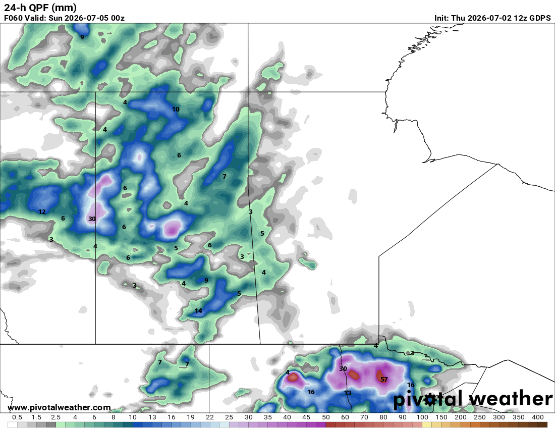
The highest tornado threat runs along and south of the Trans-Canada corridor from Swift Current east to the Manitoba border. The map below shows where thunderstorm energy will be greatest late Thursday afternoon:

If you farm in that zone, keep a close watch on the sky. Storms may initiate earlier than typical given low-level moisture already in place from overnight fog. High precipitable water values of 30 to 35mm keep flooding risk in the picture as well.
Strong thunderstorms are expected to persist overnight and track east into western Manitoba by Friday morning.
Manitoba
Scattered showers and some residual instability from the Saskatchewan system carry into southwestern Manitoba through the evening, but organized severe weather stays west of the province until Friday. Thursday is a reasonable field day across central and eastern Manitoba. Conditions are warm and partly cloudy, with highs in the low-to-mid 20s. Smoke from northern Manitoba fires remains mostly aloft. it will be a pleasantly warm afternoon, with highs in the low 20s.
Friday
Peace Region
Clouds move in overnight and Friday stays mostly cloudy, cool, and wet with highs in the teens and a good chance of chance of showers. Rainfall amounts will be minimal, but this will still be the wettest day of the period for the Peace. Field work is off the table Friday. Clearing arrives overnight into Saturday.
Alberta
Most of the province carries a thunderstorm threat through Friday, strongest across southern Alberta in the morning hours and through the eastern slopes into the afternoon. Elsewhere the day is unsettled, and showers are possible. The highest terrain west of central Alberta, and northeastern Alberta likely capture the most rainfall. Total accumulations from the multi-day event through Tuesday could reach 30mm in isolated areas, with highest amounts in the Smoky River basin. Southern Alberta sees drier afternoon weather with the best chance of any wet weather staying confined to the foothills, though any significant rainfall there is unlikely.
Air quality concerns in northern Alberta persist Friday as smoke continues to funnel into the region. The worst of Alberta’s active period should be winding down by Saturday as weak ridging builds in from the west.
Saskatchewan
Thursday’s severe storm complex tracks east overnight and reaches western Manitoba by Friday morning, but residual showers and thunderstorms remain possible across southern Saskatchewan through the day. The morning carries the strongest threat near the US border. Afternoon thunderstorm risk covers the entire province, with the environment less charged than Thursday but still capable of producing isolated strong storms. All of this makes temperature forecasting extraordinarily difficult. Areas that see more sun and stay dry will warm to the high 20s. Showers and storms, though, will keep daytime temperatures to the low 20s in areas affected by the wet weather. If your fields in central or western Saskatchewan were spared Thursday’s heavier cells, Friday morning offers a limited window to assess conditions before the next round.
Manitoba
Thursday’s organized storm complex arrives in western Manitoba by Friday morning, bringing the severe weather threat to the province. The southern border area carries the strongest morning risk. If you have a southern Manitoba operation near the US border, treat Friday morning as a high-risk period. Check Environment Canada’s severe weather watches before heading out. Across the province, temperatures in the afternoon will peak in the high teens and low 20s.
Saturday
Peace Region
A welcome turnaround. Mainly sunny with a high near 20 and a clear overnight low around 5. Saturday could be one of the best days of the period for the Peace Region. Get your spray equipment out. Fields that have had a day to dry from Friday’s showers should be workable on lighter soils by Saturday afternoon.
Alberta
Weak ridging builds in from the west and produces a noticeably better day across the province. A thunderstorm threat remains in the forecast across Alberta, but the overall intensity and coverage are lower than Thursday and Friday. Southern Alberta has the cleanest conditions of the period on Saturday. Use the morning hours before any afternoon convection fires near the foothills. The pattern continues – afternoon storms forming over the foothills and drifting east. Central and northern regions see lingering shower chances, and there is the potential for 6 to 12 mm accumulation in central Alberta, but the improving trend is clear.
Saskatchewan
Thunderstorms remain possible across the province Saturday, with activity carrying into all agricultural areas through the afternoon. The environment has moderated from Thursday’s extreme setup, but instability rebuilds quickly under the continued omega block pattern. Morning hours Saturday are your better bet for field operations across central and western Saskatchewan before afternoon heating drives convection. Southern Saskatchewan carries a continued afternoon severe threat.
The map below shows rain expected Saturday in Saskatchewan:

Highs in Saskatchewan Saturday will reach the low to mid 20s, with warmer weather in the southwest where rain is not expected. Highs there could range from 25 to 30.
Manitoba
Thunderstorms spread across all agricultural areas of Manitoba Saturday afternoon. The province warms noticeably, with temperatures climbing into the mid-to-upper 20s ahead of the building warmth. The afternoon storm threat is real but less organized than Friday. Scout emerged crops and assess any damage from Thursday and Friday’s storms during morning hours Saturday before the next round develops.
Sunday
Peace Region
Sunday will be a beautiful day in the Peace – mainly sunny and warm with highs climbing to the low 20s. A reasonable day for the Peace, though afternoon thunderstorm development can’t be ruled out. Morning conditions are your best window for any remaining spray or field work.
Alberta
The thunderstorm threat covers all of Alberta on Sunday, with rain threats in the Wood Buffalo area and across west-central Alberta through the afternoon. The foothills and northern areas see the most active conditions. Southern Alberta carries a lower threat Sunday relative to the week’s peak on Thursday, but isolated thunderstorms remain in the picture for the afternoon. The overall pattern continues to support daily convective development with the omega block still in place. Afternoon thunderstorm risk along the foothills is a persistent feature through this period. Highs in southern Alberta will reach the low 20s. With the wetter, and more unsettled weather in central and northern Alberta, highs in most areas will likely remain in the high teens.
Saskatchewan
All agricultural regions of the province carry a thunderstorm threat Sunday, with the morning rain threat concentrated across central Saskatchewan and the afternoon convection province-wide. Heat builds further along the southern border, with hot temperature warnings possible near the US boundary. Wind gusts are expected in central Saskatchewan associated with any organized convection. Sunday is not a clean field day, but the southwestern corner of the province has better odds of workable weather. In the south, temperatures are likely to reach the mid 20s, but elsewhere, they’ll remain in the high teens to low 20s in the afternoon.
Manitoba
The province warms significantly Sunday, with highs reaching the mid to high 20s. Humidex values across southern Manitoba will make conditions feel uncomfortable, and a hot temperature warning is likely for southwestern areas. All agricultural regions carry afternoon thunderstorm risk. The Interlake sees an afternoon rain threat. Storms that develop in southern Manitoba Sunday are capable of producing damaging winds and hail given the instability and moisture loading from the week’s active pattern. Watch for crop stress signals on your emerged fields going into Monday. Repeated heavy rainfall events and saturated soils through June and into early July raise root disease risk in canola and pulse crops. Scout for signs of sclerotinia stem rot initiation and blackleg on any fields that have been under persistent wet stress.
EVENT FORECAST
Calgary Stampede
Friday – Mainly sunny, slight chance of afternoon showers and storms, high 21
Saturday – Sunny, windy, high 23
Sunday – Morning cloud, afternoon clearing, high 18
The post Prairie Weather This Week – Midweek Update July 2 first appeared on Rural Roots Canada.