Prairie Weather This Week – Midweek Update Apr 30
This post was originally published on this site.


Prairie Weather (Rural Roots Canada) – Sunny, summer-like weather continues in Alberta and western Saskatchewan, while the eastern prairies stay cool
High pressure dominates the Prairies, bringing sunshine and warmer weather to the western Prairies, though cooler weather continues in eastern Saskatchewan and Manitoba. Patchy fog is expected over portions of Saskatchewan and Manitoba during the next few nights under the ridge. A low-pressure system approaching from the Northwest Territories will bring a cold front to northern Manitoba on Friday evening, delivering showers that may transition to snow overnight, and possibly freezing rain ahead of the changeover.
Looking beyond the weekend, a couple of weak disturbances are forecast to ride over the ridge as they move eastward. These systems will attempt to push cooler Arctic air back into the eastern Prairies late in the weekend and early next week. Meanwhile, stronger ridging over western regions should keep temperatures near or above seasonal levels across Alberta and the Peace Region.

In the winter, the Yellowhead Highway is often the boundary separating colder, snowier weather in the north from warmer, drier air in the south. At this time of year, the warm/cold separation continues. The map below, showing temperatures expected Sunday afternoon, shows the Yellowhead is still a boundary of sorts, separating the warmer and cooler air masses:

Thursday
Peace Region
A west coast upper ridge builds inland and is already nudging the Peace Region toward more seasonal temperatures. Double-digit high temperatures are expected on Thursday, even reaching the low teens in some areas. It’s a noticeable improvement after the prolonged cold stretch that has kept the region below average through much of April. Light southerly winds. Lows could touch zero overnight, and patchy fog is possible in low-lying areas and river valleys Thursday night under the ridge, particularly where surface moisture is available. Grande Prairie’s long-term average high for late April is around 12 degrees. Thursday, temperatures return to those long-term averages, and the trend is upward.
Alberta
High pressure dominates Alberta and delivers a welcome sunny day to most of the province. Central Alberta should reach the high teens, and highs in southern Alberta will climb into the low 20s. No significant weather is expected; just sunshine and a light northerly wind developing in the afternoon. The Arctic high that has suppressed temperatures across the prairies this week is finally sliding east. In its place, the building ridge allows daytime heating to take hold with little resistance. Cloud cover will be minimal across central and southern Alberta, maximizing sunshine hours. Thursday is an ideal day for canola and cereal seeding decisions in southern Alberta. Soil temperatures in the Lethbridge and Brooks districts have likely crossed the critical 7–8°C threshold at the 2 cm depth after several warm days. Confirm with a soil thermometer before committing. One warm afternoon does not define the trend, but it does warrant a close look.
Saskatchewan
Saskatchewan is in a transitional state. The Arctic high that has kept temperatures suppressed and made cloud forecasting due to evaporation from the surface is gradually giving way. The cooler air is slowly moving out, so temperatures will rise to the mid-teens across southern and central Saskatchewan on Thursday. Patchy fog is possible Thursday night across much of central Saskatchewan as light winds, surface moisture, and clear skies combine under ridge conditions. If you are in the Saskatoon to Prince Albert corridor, visibility could drop sharply after midnight. The cool April has set the season back somewhat in central and eastern Saskatchewan. Soil temperatures in the 0–5 cm layer are likely still running below optimal seeding thresholds for most crops in the east, though the southwest has warmed considerably. As always, there will be local exceptions, as some areas dry out and warm up faster than others.
Manitoba
An upward temperature trend has finally begun in Manitoba, though it will be slower than the trends seen in Saskatchewan and Alberta. And perhaps more temporary, as we’re watching for an arctic low to reach the province late this weekend or early next week. Temperatures should reach at least the high single digits in southern Manitoba on Thursday. That is still below average for late April. Morning wind chills could make it feel closer to -3°C early in the day, so dress accordingly if you are working outdoors. Stratus cloud and patchy fog are the main complicating factors in the forecast for Manitoba this week. With the ridge of high pressure overhead and considerable surface moisture in place, low cloud can develop and persist, creating significant temperature differences over short distances. Areas under cloud may struggle to reach 6°C on Thursday, while those with even brief breaks could even reach the low double digits. The prolonged cool period has delayed soil warming across the province. The Red River Valley and Portage la Prairie region are among the areas where conditions will need to be assessed most carefully before seeding begins — standing water or saturated soils from recent cool weather can significantly shorten the planting window.
Friday
Peace Region
Friday brings continued warming to the Peace Region as the ridge strengthens overhead. Highs should climb to 13 to 16 degrees, with Grande Prairie and Peace River both seeing a good deal of sunshine. Winds remain light and southerly. The warming trend is supporting rapid soil temperature gains, particularly on south-facing slopes and lighter-textured fields. One thing worth watching for Friday: a cold front associated with the low-pressure system approaching from the NT is forecast to reach northern Manitoba by Friday evening. The Peace Region is well removed from that system, but producers in the far northeast of the region should stay aware of the broader pattern, and prepare for possible change late in the weekend or early next week.
Alberta
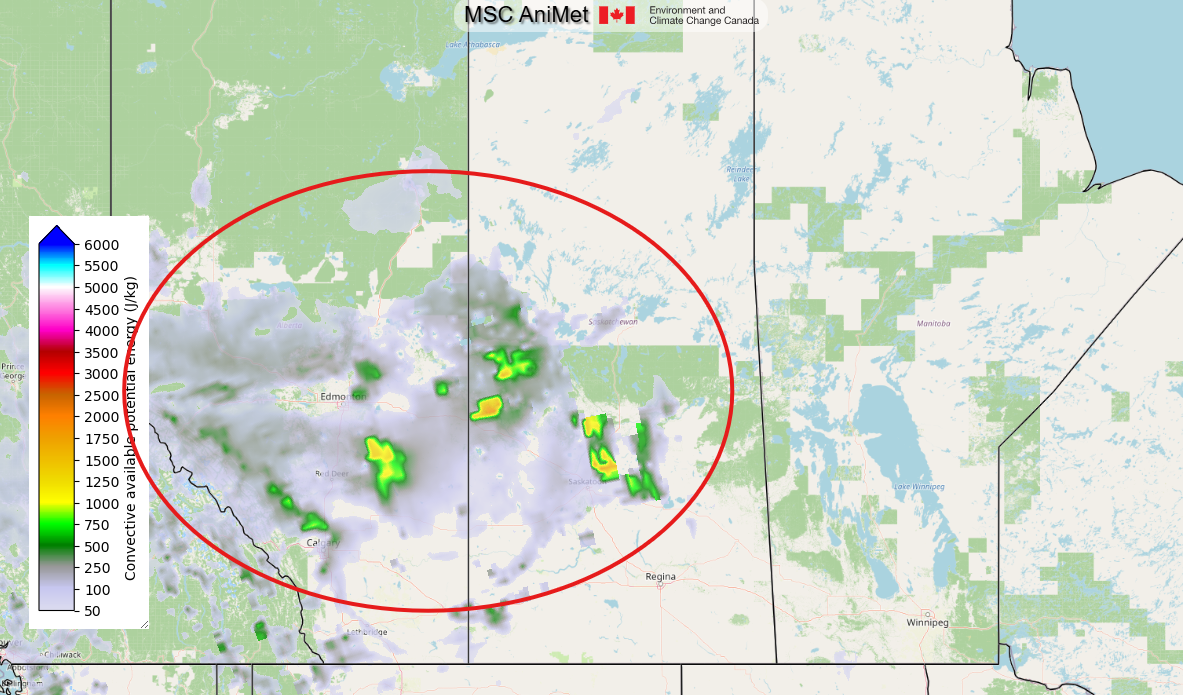
Sunny and warm across Alberta on Friday. In central and south-central Alberta, temperatures will reach the low 20s, and in southern regions, the mid 20s are possible. The ridge is at or near its peak influence over the province, delivering the kind of late-April/early-May weather that accelerates the spring season quickly. However, Alberta’s weather will change again on the weekend, with a return to slightly cooler weather. Friday is close to ideal for spring field work across Alberta. That said, the atmosphere could be a bit unstable, and the map below shows where convective showers or storms are possible. The map is valid for late afternoon Friday:

The map above is not an exact forecast of the location or timing of showers and storms, but should be used as guidance to show possibilities. If storms develop, they are expected to be weak and isolated.
Saskatchewan
Referring to the map above, convective showers and storms are possible on Friday afternoon near Saskatoon, Lloydminster, and Meadow Lake. If they do develop, any storms will be weak and isolated, staying below the severe threshold.
Otherwise, Friday is shaping up to be the warmest day of the period for Saskatchewan. Highs across central and southern Saskatchewan should reach the low 20s. These are the kinds of temperatures that dry out a field in a hurry and move the planting calendar forward fast. Enjoy it while it lasts. As you will read below, the weather changes again on the weekend, particularly for eastern Saskatchewan.
Manitoba
A significant improvement for Manitoba on Friday. Temperatures across southern Manitoba should reach the mid-teens. It’s the warmest day of the stretch and a welcome change after the prolonged below-average temperatures. The warming is driven by the upper ridge of high pressure pushing east from Alberta and Saskatchewan. The main weather event for Manitoba on Friday is a cold front approaching from the Northwest Territories, forecast to swing through northern Manitoba Friday evening. The front will bring showers to northern regions, with the potential for those showers to switch to snow overnight as temperatures drop. Freezing rain is possible in some areas before the changeover. But for southern Manitoba, Friday itself remains dry and mild.
Saturday
Peace Region
The Peace Region sees a mainly sunny day Saturday, with the high-pressure ridge deflecting incoming storms to the north. Highs remain seasonable at 11 to 14 degrees, and conditions stay dry for most of the region. There is a slight chance of a shower or brief flurry in the far northwest near the BC border, where the first disturbance tracks through. Overnight lows Saturday night drop to near freezing. If you have any tender crops already in the ground, keep an eye on overnight readings through the weekend.
Alberta
South central Alberta holds onto a decent day Saturday with sun and cloud and a high near 14°C. There is a possibility of afternoon showers in a line from Calgary northwest to Edson and Jasper. Under most scenarios, these showers would be isolated and brief. However, an upslope circulation around a weak low west of Saskatoon may produce some steadier precipitation. It all depends on the strength and exact position of the low. This heads-up is mainly for producers in the vicinity of Calgary. Edmonton and central Alberta will be a bit cooler, with highs from 11 to 13. The pattern is transitioning. After the exceptional warmth of Thursday and Friday, Saturday marks the beginning of a more variable stretch. Temperatures will be cooler, cloud cover will increase, and the chance of precipitation rises, particularly across northern and central regions.
Saskatchewan
Saturday brings a notable cooldown to Saskatchewan after Friday’s exceptional warmth. Saskatoon drops to around 14 degrees with sunshine and late afternoon cloud, which sounds good but is a 9-degree retreat from Friday’s high. Regina comes in at about 14 as well. The cool comes partly from overnight lows dropping sharply: Saskatoon sees a low near 0 Saturday night, and temperatures could dip below zero in some rural areas. The pattern is holding drier across most of the south on Saturday, but cloud increases are expected by afternoon across central Saskatchewan. The disturbance tracking across northern regions could bring some light precipitation to the Prince Albert and Nipawin areas. The temperature drop from Friday to Saturday is not unusual for early May on the prairies; it shouldn’t derail a seeding program that’s already underway, but frost protection for any emerged seedlings should be considered.
Manitoba
A passing cold front from a Low in Nunavut will affect the province on Saturday. Northern Manitoba will see cooler temperatures and cloud, with flurries possible in some areas north of Thompson as the air mass behind the front settles in. Winnipeg and southern Manitoba will be mostly cloudy with highs in the mid-teens, cooler than Friday but still reasonable. The front could produce some late afternoon showers in southwestern Manitoba, south of Riding Mountain National Park. The front will gradually push through the eastern Interlake and areas near the Ontario border Saturday, with showers possible in those areas during the evening. Behind the front, conditions stabilize.
Sunday
Peace Region
Partly to mostly sunny skies across the Peace Region on Sunday. Temperatures settle in the high teens with another dry day across the area. No significant weather is expected, and with a light wind, conditions will be nearly ideal for field work.
Alberta
As seen on the map at the top of this post, southern and south-central Alberta will be warm and sunny on Sunday with highs near 20. The ridge reasserts itself temporarily over the south. Edmonton and central Alberta remain perhaps slightly cloudier, with highs near 17 or 18. Southern Alberta producers get another excellent day. With no significant weather expected, Sunday gives producers across Alberta a second solid field day of the weekend.
Saskatchewan
As mentioned earlier in this post, and as seen on the map at the top of this post, the Yellowhead highway will be the dividing line between cooler single-digit highs to the north and temperatures approaching 20 degrees in the south. No significant weather is expected. Sunday is another strong field day for southern and central Saskatchewan. Producers who have been seeding since Friday should be in a solid position. Those who are still assessing soil conditions should note that the warm week has almost certainly advanced soil temperatures across the south. There is less reason to wait in areas that were borderline as recently as Thursday.
Manitoba
A mix of sun and cloud on Sunday with double-digit highs south of the Trans Canada Highway. The temperature pattern this weekend is typical for early May in Manitoba: warm one day, cooler the next, with the general trend still upward. Overnight lows Sunday night drop to near freezing, which is worth watching for any emerged field crops. The cold front and precipitation that affected northern Manitoba Friday night and Saturday have cleared the south. Sunday is still a reasonable day for fieldwork in the south, but the warming trend is less sustained here than farther west.
LISTEN: RRC Meteorologist David Spence appears on Nutrien’s eKonomics Podcast
The post Prairie Weather This Week – Midweek Update Apr 30 first appeared on Rural Roots Canada.