Prairie Weather This Week – June 22
This post was originally published on this site.


Prairie Weather (Rural Roots Canada) – Wet weather continues for another week across the prairies. Thunderstorms, too!

The upper low that brought heavy rain to central Alberta over the weekend moves out. A ridge builds in Monday evening and skies clear across much of the prairies, setting up what looks like the best two-day stretch of June so far on Tuesday and Wednesday. Don’t get too comfortable. Another series of disturbances begins arriving Thursday, and by the weekend, a new low-pressure system develops over southern Saskatchewan, bringing widespread rain and thunderstorm risk back to all agricultural regions Sunday. The week follows a now-familiar pattern: active bookends with a workable window in the middle. Capture every hour of Tuesday and Wednesday. The map below shows rain accumulation up to the evening of Sunday, June 30. Rain will be plentiful over agricultural regions of the prairies this week:

The broader agricultural concern this week goes beyond just the weather events themselves. Heat unit accumulation is running behind in many areas, and canola and spring wheat that went in late need warm days to close that gap. The mid-week window delivers some of that warmth, but one or two good days don’t erase weeks of cool, wet conditions.
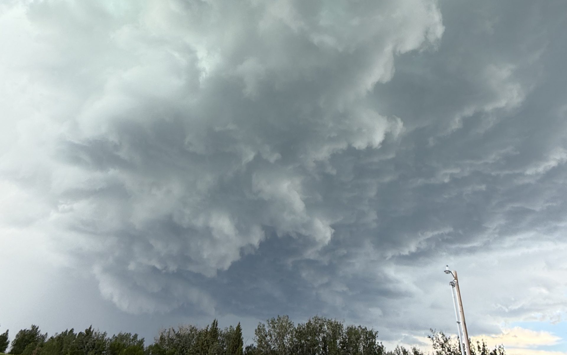
This past weekend brought heavy rain to central Alberta, with accumulations of 100 mm or greater in and near Edmonton. The south was much drier, but the sky was just as ominous. The photo below was captured near Vulcan AB on June 20 by our digital content specialist Kristen Lepp:

On the same day, near Rolling Hills, AB, our esteemed editor, Craig Lester, took this photo from the family farm:

Monday
Peace Region
A lingering chance of showers through the morning clears to a mix of sun and cloud by afternoon as the departing upper low finally pulls away. Gusty northwesterly winds continue into the early evening before easing as the ridge builds in. Highs should reach the low 20s. Monday is a transition day for the Peace. By evening, conditions improve considerably, setting up a much better Tuesday. Assess fields on Monday afternoon before committing equipment.
Alberta
The rain in central Alberta tapers off and moves southeast. Central regions will clear to cloudy periods overnight. Afternoon highs across the province will vary. In the north, where the weather has been dry, temperatures Monday should reach the low 20s. In the south, which will become wetter as the day goes on, afternoon temperatures will land in the 12 to 16 degree range. The area near Pincher Creek carries a morning severe thunderstorm threat on Monday as residual instability interacts with the departing system. Wind gusts are a concern for southern and central Alberta through the afternoon as northwest flow accelerates behind the departing low. This is not a field day for central or southern Alberta. Alberta River Forecast Centre advisories for the Smoky, McLeod, Pembina, North Saskatchewan, Battle, and Red Deer river basins should continue to be monitored through Monday for flooding risk.
Saskatchewan
Rain is likely in Saskatchewan throughout Monday, and thunderstorms can’t be ruled out, especially near Estevan and the US border. The same residual instability that is driving the Alberta activity reaches into southeastern Saskatchewan Monday morning. This is worth taking seriously. The environment near Estevan in the morning hours has the ingredients for hail and damaging wind. By afternoon, a rain threat and thunderstorm threat persist across central Saskatchewan. The afternoon is generally unsettled across the province. The wet weather will limit afternoon high temperatures to the mid-teens.
Manitoba
Temperatures will climb to the high teens or low 20s across Manitoba on Monday. For most of the province, it will be a dry day. However, some showers associated with the storm in Saskatchewan may creep toward southwestern Manitoba, close to the US border. For most of Manitoba, though, it will be a genuinely usable day relative to what is happening to the west. Central and eastern Manitoba should have a reasonable afternoon window for field work. Take advantage of it. Rain returns Tuesday.
Tuesday
Peace Region
A mix of sun and cloud with a chance of light showers developing in the afternoon. Highs will climb to the mid-20s. The Peace has a workable morning Tuesday with the best conditions of the week, but some slight instability could generate showers in the afternoon, particularly over foothills terrain. Morning hours are your priority for any spray or field work. The afternoon becomes a bit less reliable.
Alberta
Tuesday is the best day of the week for most of Alberta. The ridge has built in, the skies are clear, and temperatures return to near-seasonal levels for the first time in weeks. Afternoon highs will be near 20. Spray windows are excellent. Move herbicide equipment Tuesday. Soil conditions across much of central and southern Alberta will still be wet from the weekend rain, particularly in the river basin areas that took the most rainfall, so assess before sending heavy seeding equipment onto heavier soils. However, for lighter land that drains quickly, Tuesday could also be the best chance of the week to work the fields. Do not miss this window.
Saskatchewan
A morning rain threat across central and southeastern Saskatchewan, with a thunderstorm threat covering most of the province through the day. The highest threat in the afternoon sits near Estevan, where proximity to moisture-laden air from the US makes organized convection more likely. Temperatures return to the low-to-mid 20s across the province, which is welcome after weeks below seasonal. Central and western Saskatchewan get the better of Tuesday compared to the southeast. If you are in the Estevan area, treat Tuesday as a limited field day. Further west and north, Tuesday is a reasonable day between morning and afternoon storm windows.
Manitoba
Rain arrives in southern Manitoba Tuesday, and it will be cool, with highs in the mid to high teens at best. Rain continues into Tuesday night. The disturbance moving southeast out of Alberta reaches Manitoba Tuesday, bringing widespread rain and thunderstorms through the day and overnight. Tuesday is a down day for Manitoba. Thunderstorm risk is highest in southeastern Saskatchewan and extending into southwestern Manitoba through the afternoon. The Red River Valley carries a notable afternoon storm threat. Do not plan field work in southern Manitoba on Tuesday.
Wednesday
Peace Region
A thunderstorm threat is in place for the Peace Region Wednesday afternoon, associated with a developing disturbance to the west. Highs will reach 25 to 27 degrees. The morning hours are your window for fieldwork Wednesday in the Peace before afternoon convection develops. There is a hot temperature risk for far northern Alberta Wednesday and Thursday, though these affect areas well north of the main agricultural zones.
Alberta
Wednesday is the warmest day of the week for Alberta and the second consecutive clean day for most of the province, thanks to surface high pressure. Temperatures will climb to the low to mid-20s. Central and southern Alberta will get their best back-to-back field days since early June. The afternoon carries a thunderstorm threat across the province, with heavier potential along the US border and along the foothills. Morning hours on Wednesday are the premium spray and field operations window before afternoon heating drives convection. Far northern Alberta sees a hot temperature threat on Wednesday.
Saskatchewan
Rain along the southern half of the province before sunrise, with thunderstorms late in the afternoon following a few hours of sunshine. Wednesday’s storm threat is heaviest in the south, but scattered thunderstorms will be possible anywhere in the province. Highs across the province will reach the low 20s….though it will be a bit cooler during rainy periods. There will be opportunities in the midday to get work done, but watch the afternoon sky for rapidly developing thunderstorms. The storms may be small and isolated, but their lightning is no less deadly.
Manitoba
After Tuesday’s rain, Wednesday brings some improvement to Manitoba, though the threat of showers will carry on across southern Manitoba through the day. The morning rain threat is concentrated near Dauphin and the western portions of the province. Central and eastern Manitoba should see a decent afternoon. The Red River Valley carries the afternoon thunderstorm threat, which is the most specifically highlighted area in the whole province on Wednesday. South of the lakes, temperatures will reach the high teens. It will be much warmer in the north, with highs climbing to the low 20s. If you farm near Winnipeg or south toward the US border, be weather-aware Wednesday afternoon. Elsewhere in Manitoba, Wednesday is a usable day.
Thursday
Peace Region
A morning thunderstorm threat for the Peace Region Thursday, with the activity pushing in from the northwest. The morning threat limits early field operations. However, the rain should end before sunrise. Midday sun could help out with drying any soggy fields, but that will only end with more rain in the afternoon. A low-pressure system will develop near Grande Prairie in the late afternoon, and rain returns to the entire Peace region on both sides of the boundary. Before the late afternoon rain, highs will bounce into the low 20s.
Alberta
A morning thunderstorm threat covers all of Alberta Thursday, followed by an afternoon threat with stronger storms possible along the foothills. This is the resumption of the active pattern after the mid-week break. Thursday is still workable for most of the day across central and southern Alberta, with the foothills being the highest-risk area for afternoon storm development. Far northern Alberta continues under a hot temperature threat Thursday, where 30-degree highs are possible. Elsewhere in Alberta, it will be warm as temperatures climb to the mid 20s. Monitor Environment Canada watches through the afternoon to track developing thunderstorms.
Saskatchewan
Morning thunderstorms threaten all of the province Thursday except the southwest corner. The afternoon threat covers Saskatchewan except for the southwest. Central and eastern Saskatchewan will have dry weather in the early part of the day, but instability will lead to a real threat of storms, particularly on the eastern side of the province. Temperatures in the low-to-mid 20s continue.
Manitoba
A morning thunderstorm threat across Manitoba Thursday clears to a mix of sun and cloud through the afternoon as the system works east. However, that’s not the end of rain for everyone. Afternoon instability will create some pop-up showers and storms in the afternoon across all regions of the province. Temperatures climb to the high teens and low 20s, with partial clearing overnight. Thursday may have some usable hours, but don’t count on it. We will post our usual update here on Thursday, with greater detail on what to expect.
Friday
Peace Region
An afternoon rain threat arrives in the Peace Region on Friday as a new disturbance approaches from the west. The afternoon also carries a severe thunderstorm threat for the Peace and south along the foothills to Highway 11. Morning conditions are better. Use the morning for any remaining field work. Temperatures will climb toward the low 20s in the afternoon, then drop when the showers and storms arrive.
Alberta
The next disturbance arrives, with a morning thunderstorm threat covering most of Alberta except the Peace, followed by an afternoon rain threat along the Alberta foothills north of the Trans-Canada and an afternoon severe thunderstorm threat for the Peace and south along the foothills. The foothills corridor from Grande Prairie south to Highway 11 is the highest-risk area Friday afternoon. Stronger cells are possible there. Southern Alberta, near the foothills, should be watching the sky Friday afternoon carefully. A hot temperature threat for far northern Alberta continues Friday. East of the foothills, it will be a dry day, though some afternoon showers and storms could creep as far east as Barons, Nobleford, and Lethbridge in the afternoon. In the areas affected by showers and storms, temperatures will reach the high teens or low twenties. In the dry regions, look for highs between 24 and 27 degrees.
Saskatchewan
A thunderstorm threat covers all of Saskatchewan except the southwest Friday. Keep in mind…just because there is a threat does not necessarily mean there will be storms. Chances are greater, though, on the eastern side of the province. The southwest corner, which has consistently been in a relative precipitation shadow through this active pattern, largely escapes again Friday. Central and eastern Saskatchewan see a more active day. The southwest corner has usable conditions Friday. Highs across the province should reach the mid-20s.
Manitoba
A morning thunderstorm threat across Manitoba Friday. Afternoon conditions improve across most of the province until daytime heating produces scattered convective showers and storms across the province from south to north. Temperatures are climbing toward the low to mid 20s. Friday could be the warmest day of the week for the province and one of the best fieldwork days of the period, but again, the sky should be watched closely in the afternoon for pop-up showers and storms. Push hard on any outstanding work Friday in Manitoba.
Rainy Weekend
Most of the rain you saw on the map at the top of this post will fall on the weekend. The map below shows how much rain is expected to fall across the prairies, specifically on Saturday and Sunday alone:

Do not refer to the map above as an exact forecast. The weekend is several days away, and it’s far to early to be able to predict rainfall amounts with any hope of accuracy. However, the map does give a good indication of where rain will fall, and suggests heavily that field work will be impractical on Saturday and Sunday across most agricultural regions.
In situations like this, it is almost pointless to try to produce a day-and-region-specific forecast this far ahead in time. There is too much uncertainty beyond the fact that it will be a wet weekend, and temperatures across the prairies over the weekend will be affected by the rain. In the southern half of the prairies, temperatures will reach the mid-teens Saturday and Sunday, and in the north, it remains very warm, with temperatures climbing to the high 20s. This continues the pattern of hot, dry weather for the northern prairies all week, and the fire threat there has to be taken seriously.
The broader agricultural picture remains concerning. Cool temperatures through the extended active pattern have slowed crop growth and heat unit accumulation. Canola and spring wheat that went in late need warmth, and while mid-week delivers some of that, the overall trend for late June is still running below seasonal norms. Producers with late-seeded fields should be tracking heat units closely and factoring that into their fall management plans. The window for adequate growing degree day accumulation before the first fall frost is tightening. This is not yet a crisis, but it is a trend worth watching.
The post Prairie Weather This Week – June 22 first appeared on Rural Roots Canada.