Prairie Weather This Week – April 13
This post was originally published on this site.


Prairie Weather (Rural Roots Canada) – April showers in the southern prairies … and mid-April snow.

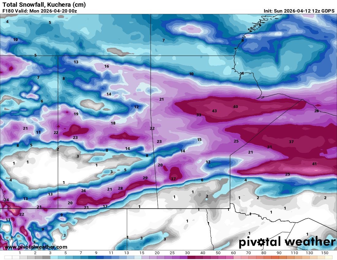
Another week of significant snowfall is expected across the southern and northern portions of the prairies, providing moisture for much of the agricultural territory. The map below shows total snow amounts expected by Sunday evening. Most of the southern prairie snow will fall when a storm crosses the northern US on Thursday.

As the map shows, parts of southern Alberta and southern Saskatchewan can expect around 20 cm of snow. Separate systems will provide about the same amount of snow to northern Alberta and northern Saskatchewan. And while agricultural properties in western Manitoba may share in the bounty, the rest of southern Manitoba remains dry.
Monday
Peace Region
The Peace Country is sitting on the quiet side of the weekend’s activity, with high pressure consolidating over northern Alberta. Partly cloudy to mostly sunny skies are expected, and temperatures will be noticeably moderate, with daytime highs climbing to near 8 degrees. It’s a short break. A low-pressure system passing to the north will create some unsettled conditions going into the evening, and with lows dropping to near -5, some light, scattered snow cannot be ruled out overnight, especially over higher terrain.
Area fields still have some snow cover, as seen in this image from Demmit:

Expected Monday sunshine will get rid of much of this snow, only to have it replaced as the next system rolls through.
Alberta
Monday is the warmest day of the week across much of Alberta. Daytime highs will be the warmest of the period, reaching 13 to 14 in Calgary and 17 to 18 in the south, and 8 to 10 across central regions. The warmth will be welcome but brief, as a system is already beginning to move in from BC and will make its presence known overnight, with rain and snow developing in northwestern Alberta. Producers looking for a window for spring fieldwork or calving operations should plan around Monday. Overnight lows will be near or just above freezing in the south.
Saskatchewan
Monday continues a warming trend across the province. High pressure to the northwest keeps the day mostly sunny to partly cloudy, and temperatures are seasonable. Southern regions can expect highs of 11 to 13 degrees, with central Saskatchewan in the 6 to 8 degree range. A chance of showers arrives by late in the day across the south near the US border, as the first of this week’s disturbances moves north out of the U.S. Plains, but most of the province will stay dry through Monday. Producers in southern and east-central Saskatchewan should be watching soil conditions closely as snowmelt accelerates under these warm, dry conditions.
Manitoba
Cooler air builds southward into Manitoba on Monday. Daytime highs will be near 5 degrees across southern agricultural regions, which is a bit of a setback from the weekend warmth. Partly cloudy skies and a northwest wind will make for a raw feel despite temperatures above freezing. The cooler air will temporarily slow the snowmelt underway in the Dauphin and Interlake regions. A chance of flurries in the afternoon across northern and central areas, and there may be some evening rain showers along the US border, likely south of Morris. Conditions should be otherwise quiet as the province breathes between systems.
Tuesday
Peace Region
Cloud cover increases across the Peace Region through Tuesday as the next system approaches from BC. The upper low sitting over northern California and the broad long-wave trough over the western United States are directing a new wave of energy into the Rockies. Expect partly to mostly cloudy skies with a chance of rain or wet snow by afternoon, particularly in the south Peace and at higher elevations. Daytime highs will be near 4 degrees, a bit cooler than Monday.
Alberta
The new system moving in from BC begins to make its presence felt across Alberta on Tuesday. Central and northern regions will see increasing cloud cover and a chance of flurries or light snow by afternoon, with heavier accumulations possible in the foothills and along the eastern slopes. Southern Alberta will be milder, drier, and sunnier. However, a rain or a rain-snow mix will develop as a Low moves into southern Alberta from the northwest during the evening. Expect daytime highs around 11 to 15 in southern and south central Alberta, cooler to the north. A separate disturbance crossing the northern U.S. Plains will also bring a chance of rain showers to southwestern Saskatchewan and southern Alberta, so the south can expect active weather overnight.
Saskatchewan
Tuesday is the most active weather day of the week for Saskatchewan. A disturbance crossing the northern U.S. Plains pushes rain showers northward across the southern Prairies through the day. Rain is the dominant precipitation type across southern agricultural regions, with highs reaching 15 to 18 degrees in the south. Localized accumulations of 5 to 15 mm are possible in the heavier shower bands. The activity should taper from west to east through the afternoon and evening. Showers will redevelop in central and southern regions overnight. Northern Saskatchewan will see mainly cloudy conditions with light snow or flurries. Expect rapidly softening field and road conditions with the rain and well-above-zero temperatures.
Manitoba
Tuesday brings a significant warmup to Manitoba, particularly the south. The warm sector ahead of the approaching system lifts daytime highs to near 10°C in Winnipeg and the Red River Valley, with highs in the low teens possible in Westman. A chance of showers develops near the US border as the second disturbance in as many days crosses the Northern Plains. There is some potential for elevated convection, with localized rainfall of a few millimetres possible in the stronger cells. Cloud cover will be extensive through the day. Snowmelt will accelerate rapidly across regions still carrying cover. Indeed, most of southern Manitoba is now snow-free, but some areas of western Manitoba still have snow. The image below is from Bowsman:

Wednesday
Peace Region
Conditions across the Peace Country turn unsettled again on Wednesday as the low reforming in the lee of the Alberta Rockies deepens and begins tracking northeast. Periods of snow are likely, with accumulations of 10 cm possible. Daytime highs will be near -2, back below the freezing mark. Wind will increase from the northwest as the system organizes. This is the first of what could be a more active mid-to-late week pattern, and producers should monitor the forecast closely.
Alberta
Wednesday is a day to watch closely across Alberta. A broad upper trough extending into the northwestern Prairies, combined with an upper low over northern California, is expected to support the development of a new surface low in the lee of the Rockies. This system will bring a band of accumulating snow to central Alberta through the day and into the evening, with the heaviest snow possible along the Yellowhead corridor and in the foothills. Southern Alberta will be on the rain-snow line, with precipitation type dependent on how quickly cold air filters southward behind the system. Daytime highs will drop noticeably, except south of the Trans-Canada highway, where temperatures could reach 10 to 14 degrees. It will be colder along the foothills and in central and northern Alberta, where temperatures may remain below the freezing mark. North of the Yellowhead highway, there is the potential for 12 to 20 cm of snow, though there remains some uncertainty.
Saskatchewan
The mid-week disturbance brings a broader chance of rain changing to snow across Saskatchewan on Wednesday. The rain-to-snow transition is the key forecast challenge. It will hinge on how quickly cold air wraps around the back of the system. Southern regions south of the Yellowhead may initially see rain, then a changeover to snow as temperatures fall through the afternoon. Central and northern Saskatchewan will see snow throughout. Daytime highs in the mid-teens in the south will fall rapidly as cold air advances toward evening. Travel could be impacted across the Yellowhead and Trans-Canada corridors by evening, and producers should be aware of the potential for quick and significant accumulations.
Manitoba
Wednesday brings a significant precipitation event to Manitoba. The Interlake and southern Manitoba can expect showers, with steady snow falling north of the Lakes. Temperatures will reach double digits in the south and in the Interlake. The exact track and speed of the low will determine where the heaviest snow falls. This system needs to be watched closely.
Thursday
Peace Region
Cold air consolidates across the Peace Country on Thursday in the wake of Wednesday’s system. Daytime highs will be near or just below freezing, with a northwest wind adding a raw bite to the air. The sky will be mainly sunny to partly cloudy, with a chance of showers or flurries developing late in the day as yet another low moves in from northern BC. Accumulations will be minimal. The freeze-thaw cycle will reassert itself, which is not unwelcome for soil moisture infiltration, but the cold snap will be a reminder that winter has not fully relinquished its grip on the region.
Alberta
The cold airmass drops southward across Alberta behind Wednesday’s low, bringing temperatures back well below seasonal. Daytime highs across most of central Alberta will be in the low single digits, with southern areas near 1 to 3 degrees. Blowing snow is possible in open areas of central and southern Alberta, where Wednesday’s accumulations were significant, and northwest winds remain brisk. After morning snow south of the Trans-Canada highway, the sky will gradually clear throughout the day as the Arctic high builds from the northwest. Overnight lows will fall to -8 to -10. There are hints at the potential for another round of development in the lee of the Rockies by late Thursday into Friday, which is a pattern very consistent with Alberta clipper activity. This will require close monitoring.
Saskatchewan
Thursday is cold and blustery across Saskatchewan following Wednesday’s system. Blowing snow in open agricultural areas is a significant concern, particularly across the southern Prairies where northwest winds remain gusty. Daytime highs will be near -5 all across the province, including southern agricultural regions. Visibility reductions are possible along the Trans-Canada and Yellowhead corridors through the morning before winds ease through the afternoon. The cold reinforces the below-normal temperature anomaly that has been persistent across the northern Prairies since early April.
Manitoba
Thursday remains cold and unsettled across much of Manitoba. The departing low will leave a swath of snow across the province, and northwest winds will cause blowing and drifting snow through much of the day, particularly across the open agricultural regions south and west of Winnipeg. Travel disruptions are possible with rain, freezing rain, and snow, all possible during the day in the Interlake and southern Manitoba. Daytime highs will be near -4 to -2 across southern Manitoba. Depending on the position of the surface low late in the day, there is the possibility of an influx of warm air into southeastern Manitoba, mainly in the forest east of Highway 12. Temperatures there could get into the 5 to 7 degree range, but this is by no means a certainty.
Friday
Peace Region
After a few morning showers or flurries, conditions dry out across the Peace Country on Friday as an Arctic high builds firmly over the region. Mostly sunny to partly cloudy skies are expected, with daytime highs climbing back to near 3 to 8 degrees, still below seasonal, but a bit warmer than Thursday. The freeze overnight will be sharp, with lows falling to near -10°C. River break-up conditions will continue to be monitored across the Peace River drainage, given the above-normal snowpack that has accumulated through the winter.
Alberta
Friday brings a return to quieter weather across much of Alberta under the influence of building high pressure. Mostly sunny skies and light winds will allow temperatures to recover modestly, with daytime highs of 5 to 8 degrees in the south and 3 to 5 degrees in central areas. The foothills and eastern slopes will still see some cloud and the chance of flurries, as the tail end of the departing disturbance clears. Southern Alberta producers will be watching soil conditions carefully after the mid-week precipitation, and the drier and warmer end-of-week conditions will be welcome for anyone planning spring fieldwork.
Saskatchewan
Friday continues the recovery across Saskatchewan as high pressure holds firm. After morning rain and snow in southeastern Saskatchewan, partly cloudy skies and light winds support a good drying period in the afternoon, with highs of 5 to 8°C across southwestern agricultural regions and -2 to -4 elsewhere. The province will need a few consecutive days of this type of weather to begin making up the soil moisture deficit in some areas, though the mid-week rain and snow will have provided meaningful recharge where it fell. Northern forests will see more clouds and the chance of isolated flurries through the day. The overall pattern remains cooler than average, and the next system will need to be watched as it comes off the Rockies by the weekend.
Manitoba
Wet weather is in store for Manitoba as a low that crossed northern North Dakota moves into northwestern Ontario, feeding moisture back into southern Manitoba. It’s expected that the moisture could start as rain, as daytime highs will be near 3 to 5 degrees, but will turn to snow toward evening as it cools down. Overnight lows will range from -8 to -10, reinforcing the freeze that will help control the pace of snowmelt heading into the weekend. Producers across the Interlake and western Manitoba will be assessing field conditions after what could be a significant mid-week accumulation.
Saturday and Sunday
The broader pattern signal for the second half of the week and into the weekend points toward continued below-normal temperatures across the northern Prairies.
The Alberta Clipper risk is the key storyline heading into the weekend. There are consistent hints suggesting another round of lee-of-the-Rockies development is possible late in the week, with a system potentially pushing eastward across the Prairies Saturday into Sunday. Details at this range are highly uncertain. Track, intensity, and precipitation type all remain open questions. What can be said is that temperatures will remain near or below average across all three provinces through the weekend, with overnight lows likely in the -5 to -10 range, and that any clipper tracking the usual central Alberta to southern Manitoba path would bring accumulating snow to areas that have already seen a very active stretch this spring.
COMPARE: Prairie Weather This Week – April 6
The post Prairie Weather This Week – April 13 first appeared on Rural Roots Canada.