
Prairie Weather This Week – August 2
This post was originally published on this site.


Prairie Weather (Rural Roots Canada) – Similar weather pattern – wet in the north, dry in the south. A bit cooler.
The weather pattern that brought this weekend’s severe storms and Saturday’s record heat is finally moving out. In its wake comes a much cooler stretch of weather to start the week.
Monday will still be unsettled, with lingering heavy rain in the northeastern prairies and gusty winds easing through the morning. Afternoon highs will only reach the upper teens to low 20s. That’s a dramatic change from the mid-30s many communities experienced just a few days ago. By midweek, overnight temperatures in parts of western Alberta could dip into the single digits.
Despite the cooler air, this system won’t deliver much meaningful rainfall for most of the Prairies. After two weeks of hot, dry weather, soil moisture has been declining. Crops are beginning to show signs of stress. The lower temperatures will slow moisture loss, but they won’t reverse the drying trend.
Temperatures rebound to near seasonal levels by midweek and should remain there into next weekend. There is no sign of a return to the intense heat we’ve seen through much of the summer.

IT WAS HOT!
15 Alberta locations set high temperature records on August 1. In Calgary, the previous record was set back in 1893:

And, there were 5 record highs set in Saskatchewan on the same day:

Monday
Peace Region
The low responsible for the weekend’s heavy rain is all the way into Saskatchewan by morning. On its way out, it gave impressive overnight rainfall totals to parts of northern Alberta, with some communities approaching 100 mm. In the Peace Region, the event is over, and the sky will be sunny today as cooler, drier air moves in. If you were under the heavier rain bands, check fields for standing water and give saturated areas time to drain before taking equipment back in. Across the Peace, expect highs in the low 20s.
Alberta
The last of the heavy rain over northeastern Alberta tapers off very early this morning as the system exits into Saskatchewan. Strong northwest winds that gusted up to 90 km/h over the weekend will gradually ease. With wet ground, it’s a good idea to check trees, shelterbelts and farmyards for any wind damage. Cooler, cleaner air follows as the cold front pushes wildfire smoke out of the province. Highs that were in the mid-30s this weekend will only reach the low 20s today across much of central and southern Alberta.
Those in southern and south-central Alberta may wake up to rain Monday morning, but it will quickly move out. It’s a welcome break from the heat. Temperatures only reach the teens in central Alberta, and the low 20s in the south.
Saskatchewan
The severe weather that swept across parts of the province over the weekend is now moving away. As the Low moves into northern Manitoba, it will still drag some rain across the province during the day. Much cooler air settles in, bringing temperatures back to near-seasonal levels, though south of the Trans Canada Highway there is still the potential for temperatures to climb into the high 20s. A little wildfire smoke may still drift across southern Saskatchewan from the Pacific Northwest and southern B.C., creating haze, but overall conditions slowly improve through the day.
Manitoba
Southern Manitoba is the last part of the Prairies to cool down after Sunday’s heat, with temperatures reaching the low 30s in some areas of the Red River Valley south of Winnipeg. A few overnight thunderstorms lingered across northern and southeastern Manitoba, but those will move out by afternoon. However, rain will continue to fall through the day in the Interlake and northern Manitoba. With a westerly wind, most of the agricultural south will remain dry. Monday will still feel warm, but noticeably cooler air arrives Tuesday, bringing temperatures back to more typical early-August levels.
Tuesday
Peace Region
Tuesday will be a quiet weather day in the Peace, with plenty of sunshine and pleasantly warm weather, as highs reach the low 20s. A few clouds may form over higher terrain, but otherwise it will be an uneventful day. This would be a good opportunity to assess the results of recent rainfall. Totals varied considerably across the region, with some fields receiving much more moisture than others.
Alberta
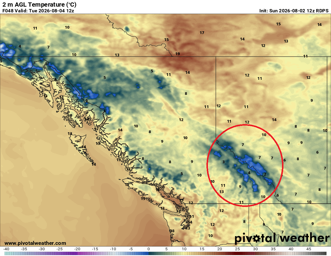
Today will be the coolest day of the week. Overnight lows dip into the single digits in parts of central and western Alberta, while afternoon highs struggle to reach the low 20s. Early morning temperatures could drop below freezing in the higher terrain of the Rockies, including the Icefields Parkway (dark blue on the map below):

Obviously, the area of the freezing weather does not include agricultural regions, and the map above shows those areas remaining well above zero overnight.
Nonetheless, it’s a dramatic change from the mid-30s many areas experienced just a few days ago. The cooler temperatures will reduce crop stress and slow evaporation, but they won’t make up for the lack of widespread rainfall across much of southern Alberta.
Saskatchewan
Temperatures settle back to near seasonal levels Tuesday, with highs generally in the low 20s. Dry weather and light winds provide favourable conditions for field work, including spraying and swathing, although producers will continue watching soil moisture closely after the recent stretch of hot, dry weather in the southern part of the province.
Manitoba
The cooldown finally reaches Manitoba Tuesday. After temperatures climbed into the low 30s over the weekend, highs will be back in the low 20s with noticeably lower humidity. Dry conditions return to agricultural regions behind the departing system, allowing fields to begin drying where heavier weekend showers occurred. There is potential for some rain in the Canadian Shield east of Lake Winnipeg, and into northwestern Ontario. Northern Manitoba will see some light rain, as well, with accumulations less than 5 mm.
Wednesday
Peace Region
The cool, unsettled stretch is now behind us, with conditions settling down across the Peace Region. Temperatures begin a slow recovery today after the early-week cooldown, with mainly dry weather and light winds creating a good opportunity for field work. Expect highs near 25 or 26 degrees. After the recent rain, producers will get a better sense of how much moisture soaked into the soil and where additional drying time is needed.
Alberta
The upper-level system responsible for the cooler weather begins moving away today, allowing temperatures to climb gradually. The warm-up will be slow and steady rather than a sudden return to the heat, with Edmonton, Calgary and much of central and southern Alberta trending a few degrees warmer than earlier this week. Highs in central and northern Alberta will reach the low to mid-20s, and in the south, expect afternoon temperatures in the mid-to-high-20s. The combination of sunshine, lighter winds and dry conditions should provide a favourable window for field operations, although moisture deficits remain a concern in areas that missed the weekend rain.
Saskatchewan
A quiet weather pattern settles in across Saskatchewan, with temperatures slowly returning toward seasonal values. An area of low pressure will develop northeast of Saskatoon, and rain returns to central and northwestern Saskatchewan, north of the Yellowhead Highway. Most regions will get 5-10 mm during the day. Dry weather remains south of the Trans Canada Highway, with highs in the 21 to 25 degree range. In central and northern regions, where the rain happens, highs will only reach the high teens or low 20s at best. Producers will be watching fields closely as crops continue to develop under increasingly variable moisture conditions across the province.
Manitoba
Manitoba settles into a more typical early August pattern today, with temperatures holding near seasonal levels and mostly dry conditions continuing. The humidity is lower following Tuesday’s cooldown, making it a comfortable day for field work. By late afternoon, some light rain will develop in the Interlake and in areas north of Dauphin and west of Lake Winnipegosis. With no major weather systems expected over most agricultural regions, producers should see a useful window to get caught up after the unsettled weather of the past few days.
Thursday
Peace Region
The gradual warm-up continues across the Peace Region as temperatures recover from the sharp cooldown earlier this week. Highs Thursday should again climb to the high 20s. Expect bright sunshine as conditions remain mostly dry and settled. After the recent swings from heat to heavy rain and cooler weather, this stretch should provide a more stable window for field operations. Producers will be assessing where the recent rainfall provided a meaningful moisture boost and where soils remain dry.
Alberta
The warming trend that started Wednesday continues today, with temperatures climbing back toward the mid-20s across central and northern Alberta and slightly warmer conditions in the south. In fact, some parts of southern Alberta could reach 30 degrees for the first time this week. Places like Brooks, Medicine Hat, Milk River, and Lethbridge are all candidates for 30-degree readings on Thursday. Highs will be closer to the mid-20s in central and south-central Alberta. The north will remain cooler.
This is shaping up to be a favourable stretch for field work. It’s a welcome change after the combination of record heat, strong winds and localized heavy rain just a few days ago. Producers will want to take advantage of the quieter weather while keeping an eye on the next chance of moisture developing later in the weekend.
Saskatchewan
A steady warm-up continues across southern Saskatchewan, with mostly sunny skies, dry conditions and temperatures returning closer to seasonal levels. It appears a low-pressure system is set to form in northeastern Saskatchewan during the day, and may spread some moisture west toward the Battlefords. It will stay dry south of the Yellowhead Highway, where temperatures will peak in the mid-20s. After the heat of last week and the thunderstorms that moved through over the weekend, this provides a good opportunity to make progress in the fields. Producers looking to catch up on spraying, swathing or other late-season operations should have a useful window before the next weather system approaches.
Manitoba
Temperatures continue to rebound across southern and central Manitoba, returning to more typical early August values in the low to mid-20s. The north remains cool, with highs in the mid-teens. The weather remains relatively quiet across agricultural regions, with dry conditions and manageable temperatures creating favourable conditions for field work. That said, a few early morning showers can’t be ruled out. Accumulations, if any, will be minimal, under 5 mm.
Friday
Peace Region
A weak push of cooler air tries to move into the Peace Region today, but it won’t have much impact. Most areas remain under a fast-moving, dry northwest flow with temperatures holding near seasonal levels. A few showers or isolated thunderstorms may develop in the morning, easing off by afternoon. Rainfall totals will not be significant. Expect afternoon highs in the 23 to 25 degree range.
Alberta
The weather pattern remains fairly stable across Alberta, with the hottest air remaining in southern Alberta, where temperatures will reach the low 30s. North of the Trans Canada Highway, expect temperatures in the mid-to-high 20s. Temperatures remain close to seasonal values, with the best chance of showers or isolated thunderstorms across central Alberta, along the Yellowhead corridor. Rainfall amounts will be insignificant. Southern areas are expected to stay mostly dry, meaning moisture concerns will continue in areas that missed the recent rainfall.
Saskatchewan
Saskatchewan sees a similar pattern today, with temperatures near seasonal levels and a few showers or thunderstorms possible, mainly across northern parts of the province. Southern Saskatchewan remains mostly dry, extending the recent stretch of limited rainfall. It will be hot in southwestern Saskatchewan, with a climax of 31 in Climax. Val Marie could even be a bit warmer. Outside of the southwestern corner of the province, afternoon highs in Saskatchewan are expected to reach the low 20s in most areas. With crops continuing to develop and moisture reserves becoming increasingly variable, producers will be watching any opportunity for meaningful rain.
Manitoba
Southern Manitoba remains under a relatively quiet weather pattern today, with mild temperatures and a mix of sun and cloud. A few showers or isolated thunderstorms are possible in the Interlake, with rain in northern Manitoba as the weather pattern begins to shift. Overall, it looks like another comfortable day for field work in agricultural areas, with no major heat or storm concerns. Highs will reach the low 20s across southern and central Manitoba.
Saturday and Sunday
Another disturbance works into the pattern by the weekend, bringing a renewed chance of showers and storms, though this doesn’t look like a soaking event for most of the region. Precipitation stays modest and skews toward areas north of Highway 16, while the south continues to run drier than areas further north.
Peace Region
Shower and storm chances build across the weekend as the next disturbance approaches, with the better totals expected on Sunday. The rain will leave us with cooler weather, with highs both days in the teens. 10 to 20 mm of rain could fall in the Peace Region over the weekend, with the highest amounts near Grande Prairie.
Alberta
Central and northern Alberta see the best chance for showers or a thunderstorm over the weekend, while southern Alberta likely stays dry. The highest precipitation totals can be expected between Edmonton and Jasper. In that area, highs will be limited to the mid to high teens. In drier areas, temperatures should hold close to normal, with the possibility of temperatures jumping above 30 in Lethbridge, Milk River, and Medicine Hat.
Saskatchewan
Showers are expected over the weekend in a line from Rosetown to Estevan, but amounts will be minimal. For the rest of the agricultural regions of the province, it will be a dry weekend, with temperatures in the high teens on Saturday and the low 20s on Sunday.
Manitoba
Showers and storms are possible as the disturbance moves through central and northern regions, with totals generally light. Southern Manitoba, including most agricultural areas, will go through the weekend with dry weather. Saturday will be a cloudier day in southern Manitoba, while Sunday will be mainly sunny. Highs across the southern part of the province both days should reach the low 20s.
EVENT FORECASTS:
Vegreville Country Fair, Vegreville, Alberta, August 5 to August 9
Aug 5 – Mainly sunny, wind gusting to 40 km/h, high 22
Aug 6 – A few clouds, chance of evening showers, wind gusting to 40 km/h, high 26
Aug 7 – Morning showers, partial afternoon clearing, high 23
Aug 8 – Cloudy, early afternoon showers, partial clearing in the late afternoon, high 18
Aug 9 – Clouds and showers, wind gusting to 30 km/h, high 21
Regenerative Organic Field Day, Treherne Manitoba, August 6
Sunny, wind gusting to 30 km/h, high 24
Irricana Annual Reunion and Show, Pioneer Acres, Irricana, Alberta, August 7-9
Aug 7 – A few afternoon clouds, otherwise, sunny, high 30
Aug 8 – A mix of sun and cloud, chance of evening showers, high 26
Aug 9 – Partly cloudy, breezy, high 25
COMPARE: Prairie Weather This Week – Midweek Update July 30
The post Prairie Weather This Week – August 2 first appeared on Rural Roots Canada.