
Prairie Weather This Week – August 24
This post was originally published on this site.


Prairie Weather (Rural Roots Canada) – Early rain, then good harvest weather is expected across the prairies this week.

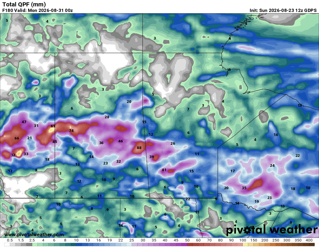
This is a “few active days, several quiet days” week — not a soaker, but enough moisture in spots to matter for fieldwork timing. Harvest continues under a generally active but not saturated pattern this week. A trough digging across Alberta develops into a low over central Saskatchewan early in the period, dragging rain and a few strong-to-severe thunderstorms across the western Prairies through Monday and Tuesday. Behind it, a milder ridge builds for the middle of the week, followed by renewed thunderstorm and heat chances late in the period as warmth rebuilds over the south. A cooler signal tries to nose into the northwest by the very end of the outlook, hinting at an early taste of fall as August turns to September. The map below shows total rainfall expected until Sunday night. Most of it will fall across the central Prairies, and southern Alberta is likely to remain dry:

Alberta’s moisture divide remains the defining story, with the South and Central regions running hot, dry and well ahead on harvest while the Peace and Central regions carry excess moisture and lag behind. Saskatchewan harvest sits well behind average (roughly 4% complete provincially) after weeks of on-and-off showers, with the southwest leading. Manitoba harvest is more advanced with winter cereals and barley well underway, though recent heavy rain and wind in the Interlake caused notable crop damage.
Monday
Peace Region
Quiet to start. Trailing moisture and cloud from the weekend system, but no organized threat listed for Monday itself. Fields remain soft in spots from excess moisture — any additional rain is unwelcome for producers still trying to get on wetter ground. For them, Monday’s dry weather is good news. It will be warm, too, with temperatures climbing to the mid-20s.
Alberta
Morning rain and thunderstorm risk across central Alberta, spreading into eastern Alberta. A surface low is forecast to organize over central Saskatchewan through the day, with strong northwest winds (gusts to 70 km/h) developing on its western/backside flank into eastern Alberta. East-central Alberta likely sees 25–50 mm of rain, locally more in storms. This lands in a region where Central Alberta crops are rated well above average (70% good-to-excellent) and pea/cereal harvest was just getting underway. A soaking rain and gusty winds could stall swathing and raise lodging risk right as combines were set to roll. Behind the departing rain, temperatures will rise to the low to mid-20s.
Saskatchewan
Morning thunderstorm and rain threat across central Saskatchewan, with a humidex and hot-temperature threat over western Saskatchewan ahead of the low-pressure system developing in central Saskatchewan. Afternoon rain and thunderstorm risk expands as the low strengthens during the day. Expect a mix of beneficial rain for later-seeded, still-filling crops and localized heavy downpours/strong wind gusts that could flatten anything close to maturity. With provincial harvest still lagging (around 4% complete versus a 10-year average near 12%), timing of this rain is as much a mixed blessing as it is unhelpful for producers hoping for a dry window to get started. South of the Trans-Canada Highway, high temperatures will reach the mid-20s. North of the highway, expect high teens and low 20s.
Manitoba
Afternoon rain risk reaches southwestern Manitoba as the Saskatchewan system’s leading edge arrives. Manitoba harvest has been more advanced (winter wheat, fall rye and barley well underway), so additional rain risks slowing the drying process and delaying the next round of swathing in the southwest. Toward late afternoon and evening, the rain reaches the rest of southern Manitoba and may fire up some thunderstorms, causing delays in the harvest there. Across the province, highs will reach the high teens or low 20s.

Tuesday
Peace Region
It’s another quiet day in the Peace Region, with plenty of sunshine and no chance of rain. It’s a great opportunity to get some fieldwork done, and perhaps begin the harvest, if the time is right. Highs will reach the 26 to 28 degree range. It’ll be a good test of the air conditioning in the combine.
Alberta
A pre-dawn chance of rain continues in east-central Alberta as the departing system wraps up its moisture. By sunrise, the rain will have moved into Saskatchewan, leaving behind some clouds, which will clear in the afternoon. The rest of the province will be sunny throughout the day, as a large area of high pressure strengthens over Alberta. A wind gust threat is flagged for southeastern Alberta as northwesterly flow behind the low tightens the pressure gradient. Southern/southeastern Alberta, already the driest part of the province, at least avoids the heaviest rain, picking up gusty, drying winds instead. Highs across Alberta will reach the low to mid-20s, except for areas south of the Trans Canada Highway. There, highs will reach the high 20s.
Saskatchewan
A morning rain and thunderstorm threat continues in central Saskatchewan, with a wind gust threat for southwestern Saskatchewan as the low pulls away to the east. By the end of the day, most areas will clear out, except for southeastern Saskatchewan, where the rain remains. This continues the pattern of scattered but not uniform moisture — some areas may see further rain totals build, while the driest southwest gets wind more than rain. Across the province, highs will reach the low to mid 20s.
Manitoba
Morning rain and thunderstorm risk shifts into the Interlake and southern Manitoba as a low-pressure system tracks through. Initially, the rain will affect areas north of the Trans Canada Highway, but it will spread south toward the US border as the day goes on. An afternoon thunderstorm threat continues in southeastern Manitoba. Given the Interlake has already reported significant storm-related crop damage this month, any additional thunderstorm activity here bears watching for wind and hail impact on crops nearing harvest. Highs will be in the 19 to 21 degree range.
Wednesday
Peace Region
This has been quite a week for the Peace Region, and Wednesday will be another quiet, sunny day. That said, a low-pressure system will form northeast of Prince George during the afternoon and may cause enough instability to trigger some afternoon showers near Fort St. John and Dawson Creek. Those showers may cross over into the Alberta Peace during the evening. Rainfall totals will be under 5 mm. It will be warm, with afternoon temperatures reaching the high 20s.
Alberta
High pressure remains in place, so expect sunny weather in all regions all day. A hot-temperature threat develops in the afternoon for southeastern Alberta as the ridge rebuilds. This is good harvest weather for the South Region, which is already leading the province in both crop condition and harvest progress, though it adds to an already-drying soil moisture profile there. An upslope flow, however, may generate some afternoon storms over the southern foothills, especially south of Pincher Creek. These storms should stay non-severe and are not expected to expand beyond the immediate area. It will be hot, with highs ranging from 29 to 31 across southern Alberta, and the mid-twenties elsewhere.
Saskatchewan
Showers or rain are likely in southeastern Saskatchewan during the morning, but by noon, the moisture will have either fizzled out or moved onto southern Manitoba. High pressure builds in behind the rain, clearing the sky and producing a warm afternoon. Highs will reach the high 20s in southern Saskatchewan, and the low to mid 20s elsewhere in the province. A break in the active pattern that should allow harvest equipment back into fields province-wide, particularly welcome given how far behind average the provincial harvest pace remains.
Manitoba
After some early-morning showers in southern Manitoba move into Ontario, it becomes a dry, workable day. It’s a good chance to advance harvest of winter cereals, barley and early peas, and to let recently rain-soaked fields (especially in the southwest and Interlake) firm up. The early-morning showers will leave less than 5 mm of fresh moisture on the ground, which will hopefully disappear quickly in the afternoon sun. Highs will reach the low 20s.
Thursday
Peace Region
An afternoon thunderstorm threat develops as a ridge/trough interaction brings convection back to the north. This is worth watching for producers in the Peace who are already behind on both moisture management and harvest progress (Peace Region crop yields are running about 9% above average, but the region remains among the wettest and least-advanced on harvest). The bigger rain threat will be in the Alberta Peace. The BC Peace is likely to be quieter. This change in the weather pattern includes lower temperatures, with highs in the 16 to 21 degree range.
Alberta
Hot-temperature risk continues both morning and afternoon for southeastern Alberta and expands to include central and northern Alberta foothills for afternoon thunderstorms. The heat continues to favour rapid fieldwork in the South, though it further stresses topsoil moisture that has already been declining there. It will be hot south of the Trans Canada Highway, with highs exceeding 30 degrees. In central and northern Alberta, expect highs in the 24 to 27 degree range.
Saskatchewan
Hot-temperature threat extends into southwestern Saskatchewan by the afternoon, alongside the ongoing heat in southeastern Alberta. Highs in this area will reach the 28 to 30 degree range. Good drying and harvest weather for the southwest, which has been the province’s harvest leader, but adds heat stress for later-maturing crops still filling in central and eastern districts. With high pressure remaining, you can expect a bright, sunshiny day across Saskatchewan.
Manitoba
No threats specifically flagged for Manitoba Thursday; harvest activity should continue to advance under improving conditions following the midweek break. Expect plenty of sunshine, with highs ranging from 18 to 21 degrees, and perhaps as high as 23 near Brandon.
Friday
Peace Region
No threats listed for the Peace itself, though the broader late-day Alberta thunderstorm risk sits just to the south. Some cooler air will come in on a northerly circulation around a low forming in northern Alberta, so highs will be limited to the 18 to 20 degree range. Very comfortable for outdoor work.
Alberta
There is a morning thunderstorm risk for central and northern Alberta and near the US border in the south. A Hot-temperature threat continues for southeastern Alberta into the afternoon, joined by southwestern Saskatchewan. A split pattern persists. And that will lead to some active afternoon showers and storms with convection in the north and central regions, while heat and dryness hold firm in the south. The greatest chance for meaningful showers and storms will occur between Calgary and Edmonton in the evening. Highs in central and northern Alberta will range from 18 to 23 degrees. In the south, it will likely warm up to the high 20s.
Saskatchewan
Hot-temperature threat expands to southwestern and, by afternoon, southern Saskatchewan generally. The heat will generate a thermal low, which could trigger some showers in the afternoon across southern Saskatchewan. Any showers that form will be light, and widespread heavy rain is unlikely. Overall, it will, for many areas, continue to be good harvest weather, though building heat will add pressure to already-tight topsoil moisture reserves across the southern grain belt. Afternoon highs could reach the 30s across the south. Elsewhere in Saskatchewan, highs can be expected to reach the low to mid-20s.
Manitoba
Friday will be another sunny day across Manitoba, with no significant weather expected. Highs across the province will range from 18 in the north to 21 in the south.
Saturday and Sunday
Peace Region
A morning wind gust threat develops Saturday as flow tightens ahead of the next northern system. Producers should watch for lodging risk in any standing crop, with swathing operations facing added hazards. The Peace then falls within a broader central and northern Alberta rain threat both Sunday morning and afternoon. Wet ground continues to be the main limit on fieldwork. Highs both days will range from 18 to 20 degrees.
The map below shows rainfall expected over the weekend, and central Alberta is in for some wet weather:

Alberta
An afternoon rain threat returns to central Alberta Saturday as the next system arrives, while it remains hot in southeastern Alberta both days. Rain continues both morning and afternoon Sunday across central and northern Alberta, with a wind gust threat added for central Alberta that afternoon. The moisture divide reasserts itself all weekend: more rain for an already-wet north, more heat and dryness for an already-dry south. Outside of the hot weather in southeastern Alberta, Saturday’s highs elsewhere will reach the high teens and low 20s. On Sunday, it’s cooler, with most regions staying below 20 degrees.
Saskatchewan
Hot weather continues in southwestern Saskatchewan through Saturday morning, broadening to southern Saskatchewan generally by afternoon as heat builds ahead of the next Alberta system. Areas of rain develop Saturday across central and southern Saskatchewan, and on Sunday, that rainfall will organize into a well-developed low-pressure system near Meadow Lake. Rain will intensify east and south of the low, along the Manitoba boundary. This is not going to be a great weekend for fieldwork in Saskatchewan. As the map above shows, the rain will be widespread. Highs will be in the high teens and low 20s.
Manitoba
An afternoon rain threat reaches Interlake Manitoba on Saturday and will intensify across southern Manitoba on Sunday. Check the map above for expected weekend totals. Given recent storm damage in that district, any further rain will be closely watched. Even without severe storms attached, it could still affect standing and swathed crop. Areas still working through storm-damaged or lodged crop should benefit most.
EVENT FORECASTS
Alberta Barrel Racing Association Finals, August 24-30, Ponoka, AB
August 24 – A few clouds in the morning, sunny in the afternoon, breezy, high 21
August 25 – Sunny, high 23
August 26 – Sunny, high 26
August 27 – A few clouds, high 27
August 28 – Increasing clouds, chance of afternoon showers, high 20
August 29 – A mix of sun and cloud, chance of afternoon showers, high 21
August 30 – Morning showers, afternoon clearing, quite windy, high 16
Heritage Harvest Field and Festival, August 29, Austin, MB
August 29 – Mainly sunny, chance of light, scattered afternoon showers, high 27
READ: Hail Report: With Harvest Underway, Farmers Continue to Deal with Crop Damage
The post Prairie Weather This Week – August 24 first appeared on Rural Roots Canada.