
Prairie Weather This Week – July 6
This post was originally published on this site.


Prairie Weather (Rural Roots Canada) – Hot weather finally arrives in the southern prairies, as the thunderstorm risk persists.
It is Stampede Week in Calgary, and if you’re looking for a weather outlook for the Calgary Stampede, you’ll find it at the end of this post, along with forecasts for events in Olds, Alberta, and Carman, Manitoba.
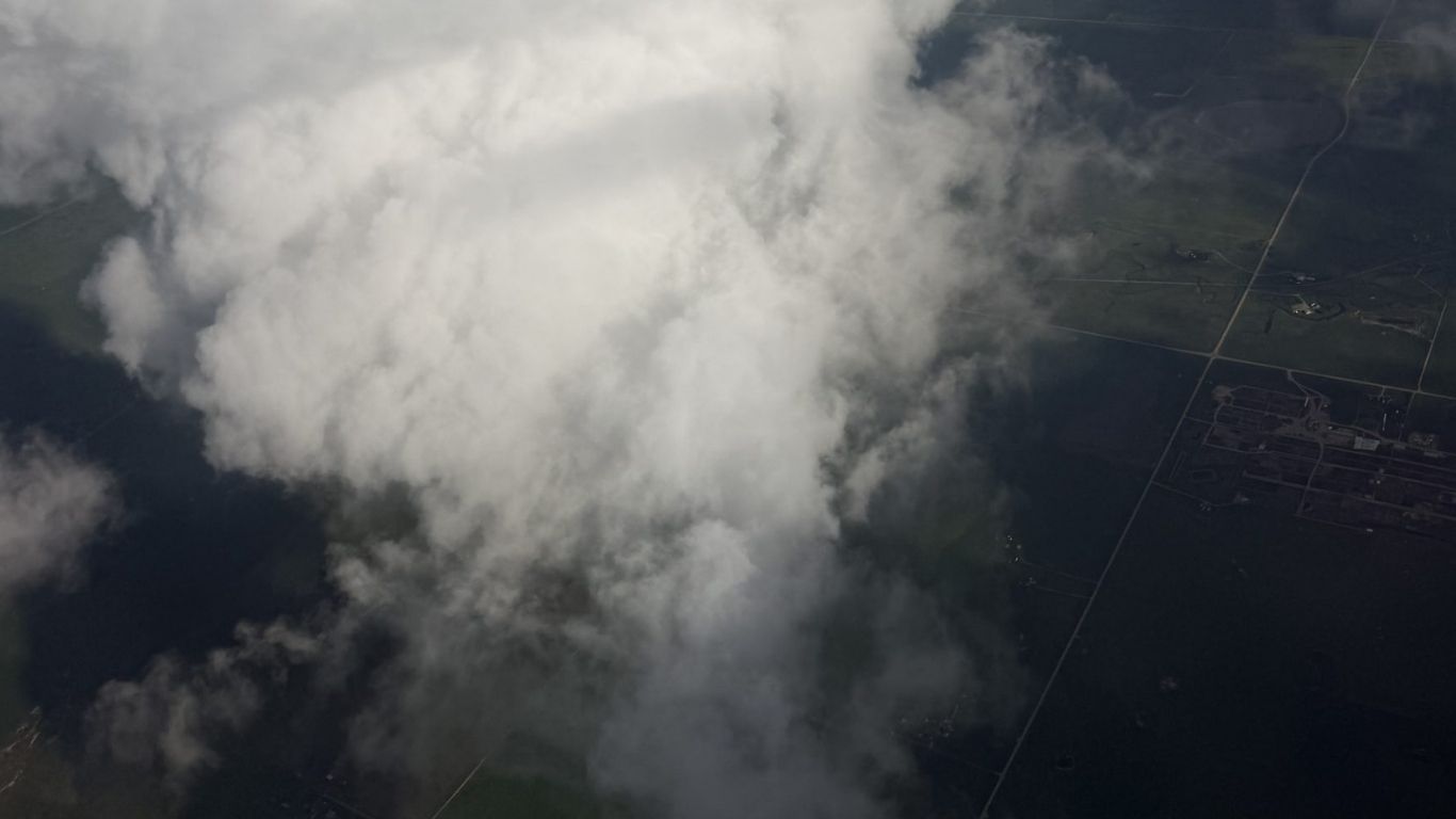
This photo below perfectly encapsulates what we’ve been going through across the prairies for the past few weeks, and what we can expect in the week ahead:

The photo was taken last week during a flight over Saskatchewan. Isolated thunderstorms like that will continue to pop up across the prairies in the days ahead, and some will be severe, with the risks of hail and tornadoes. The random nature of these storms makes it almost impossible to accurately forecast timing and location, so it remains wise to consult Environment Canada’s warnings as we go through the next week.
The big system responsible for last week’s severe weather outbreak is finally moving out, but it is not going quietly. Monday brings one more round of significant storms before a brief mid-week improvement arrives. After that, another active period builds through Thursday and runs through the weekend, keeping the thunderstorm threat in play across all four regions through most of the week. Temperatures warm considerably compared to the cool pattern of recent weeks, with heat building over southern Saskatchewan and Manitoba Thursday through the weekend. For producers, the story is clear: Tuesday and Wednesday are your windows. Use them.

Saskatchewan seeding is now 97% complete, and crop conditions are rated mostly good to fair province-wide. Canola comes in at 22% excellent and 67% good, which is solid given the late and disrupted spring. The challenge now shifts from getting the crop in the ground to keeping it there. Repeated rainfall, persistent cloud cover, and slower-than-normal heat unit accumulation through June are the concerns heading into the critical mid-summer growth period.
The two maps below show rain expected until the evening of Sunday, July 12. Compared to the past couple of weeks, it will be drier in most areas, with pockets of heavier precipitation in the northern prairies and Manitoba’s Interlake. Parts of southern Saskatchewan could receive more than 30 mm this week. And, in Alberta, south of Highway 3, a break in the rain will allow heat to develop and crops to grow.


Monday
Peace Region
A thunderstorm threat is in place across the Peace Region Monday, and the sky should be carefully watched in the afternoon. High pressure is in place, and with considerable moisture in the area, foggy conditions are likely in the early morning and then again overnight. Temperatures recover to near seasonal levels in the 20 to 23 degree range. Get any field assessments done early Monday. Afternoon heat and a moist airmass could cause convection to build again later in the day.
Alberta
The departing system keeps Alberta active Monday. Though high pressure moves in and provides clear weather to start the day, don’t be fooled. A thunderstorm threat exists for southern Alberta, where conditions remain sufficient for organized cells. The afternoon sees the thunderstorm threat shift to northern and east-central Alberta. Humidex values will be notable across the southeast. If you have spray work waiting in central Alberta, Monday afternoon starts the transition, but Tuesday is your real window. Highs Monday will reach 21 to 23 degrees across the province.
Wildfire smoke is spreading south into Alberta from the Northwest Territories as flow shifts to more northwesterly. Air quality warnings may extend into northern Alberta through the day. Check AQHI+ before working outdoors in areas north of Highway 16.
Saskatchewan
Monday carries a severe thunderstorm threat across southern Saskatchewan through the early morning (before sunrise), with very strong storms possible through much of the province. This is the tail of a multi-day outbreak, not a fresh start. Instability is still real. Check Environment Canada’s active watches before heading out. The afternoon sees a much reduced thunderstorm threat across the province. Much reduced – but not zero. Humidex values rise in the south. Highs in Saskatchewan will reach the low 20s.
Manitoba
The province carries a severe thunderstorm threat Monday morning, with very strong storms possible, particularly in southern areas. Sunday’s outbreak produced supercells over western Manitoba. Residual instability and the trailing cold front keep the threat alive Monday morning. Humidex warnings are possible for southern Manitoba and the Interlake. By afternoon, the threat gradually eases from west to east.
Wildfire smoke from northern Manitoba fires begins spreading south into central Manitoba on northerly winds developing behind the passing low. Monitor AQHI+ values in central areas through the day. It will be a cooler-than-average day, with highs remaining in the teens for most of the province. In and east of the Red River valley, temperatures are more likely to rise into the low 20s.
Tuesday
Peace Region
Conditions improve Tuesday. A mix of sun and cloud, temperatures warming to the mid-to-high 20s, will make this a warm and mainly sunny July day. There is no significant organized storm threat for the region. This is your first clean field day of the week. Get herbicide passes moving.
Alberta
Most of central and northern Alberta sees a mix of sun and cloud with a reduced but not zero thunderstorm threat. Southeastern Alberta carries a hot temperature threat throughout the day, with temperatures closing in on 30 degrees. Temperatures will reach the mid to high 20s across the rest of the province. While few areas are likely to see any rain Tuesday, the morning hours are your best spray window before any afternoon convection builds. The map below shows there will be significant energy for thunderstorms in the southern half of the province.

Overall, Tuesday is a significant improvement over Monday for most of the province. To clarify, stating a thunderstorm threat is not the same as a forecast for thunderstorms. It only indicates there are conditions that make storms possible.
Saskatchewan
As the map above shows, a thunderstorm threat covers far western Saskatchewan through the day, with the highest risk near the Alberta boundary. Central and northern Saskatchewan are largely clear. If your operation is north of the Trans-Canada, Tuesday is a legitimate field day. Work the morning before heating builds. Southern areas, particularly the southwest, stay more active through the afternoon. In areas where rain and storms develop, high temperatures will remain in the mid to high teens. Elsewhere, expect highs in the low to mid-20s across Saskatchewan.
Manitoba
It will be a rather quiet day in Manitoba, with no significant weather expected. A system will bring heavy rain to North Dakota, sending clouds into southern Manitoba and the southern Interlake, but the moisture should stay south of the border. Highs across the province will reach the low 20s, except for the Brandon area, where it will be a bit cooler as highs only reach the 17 to 20 degree range.
Wednesday
Peace Region
A surface low-pressure system develops early in the morning near the town of Peace River and moves northeastward throughout the day. The system will produce rain, ending the streak of a few relatively dry days. Most of the Peace Region will get between 0 and 5 mm of rain, though areas on the southern and northern fringes of the Peace could see double digit accumulations. With the wet weather, high temperatures will be held to the mid-teens. There is a slight chance of afternoon thunderstorms, though unlikely.
Alberta
A low pressure system develops in northwestern Alberta, generating instability across the northern part of the province and along a warm front south along the Saskatchewan boundary. The heaviest rain will fall in northern Alberta, mainly in the large area between Peace River and Fort McMurray. A thunderstorm threat remains, with stronger storms possible in central Alberta in the afternoon.
The wind gust threat between Edmonton and Grande Prairie Wednesday afternoon is worth noting if you are running wide implements or have tall crops in that corridor. Southeastern Alberta carries a hot temperature threat, with highs potentially reaching 30 degrees or more near the US border. And that heat may also generate some afternoon instability. Get your spray work done in the morning before afternoon heating and convection build.
Saskatchewan
Rain is possible in southeastern Alberta and southwestern Saskatchewan throughout the day, especially toward afternoon and evening. A thunderstorm threat covers western Saskatchewan in the morning. The hot temperature threat along the Alberta-Saskatchewan boundary south of Lloydminster intensifies through the day. East of Saskatoon, conditions are largely clear with temperatures in the mid-to-upper 20s. Wednesday is a strong candidate for in-crop herbicide passes in central and eastern areas. If your canola needs treatment, this is your window before the next active period arrives Thursday.
Manitoba
Another uneventful weather day is expected for Manitoba. The sky should remain mainly sunny as temperatures climb to the mid-20s in the afternoon. The possibility of instability-related showers and non-severe thunderstorms is ever present, but such weather appears quite unlikely on Wednesday. Nonetheless, southern and central Manitoba have a reasonable morning window before afternoon convection develops. Watch the sky in the afternoon – just in case.
Thursday
Peace Region
The active pattern returns. A rain threat covers the northern half of Alberta and extends into the Peace Region, though the threat to the Peace is much less than to northern Alberta. Wind gusts are a concern across the Peace area. The overall risk builds through the day. Thursday could be a limited field day in the Peace Region, though the greatest likelihood is for brief showers and little accumulation. Temperatures will reach the high teens, and climb to the low 20s if the rain holds off and it stays dry.
Alberta
A significant rain threat sits over the northern half of the province through the morning and afternoon. Thunderstorms cover all of Alberta, with the strongest activity in east-central areas in the morning. Wind gusts are a concern across central Alberta and the Peace Region in the morning and through central and northern areas in the afternoon. The foothills carry an elevated threat in the afternoon. A hot temperature threat intensifies along the Alberta-Saskatchewan boundary, and southeastern Alberta is under a hot temperature threat for the second consecutive day. Plan to be done with outdoor operations by noon in most areas.
Saskatchewan
The entire province carries a thunderstorm threat Thursday morning and afternoon. The strongest activity is in the western half, moving to southeastern Saskatchewan. The map shows the thunderstorm threat is strongest in southeastern regions in the late afternoon:

A humidex threat develops in southwestern Saskatchewan, and a hot temperature threat covers southern areas, where temperatures could reach as high as 30. Wind gusts are expected in central Saskatchewan through the afternoon. A rain threat extends across northern Saskatchewan in the afternoon. Wrap up field operations by noon across the province. Central and eastern areas have a slightly later window, but afternoon convection will be province-wide.
Manitoba
As the above map shows, the afternoon thunderstorm threat extends into the eastern half of Manitoba and the Red River Valley. Heat and humidity continue to build across the south. If you have cattle on pasture in southern Manitoba, check water sources today. The combination of heat and humidity increases the risk of heat stress in cattle at temperatures that might not trigger concern in dry conditions. Afternoon temperatures will reach the mid to high 20s.
Friday
Peace Region
A rain threat continues in the BC Peace region through the day, though the Alberta side should stay dry. That said, stray thunderstorms can’t be ruled out. The strongest afternoon storms will likely form in the foothills to the south, but an isolated banger or two can’t be ruled out for the Peace. Accumulations of rainfall will be minimal. Expect highs in the 20-22 degree range. Friday may not be a productive day in the Peace Region. We will know more in Thursday’s update here at Rural Roots Canada.
Alberta
The morning carries a rain threat in northern Alberta, with thunderstorms across central and southern areas. The foothills are again the zone of highest risk. A hot temperature threat covers southern Alberta south of Highway 3. From Lethbridge east, temperatures will reach the low 30s. Across the rest of the province, expect highs in the low to mid 20s. Wind gusts are a concern in the northern half of the province. Throughout the day, it’s the same picture: rain in the north, province-wide thunderstorms, and the strongest activity along the foothills.
Saskatchewan
A thunderstorm threat covers the entire province Friday morning and afternoon. The strongest morning storms are concentrated in a broad zone bounded roughly by Regina, Neepawa, and Portage la Prairie, which takes in most of central and eastern Saskatchewan. Storm energy values are particularly high south of Regina, and while it’s too early to make any specific predictions, severe weather appears likely.
A humidex threat covers southeastern areas through the day. Heat warnings are expected south of Highway 1. Temperatures across the southern half of Saskatchewan will reach the high 20s or low 30s. Wind gusts are a factor in western Saskatchewan. Canola approaching the pod-filling stage is vulnerable to heat stress when temperatures stay above 29 degrees for extended periods. Know what growth stage your canola is at heading into this hot stretch.
Manitoba
A thunderstorm threat covers northwestern and southern Manitoba through the morning, intensifying through the afternoon. The strongest afternoon storms are in southeastern Saskatchewan and southern Manitoba. Humidex conditions in southern Manitoba intensify Friday. The Brandon-to-Winnipeg corridor has repeatedly been an active storm zone this week. Stay weather-aware through the afternoon and evening. Temperatures across southern Manitoba will reach the high 20s. Central Manitoba’s highs will be in the low to mid 20s, and in the north, 20 degrees is unlikely to be reached.
Saturday
Peace Region
A thunderstorm threat develops in the morning and intensifies in the afternoon, with a wind gust threat in the Grande Prairie area. The afternoon carries a rain threat from northern Alberta toward Cold Lake and Lloydminster, and a province-wide thunderstorm threat. Not a field day for the Peace Region, where most of the shower and storm activity can be expected in the afternoon hours. Because the showers and storms will be short and isolated, significant rainfall accumulation is not expected. Highs will be in the high teens or low 20s.
Alberta
Thunderstorms are in the forecast for all of Alberta Saturday morning and afternoon. The strongest southern storm activity avoids the area west of Bow Island and south of Claresholm. Wind gusts are expected near Crowsnest Pass and Pincher Creek in the morning, and near Cold Lake and Lloydminster in the afternoon. Hot temperature conditions persist across the southern half of the province. From Brooks south to the US border, temperatures will reach the mid-30s. Elsewhere, expect highs in the mid 20s. If you farm near Crowsnest Pass or the southern foothills, secure loose equipment before the morning wind picks up.
Saskatchewan
Thunderstorms are possible across the province Saturday morning and afternoon, with the strongest threat in southeastern Saskatchewan. Humidex values will be high in southeastern areas. Heat warnings can be expected across the southern half of the province. South of the Trans Canada Highway, afternoon high temperatures will exceed 30 degrees. Elsewhere, expect highs in the mid-20s. Crops in the pod-filling and grain-filling stages need adequate moisture. Areas that have been missed by recent storm cells while sitting under sustained heat are accumulating thermal stress.
Manitoba
The strongest afternoon thunderstorms of the week for Manitoba occur Saturday, concentrated in the southern third of the province. Humidex conditions are at their most intense through the weekend. Heat warnings can be expected for the southern half of the province. Check cattle water sources. Heat stress in cattle can set in at 25 degrees when humidity is high, well below what you might expect on a dry day. In most of agricultural southern Manitoba, highs will reach the low 30s, and it will feel even warmer and muggy, with high humidity.
Sunday
Peace Region
A thunderstorm threat carries into Sunday with gusty winds in the Grande Prairie area. Throughout the Peace, highs will reach the high teens or low 20s, but exact values will depend on where the showers and storms pop up. Conditions are unsettled throughout the day, and there is the potential for strong, perhaps severe storms, especially near Dawson Creek and Fort St. John. Once again, rainfall amounts will be minimal, most likely under 5 mm overall. That said, areas caught right beneath storms may receive more.
Alberta
Sunday morning brings a rain threat near Calgary and in the Wood Buffalo area, with a province-wide thunderstorm threat. Wind gusts are expected in southern Alberta and central Saskatchewan in the morning. The afternoon carries rain in south-central Alberta with thunderstorms province-wide and continued wind gusts in the south. Heat warnings are possible across southern Alberta, as afternoon temperatures climb to the mid-30s. Highs elsewhere will reach the high 20s, falling just short of heat warning criteria. Sunday is the last day of the active stretch before the week’s main disturbances push east.
Saskatchewan
Sunday will be a scorcher in southern Saskatchewan as highs could reach the 34 to 38-degree range. A province-wide thunderstorm threat runs through Sunday morning and afternoon, with very strong activity expected in the south. Wind gusts are expected in central Saskatchewan through the morning. Humidex values remain elevated in the south and southeast. All this is fuel for severe weather. This is not a forecast, but a heads-up. If you’re reading this early in the week, you have plenty of time to prepare as best you can for what’s coming.
The hottest weather and most volatile conditions will extend northward to Saskatoon. Beyond that, there is still a threat of storms, but they are less likely to be as severe as those in the south. By late Sunday, the main disturbances push into Manitoba and conditions begin to ease across western and central areas heading into next week.
Manitoba
Sunday carries a strong thunderstorm threat across southern Manitoba, with the most active zone between Brandon and Winnipeg south to the US border. Humidex values peak in that corridor. Wind gusts are expected in western Manitoba and the Interlake through the day. Severe thunderstorms are possible in southern Manitoba Sunday afternoon given the heat, humidity, and forcing in place. Monitor Environment Canada’s severe weather watches closely. Do not plan extended outdoor operations in southern Manitoba Sunday without a plan to take shelter. Afternoon temperatures will reach the high 20s across Manitoba, including the far north.
EVENT FORECAST
Calgary Stampede
July 6 – Sunny, wind gusting to 30 km/h, high 23
July 7 – Sunny, wind gusting to 30 km/h, high 27
July 8 – A mix of sun and cloud, wind gusting to 40 km/h, high 27
July 9 – A mix of sun and cloud, high 25
July 10 – A few clouds, high 27
July 11 – Sunny, high 28
July 12 – Some sun with cloudy periods, high 27
Summer Synergy – July 6-8, Olds, Alberta
July 6 – Sunny, high 23
July 7 – Sunny, windy, high 27
July 8 – Increasing cloud, afternoon thunderstorms, high 25
Carman Country Fair – July 9-11, Carman, Manitoba
July 9 – Mainly sunny, wind gusting to 30 km/h, high 26
July 10 – Morning rain, afternoon sun, high 29
July 11 – Increasing cloud, afternoon showers or thundershowers, high 30
COMPARE: Prairie Weather This Week – Midweek Update July 2
The post Prairie Weather This Week – July 6 first appeared on Rural Roots Canada.