Prairie Weather This Week – June 15
This post was originally published on this site.


Prairie Weather (Rural Roots Canada) – Stormy weather returns to the prairies, with unwelcome rainfall.
This week delivers another saturated setup. An active upper-level trough remains entrenched over the prairies, and a series of shortwaves and developing surface lows will keep the threat of showers and thunderstorms in the forecast every single day of the outlook period. The severe threat is not confined to one or two days. It is present Monday through Sunday, moving from region to region with each passing disturbance. Keep Environment Canada’s alert page bookmarked all week and check it every morning before planning field operations.


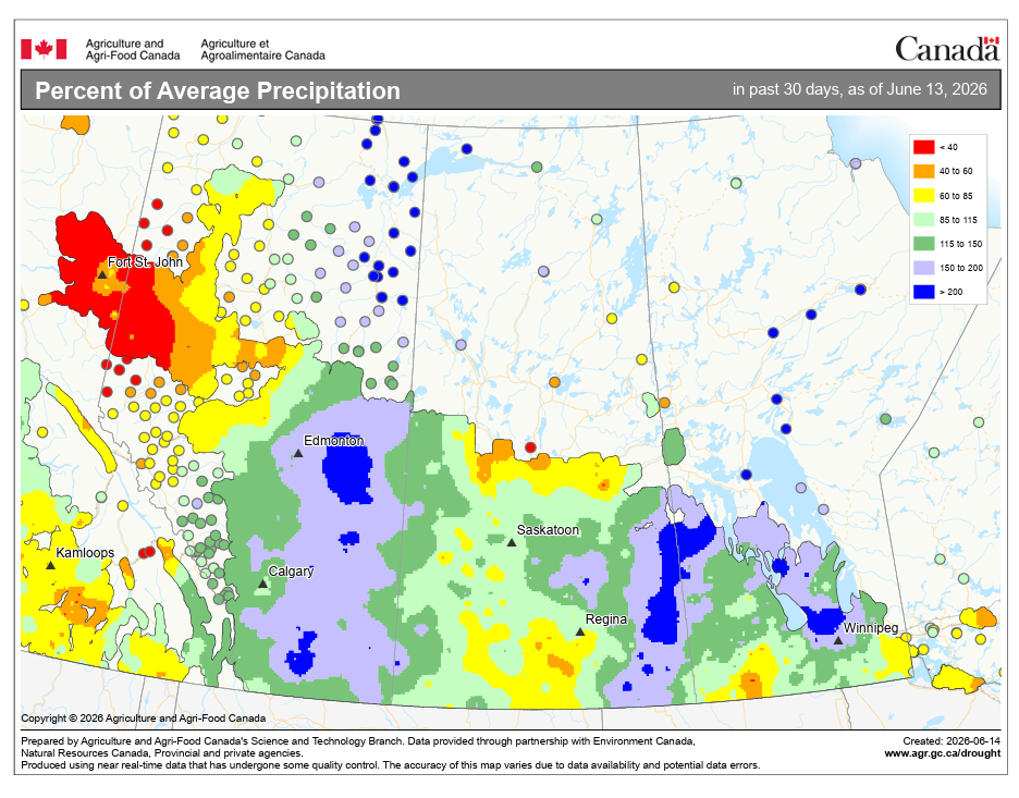
The rainfall this week won’t be welcome. Since June, there has been ample rain across the prairies. The map below shows the percentage of normal rainfall since June 1. In the gray shaded areas, there has been 150 – 200 percent of normal rainfall, and in the blue shaded areas, it’s greater than 200 percent:

The agricultural picture is improving where the crop is in the ground. Saskatchewan topsoil moisture is rated 82% adequate, 8% surplus, with very little short or very short. Manitoba spring wheat seeding reached 88% complete, with the earliest fields already at the two to three leaf stage. The concern now shifts to crops still finishing emergence on late-seeded fields in the northeast and east-central, and to the cumulative effect of additional rainfall on fields already carrying adequate to surplus moisture. More rain this week is not universally welcome. Flooding in low spots, root disease pressure in waterlogged soils, and continued delays to herbicide applications are all real risks. Work your spray windows hard when they open.
Monday
Peace Region
High-pressure ridging in from BC keeps the Peace largely dry on Monday. Conditions are settled through the day with a mix of sun and cloud and highs in the low-to-mid 20s. A surface trough associated with a developing low in the NWT will push clouds in late Monday, and showers become possible overnight in the northern Peace. Take Monday seriously as a spray day. It is likely the cleanest day of the week for the Peace Region.
Alberta
A similar story across most of Alberta on Monday. The BC ridge holds fair weather through the afternoon before a surface trough from the NWT low brings clouds and possible showers Monday night into Tuesday. Showers are likely across much of northern Alberta on Monday, except for the northeast corner. Severe thunderstorms are possible across northern Alberta on Monday afternoon. Southern and central Alberta see a quieter day with mostly dry conditions through the afternoon. Highs will reach the mid-20s across the province. If you have herbicide passes waiting, Monday morning to early afternoon is your window across central and southern areas. Keep an eye on the northern horizon if you are working north of Highway 16.
Saskatchewan
Scattered showers or thunderstorms are possible in central and southeastern Saskatchewan on Monday. The environment will support convection through the afternoon, and any storms that develop could produce hail and brisk wind. Expect highs in the low to mid-20s. Central Saskatchewan producers should wrap up field operations by early afternoon and watch the sky. Conditions in northern and western Saskatchewan are quieter, with the main threat tracking across the central and southeastern portions of the province.
Manitoba
Southwestern Manitoba is in the path of Monday’s thunderstorm threat, with the activity tracking in from Saskatchewan during the afternoon and evening. Any storms that develop will likely stay below warning criteria. Central and eastern Manitoba stay largely out of the main threat area on Monday, with partly cloudy skies and no significant precipitation. Highs will only reach the low 20s in southern Manitoba, and will stay below 20 degrees in central and northern regions. Scout your southwestern fields in the morning and have equipment secured before the afternoon storm window opens.
Tuesday
Peace Region
A surface low developing over southern Alberta and the trough pushing south from the NWT combine to bring the Grande Prairie area into a severe thunderstorm threat Tuesday morning. This is worth taking seriously. Storms near Grande Prairie in the morning hours can move quickly and produce large hail. Temperatures will remain in the mid-teens throughout the day. If you have livestock in the open or equipment in exposed areas, get things secured before sunrise Tuesday. Afternoon conditions may improve briefly before the next round of activity develops.
Alberta
Tuesday is the most complex day of the week for Alberta. Widespread showers are expected across the province, extending south from Monday night’s activity. A band between the northwest corner and Cold Lake could see 30mm or more, with locally higher amounts to 50mm from convective activity. Outside that corridor, less than 10mm is forecast for most areas. The map below shows Tuesday’s expected rain in BC and Alberta:

A surface low develops over southern Alberta through the day, driving a severe thunderstorm threat across all of Alberta and western Saskatchewan through the afternoon. The foothills and south of Highway 3 face an additional wind gust threat. Gusts in those areas could exceed 90 km/h with stronger storms. Northern Alberta carries the severe morning threat near Grande Prairie, while the afternoon risk spreads province-wide. There is no clean field day to be found in Alberta on Tuesday. Focus on scouting drainage in low-lying fields and checking emerged crops for flooding stress.
Saskatchewan
After a quiet morning, by Tuesday afternoon, a severe thunderstorm threat expands into western Saskatchewan as the Alberta low and its associated trough push east. If your fields are in western Saskatchewan and you were hoping to spray on Tuesday, the afternoon is likely off limits. Temperatures will reach the high teens or low 20s across Saskatchewan, but the west will cool off as the afternoon showers and storms move in. The showers will expand toward central Saskatchewan in the evening. Morning hours in the west are your better window, but watch the radar closely. Rainfall accumulating through Tuesday in western Saskatchewan could tip some fields that were already at adequate moisture into surplus territory.
Manitoba
In contrast to the stormy conditions to the west, Manitoba will have a quiet day with a mix of sun and cloud. Afternoon temperatures across the south will reach the low to mid 2os, with slightly cooler weather in the Interlake. Central and eastern Manitoba stay mainly dry on Tuesday with improving skies through the afternoon. This is likely a workable afternoon for Manitoba producers if your field conditions are good. Herbicide applications in central Manitoba could move on Tuesday afternoon.
Wednesday
Peace Region
Wednesday brings the BC Peace and Alberta Peace Region into a more significant weather setup. A morning severe thunderstorm threat is in place for the northern BC Peace and extends into the Alberta Peace Region, with a wind gust threat accompanying the activity. The morning threat is the main concern. Gusts associated with strong cells could exceed 80 km/h. Afternoon conditions carry a continued severe thunderstorm threat across the BC Peace. It will be cool, with highs only reaching the mid-teens. Wednesday is not a field day for the Peace Region on either side of the provincial boundary.
Alberta
Wednesday is the most active day of the week for Alberta and one of the most active of the entire spring. A morning rain threat covers the northern half of the province. A thunderstorm threat covers all of Alberta within 150 km of the BC boundary, along with a wind gust threat for central and southern Alberta in the morning hours. It will be a cool day, with highs across the province in the 14 to 16 degree range. By afternoon, the thunderstorm threat expands to all of Alberta.
Wind gusts are again a concern for central and southern areas in the afternoon. Alberta producers should plan for a full down day on Wednesday. Do not move equipment or work in open fields. Have your livestock secured. Monitor Environment Canada watches and warnings from first light. Alberta is seeing its most active stretch of the spring this week, and Wednesday could be the peak.
Saskatchewan
Morning rain covers the southern half of the province on Wednesday, with a severe thunderstorm threat for western Saskatchewan within 150 km of the Alberta border through the morning. The rain threat also extends into central and southern Saskatchewan and into southwestern Manitoba, with a continued severe thunderstorm threat for southern Saskatchewan.
If you are in western Saskatchewan near the Alberta border, the severe risk is present in the morning and afternoon on Wednesday. Central and eastern Saskatchewan see a rain threat in the afternoon, but a lower severe risk. It will be cooler than average, with highs in most regions reaching the high teens. There is a chance for highs in the low 20s along the Yellowhead corridor between Saskatoon and Yorkton. Check your drainage before heading out.
Manitoba
Southwestern Manitoba carries an afternoon rain threat on Wednesday as the Saskatchewan system pushes east. The severe risk is lower for Manitoba on Wednesday compared to the border regions to the west, but gusty winds and locally heavy rain are possible wherever a stronger cell tracks through. Central and eastern Manitoba stay mainly quiet until late afternoon Wednesday, when a weak Low develops near Grand Beach. That will produce some rain north of Winnipeg toward Seven Sisters and the Ontario boundary. Highs across Manitoba will reach the mid to high teens.
Thursday
Peace Region
Showers or periods of rain are likely throughout the day in the Peace region, with the possibility of some non-severe thunderstorms, particularly in the afternoon. Conditions across the Alberta Peace should be monitored through the afternoon as activity to the south and west may edge northward. Highs in the mid to upper teens.
Alberta
Morning rain is possible in central and southern Alberta on Thursday, while a severe thunderstorm threat is in place for northern Alberta in the morning hours. Should thunderstorms develop, wind gusts will be a concern for central and southern Alberta. By afternoon, the severe thunderstorm threat shifts to the BC Peace and northern and central Alberta. Southern Alberta sees an improving afternoon, as high pressure builds in southwestern Saskatchewan.
North of the Trans Canada Highway, temperatures will rise into the high teens. South of the Trans Canada Highway, expect afternoon temperatures in the low 20s. If you are in the Peace or north of Edmonton, treat Thursday similarly to Wednesday. Southern Alberta producers get a better afternoon window and should move on any remaining spray work.
Saskatchewan
Southern Saskatchewan and southern Manitoba carry both a morning severe thunderstorm threat and a morning wind gust threat along the US border on Thursday. Storms near the border region could produce hail and wind gusts exceeding 90 km/h. The severe environment here will be primed by the humid air that has been drawn north over several days. It won’t be a warm day, as highs will only get to the 16 to 19 degree range. Central Saskatchewan sees a lower storm threat Thursday and may have a workable midday window if Monday and Tuesday’s rain has not left fields too soft. Check before committing equipment to wet soils.
Manitoba
A severe thunderstorm threat covers southern Manitoba on Thursday. The Saskatchewan-Manitoba border zone is again highlighted as an area of concern early in the day. By afternoon, the storm threat moves east toward the Interlake. Heavy rain and thunderstorms are possible in southern Manitoba west of the Red River Valley and north of the Trans Canada Highway in the afternoon. Winnipeg and eastern Manitoba see a lower threat Thursday, until the Low moves toward Falcon Lake in the evening and overnight hours.
With the wet weather, highs across southern Manitoba will only reach the mid-teens. The exception is southeastern Manitoba, which will be on the warm side of the low before it advances toward evening. There, in places like Sprague, temperatures could reach the low 20s.
Friday
Peace Region
The BC Peace carries a morning rain threat and a midday thunderstorm threat on Friday, with a risk of severe storms continuing into the afternoon. The Alberta Peace Region is on the edge of this activity. Watch forecasts closely on Friday morning before heading out. Rain through the day is likely, and heavy rain in the afternoon is possible. Some parts of the Peace may get 20 to 40 mm. As one might expect with this kind of weather, it will be cool, with highs only reaching 12 or 13 degrees.
Alberta
Central and northern Alberta carry a morning severe thunderstorm threat on Friday, with the afternoon risk expanding to all of Alberta. A rain threat sits over the foothills north of the Trans Canada Highway through the afternoon. This is another day where Alberta producers face uncertainty, as any storms that develop will be isolated and scattered. Some parts of central and west-central Alberta could get significant rainfall, while rain will be scarce to the north and south.
There is a good possibility it will stay dry south of the Trans Canada Highway, but afternoon storms there cannot be ruled out. Friday is the fifth consecutive day of thunderstorm risk for much of the province. Hail damage to crops that were previously unaffected becomes a compounding concern as the week progresses. The central Alberta rain will keep temperatures there in the mid to high teens. In southern Alberta, where the chance of rain is much less, temperatures are likely to reach the high 20s. Scout fields after each event to assess any canopy damage before the next system arrives.
Saskatchewan
Central Saskatchewan carries a morning severe thunderstorm threat on Friday that continues into the afternoon. The southern half of the province has seen repeated storm days this week, and any fields that have taken significant hail earlier in the week need to be scouted carefully. Additional hail on already damaged crops can compound losses quickly. If you have crop insurance questions or damage to documents, get out between events with your phone camera and take dated photos. It will likely stay dry south of the Trans Canada Highway, where temperatures will reach the mid-20s. It’s much more unsettled to the north, and cooler weather is expected, with highs in the high teens and low 20s.
Manitoba
The Manitoba Interlake carries an afternoon severe thunderstorm threat on Friday. This is the area of Manitoba most at risk on Friday. Producers in the Interlake region should watch the afternoon sky carefully and have equipment secured by early afternoon. The rest of Manitoba sees a quieter Friday with mostly cloudy skies and a chance of isolated showers. Highs will reach the high teens, except in the Brandon area, where it could warm to the low 20s.
Saturday
Peace Region
A morning severe thunderstorm threat continues for the BC Peace on Saturday, and the rain will continue throughout the day. Temperatures will only reach the mid-teens, and rainfall totals Saturday alone could total 30 to 40 mm from Grande Prairie to Dawson Creek, with lesser amounts closer to Fort St. John. This event is several days away, and as a result, there is very little certainty in rainfall accumulation forecasts. The update posted here on Thursday will provide a better idea of the weekend rain situation in the Peace.
Alberta
Morning rain covers central and south central Alberta on Saturday, with heavier amounts in the afternoon from Jasper to Grande Prairie in the foothills corridor. A severe thunderstorm threat is in place for the BC Peace, all of Alberta, and the Manitoba Interlake through the morning. By afternoon, the severe risk focuses on the Alberta foothills, southern and central Alberta, and southern Saskatchewan, with a wind gust threat along the southwestern foothills.
Rain totals from Jasper to Grande Prairie in the afternoon could be significant given the favoured terrain lift in that corridor. If you farm in the foothills north of the Trans Canada Highway on Saturday, plan for a wet day with potential for 20mm or more locally. It will be another cool day with highs in the mid-teens.
Saskatchewan
South central Saskatchewan carries an afternoon severe thunderstorm threat on Saturday. The activity tracks in from Alberta and intensifies areas through the afternoon and evening. Accumulations of 40 mm are possible on Saturday along the Yellowhead highway, particularly west of Saskatoon. Northern Saskatchewan sees a quieter day with mostly cloudy skies and the chance of isolated showers. Highs will again only reach the teens, though south of the Trans Canada Highway, it could warm to the 20s if less rain occurs.
Manitoba
The Manitoba Interlake carries a morning severe thunderstorm threat Saturday, continuing from Friday’s activity. The rest of the province sees a lower risk on Saturday. If you are in the Interlake, treat Saturday morning the same as Friday afternoon. In the south, especially south of the Trans Canada Highway, temperatures could climb to the low 20s. Elsewhere, it will be cooler. The area most likely to get significant rainfall on Saturday is west-central Manitoba, near Dauphin.
Sunday
Peace Region
The BC Peace has a morning thunderstorm threat and an afternoon severe thunderstorm threat on Sunday. One week’s worth of repeated storm days in the BC Peace and northwestern Alberta reflects how persistently active the upper-level pattern has been. Rainfall totals in the Peace on Sunday could reach 15 to 30 mm, bringing the total for the week to between 70 and 90 mm. Because of the rain, it will be yet another cool day, with temperatures only reaching the mid-teens at best.
Alberta
Rain is expected from Calgary northwest to Jasper through the morning, with a continued rain threat for all of Alberta south of Highway 16 through the afternoon. Snow is possible at higher elevations near Jasper in the afternoon as cooler air wraps around the system. A morning thunderstorm threat covers the foothills and southern Alberta south of Highway 1, with the afternoon risk expanding to all of Alberta. Wind gusts are a concern for southern Alberta through the morning and afternoon.
This is not a field day anywhere in Alberta. If you have livestock in exposed areas near the foothills, bring them in Sunday morning before the heaviest rain arrives. The summer solstice arrives Sunday, but the weather is anything but summery, as highs only reach the mid-teens.
Saskatchewan
A morning rain threat for east central Saskatchewan and a morning thunderstorm threat for southeastern Saskatchewan south of Highway 1 start the day. Wind gusts are expected in west-central Saskatchewan through the morning. By afternoon, central and southern Saskatchewan both carry rain and severe thunderstorm threats, with the wind gust threat continuing in southwestern Saskatchewan. The southern half of the province has now been under repeated storm threats for seven consecutive days.
Crop scouting, hail damage assessment, and drainage monitoring should all be priorities on any breaks between systems this week. The northeast and east-central regions, still the furthest behind on seeding at 67% and 63% complete as of the June 1 report, are at elevated risk of frost damage in late August or early fall if seeding was delayed significantly. Producers in those areas who got late-seeded acres in during the drier spell last week should be tracking growing degree days carefully through the summer.
Manitoba
An afternoon rain threat sits over the Manitoba Interlake on Sunday, especially in the morning. The afternoon severe risk is lower for Manitoba on Sunday compared to earlier in the week, but isolated strong storms remain possible. Central and eastern Manitoba see a quieter finish to the week with partly cloudy skies and a chance of showers.
EVENT FORECASTS
Livestock and Forage Centre of Excellence Summer Field Day, Tuesday, June 16, Clavet, SK
June 16 – Cloudy, evening rain, high 20
Round-Up 2026, Wednesday, June 17, Heritage Centre, Cremona, AB.
June 17 – Mostly cloudy, windy, high 17
READ: Hail Report: Hail the size of softballs reported as storms sweep across Prairies
The post Prairie Weather This Week – June 15 first appeared on Rural Roots Canada.