Prairie Weather This Week – June 29
This post was originally published on this site.


Prairie Weather (Rural Roots Canada) – Much more rain for the prairies, with a few breaks. The rain is falling on saturated ground – flooding.
June 2026 will go into the record books. Edmonton has officially seen its wettest June on record, with 244mm of rain recorded as of June 27, surpassing the previous mark of 216.5mm set in June 1914. The rain event that produced that record is not finished. A Rex block has kept a surface low stalled and retrograding westward over southern Saskatchewan, funnelling wave after wave of moisture back into central and southern Alberta. In central Alberta, soils are saturated and overland flooding is at an elevated concern after 200 to 300 percent of normal precipitation over the past 30 days.
We need dry weather and heat to get crops growing. There will be some dry periods this week, although not the endless days of sunshine some have been waiting for. The map below shows total rainfall expected by early Sunday evening:

The severe weather threat for Monday is significant on the eastern prairies. Eastern Saskatchewan and southwestern Manitoba are in a multi-day severe setup. On Monday, the most dangerous conditions are near Winnipeg, where wind shear and southeasterly surface flow support rotating storms and a real tornado risk in the Brandon to Winnipeg corridor.
The week ahead splits clearly. Alberta’s flood emergency and continued rainfall dominate Monday, with improvement beginning Tuesday as the blocking pattern weakens. Saskatchewan transitions from wet to dry mid-week. Manitoba deals with severe weather Monday, then turns warm and pleasant heading into Canada Day. By Wednesday, most of the prairies finally get a glimpse of what they have been waiting for: sunshine and near-seasonal warmth. But will it hold?
Monday
Peace Region
Clouds, showers, the possibility of a thunderstorm, and highs in the low 20s. The Peace is in a persistent shower pattern, and Monday is no different. The region will be in a slightly unstable air mass, with the risk of heavy rain and small hail in any thunderstorm that develops. Smoke from fires near Pelican Narrows and the Key Lake region may drift into northeastern Alberta on developing easterly flow.
Alberta
Look for rainfall warnings to continue in much of Alberta on Monday (Environment Canada), with additional rain expected across central and southern regions on top of already saturated soils. With the ground saturated from the past weekend and monthly rainfall totals well above normal, additional rain is likely to cause overland flooding, washouts, and impacts to infrastructure and property.
Some roads may become impassable. Do not drive through flooded roadways.
The low retrograding westward pushes its heaviest rainfall into the foothills and upslope regions Monday, with embedded convection producing variable and localized totals. The highest amounts are again expected in the western and central regions near the higher terrain. Convection developing over Saskatchewan will track westward and feed back into the low, refreshing the moisture supply.
The heaviest rain slowly tapers Monday night. Conditions are also favourable for funnel cloud development in southeastern Alberta near the low centre, provided enough clearing occurs to generate surface heating. Alberta is not a field day anywhere Monday.
If you farm near any of the river basins, check the Alberta River Forecast Centre bulletin before moving equipment or livestock and stay well clear of any flooded waterways or road crossings. The map below shows rainfall amounts expected in Alberta Monday:

Saskatchewan
Heavy convective rainfall of 30 to 40mm is likely across central Saskatchewan Monday, with higher amounts possible where embedded convection sets up. Watch for rainfall warnings, which will be issued if a heavy rainfall band sets up over a vulnerable area. Northeast winds will be gusty through the day, due to the aggressive circulation around the stalled, rain-producing low. Monday is not a field day across most of the province. Eastern Saskatchewan is in the severe thunderstorm threat area through the morning.
Saskatchewan is very green, but overland flooding will be an increasing concern early this week. This image is from a Highway Hotline camera on Highway 6 near Dafoe, east of Saskatoon. The body of water shown here had very high water levels when this image was captured early Sunday morning:

Manitoba
The severe weather threat that began Sunday extends into Monday morning along the Saskatchewan-Manitoba border and through southern Manitoba. The Brandon to Winnipeg corridor is specifically highlighted for the risk of rotating storms and tornadoes on Monday, with the strongest potential arriving in the early to mid-afternoon, possibly earlier than you might expect. Do not plan outdoor agricultural operations in southern Manitoba on Monday without monitoring Environment Canada’s severe weather watches and warnings in real time. The tornado threat is real. Further north, conditions are less organized but scattered showers and thunderstorms remain possible throughout the day. Temperatures stay in the low-to-mid 20s ahead of the system before conditions begin to improve by evening.
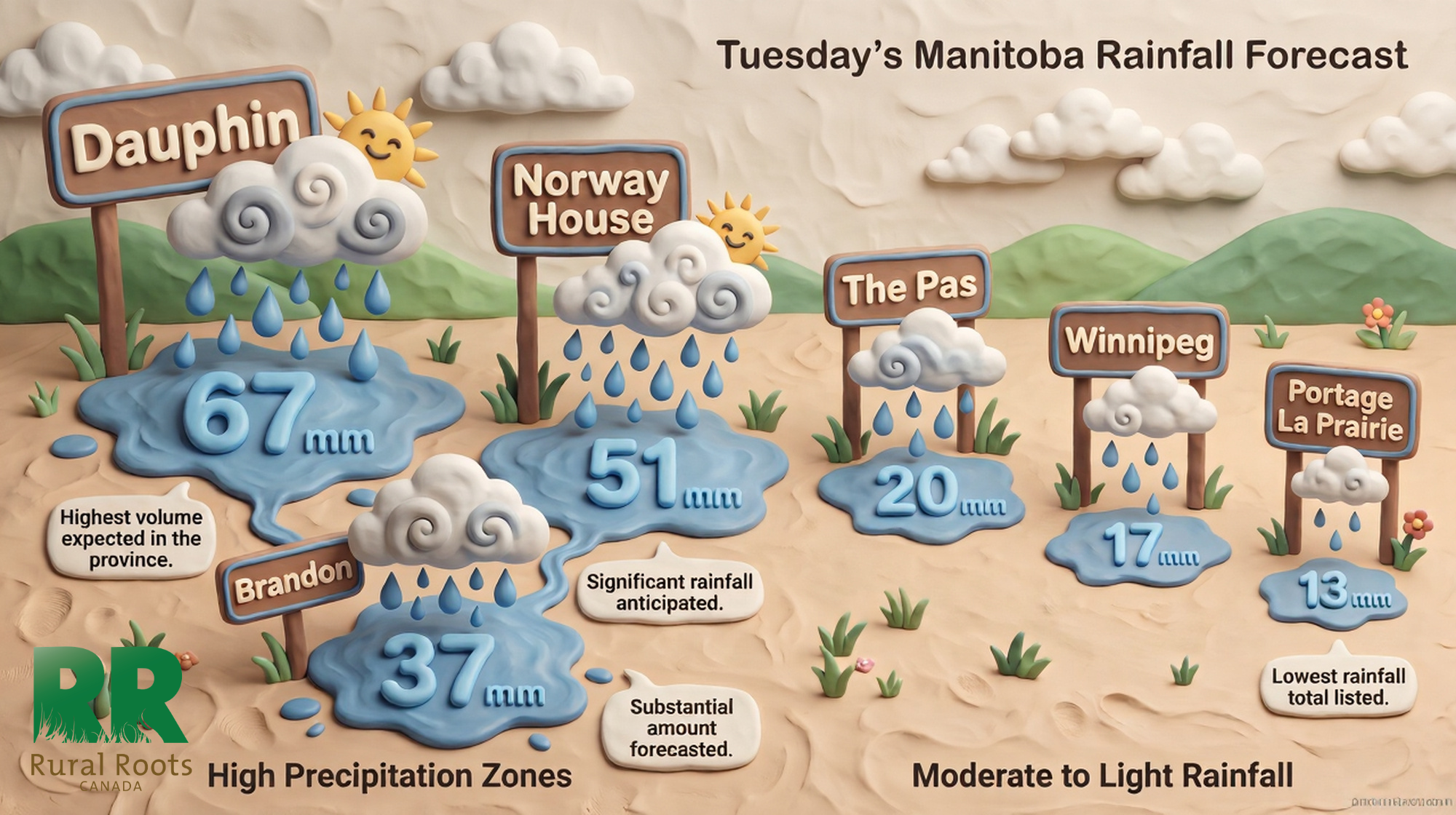
Tuesday
Peace Region
Showers or rain continue under cloudy skies with highs in the high teens or low 20s. The most organized precipitation is now shifting south and east as the blocking pattern weakens, so shower coverage in the Peace may become more scattered through the afternoon. That said, the region could still get 10 to 15 mm of rain Tuesday, and it is still not a productive field day. The trend, though, is moving in the right direction.
Alberta
Tuesday marks the beginning of Alberta’s recovery. The worst of the rainfall event is ending, and the province starts to dry out in the afternoon as the eastern blocking pattern weakens and the upper trough shifts southward. Some afternoon thunderstorm risk persists across central areas, but it is a fundamentally different day from Monday. Temperatures recover toward the high teens and low 20s across central and southern Alberta. Producers can begin assessing drainage and field conditions through Tuesday afternoon. Do not rush heavy equipment onto saturated soils. After what some areas have received in the past week, those soils need time.
Saskatchewan
One more showery day across much of the province before things improve Wednesday. Western Saskatchewan dries sooner, with central and eastern areas carrying the rain into Tuesday afternoon before clearing. Winds remain gusty through the morning. Tuesday is a transitional day, not workable, but by evening the trend toward improvement is clear. Afternoon highs will be in the low to mid-20s in southern Saskatchewan, and will reach the high 20s in the north as the spell of very warm weather continues.
Manitoba
Conditions moderate considerably after Monday’s severe setup, with scattered showers and decreasing winds. The province is still unsettled, but the worst of the active pattern is over. The surface low moves into central Manitoba, and heavier rain will continue there throughout the day. In the south, remnant instability keeps shower chances elevated through the afternoon. Temperatures in the high teens or low 20s with humidity values that still feel uncomfortable, though nothing approaching Monday’s extreme setup.

Canada Day
Peace Region
The Peace Region gets a break from the wet weather on Canada Day, and while there will be some cloud cover, significant rainfall is not expected. Because fields will be so wet, it may be best to just take the day off and join the festivities celebrating the country’s birthday. Highs will reach the low 20s and could potentially hit the mid 20s in areas where there is more sunshine.
Alberta
A genuine improvement arrives for most of Alberta on Canada Day. Sunshine mixes with cloud across central and southern regions. It will be cool in central regions with highs in the teens. In the southern and northern portions of the province, temperatures will reach the low-to-mid 20s. It is not a full field day yet. Soils in most areas are still carrying substantial moisture, but the direction is clearly positive. Alberta River Forecast Centre advisories will begin easing as river levels respond to the cessation of rainfall. Continue to follow those bulletins before working near any riparian areas.
Saskatchewan
Canada Day delivers across Saskatchewan. Sunshine returns to southern and central areas with temperatures climbing into the low 20s, and the turnaround from Sunday and Monday is dramatic. Southern Saskatchewan benefits from the fastest drying conditions. The northeast and east-central areas, which were wettest through the active pattern, will need more time, but Wednesday is the start of a real recovery window. That said, the heating that does occur from the sun’s return is likely to generate some afternoon showers and possibly thunderstorms. Their appearance will be random, so it’s not clear exactly where they will form. Severe storms are not expected. Scout your fields Wednesday rather than driving equipment onto wet soils. Know what you have before committing.
Manitoba
A mix of sun and cloud with temperatures returning to near-seasonal norms in the mid-20s makes for a much improved Canada Day compared to the chaos of the weekend. Western and central Manitoba should have a workable afternoon. Eastern Manitoba carries more residual cloud, but conditions are still considerably better than recent days. Canada Day will likely be rather muggy in southern Alberta, with relative humidity readings exceeding 90 percent in many areas. Dew points will be in the high teens.
Heat warnings may be required across southern Manitoba by mid to late week as heat and humidity continue to build, which, while uncomfortable, signals the return of growing conditions that crops have sorely missed through June’s cool, wet pattern.
Thursday
Peace Region
Showers continue under cloudy skies with highs in the 17 to 19 degree range. The Peace Region’s improvement continues to lag behind the rest of the prairies. Any dry hours Thursday should be used for field assessment and planning rather than equipment operations on soft ground.
Alberta
The drying trend continues across central and southern Alberta Thursday with a mix of sun and cloud and temperatures in the low-to-mid 20s. A weak disturbance passing through produces a good chance of afternoon and evening showers in the north, but the daytime picture is workable across most of the province. Lighter soils across the south and east are approaching usable conditions for spray operations. Heavier clay soils in central regions that absorbed 70 to 100mm over the past week may need several more days. Thursday is a legitimate scouting and planning day province-wide, and a spray day on lighter ground.
Saskatchewan
The second consecutive good day for most of the province, though periods of rain can be expected along the Yellowhead corridor, especially east of Saskatoon. Temperatures in the mid-to-upper 20s with mixed cloud, signalling a genuine return to summer weather. And while temperatures reach the 20s, dewpoints will be in the high teens. It will be humid in central Saskatchewan, with relative humidity values exceeding 90 percent. Herbicide applications that have been sitting since mid-June due to the persistently wet and windy pattern finally have a real window. Make those applications a priority. Canola and cereal crops that have been sitting in wet conditions need post-emergence attention, and this window is not guaranteed to last indefinitely.
Manitoba
The warming trend accelerates Thursday with temperatures pushing toward the mid-20s across southern areas, and humidity rising to match. Western and central Manitoba should be scouting fields and moving spray equipment on any fit ground. The heat building over southern Manitoba will feel like a dramatic change from the cool, wet week that preceded it. Crops that have been stunted by cool temperatures through June will begin responding to the warmth.
Friday
Peace Region
Intermittent showers continue with highs between 18 and 20. The Peace Region does not get a clean run into the weekend, but precipitation amounts will be minimal. Any dry window Friday should be captured aggressively.
Alberta
Friday continues Thursday’s improvement across central and southern Alberta with a mix of sun and cloud and temperatures in the high teens to low 20s. Scattered, isolated afternoon showers or non-severe thunderstorms can’t be ruled out, especially in the southern third of the province. Soil conditions on lighter ground will be fit for spray operations in most areas. A weak overnight shower chance for the north reflects another minor disturbance in the flow, but daytime conditions are workable. Use the Friday window hard before the weekend brings more variable conditions.
Saskatchewan
Friday is the warmest day of the period for the province, with temperatures pushing into the upper 20s across southern and central areas under a mix of sun and cloud. This is one of the best fieldwork days of the past month. Every warm day matters for crop development now. With temperatures having run below normal for much of June and late-seeded fields already at risk of early fall frost if July does not deliver adequate heat units, the warmth arriving this week is not just welcome; it is necessary. Prioritize getting post-emergence herbicide passes done.
Manitoba
Warm and pleasant Friday with temperatures in the mid-20s across southern areas under a mix of sun and cloud. The humidity, over 90 percent, will make it feel warmer and muggier. After the active June the province has endured, producers will take it. Central and western Manitoba should be in good shape for fieldwork. Eastern areas continue their recovery. This is the start of the best stretch of the summer so far for Manitoba agriculture.
Saturday and Sunday
Peace Region
The weekend in the Peace should be mainly dry, with a few scattered and isolated showers. The rain will be minimal, but will slow the drying process. There remains a lack of meaningful heat units. High temperatures will stay cool for early July – in the high teens. The Peace Region remains the outlier in an otherwise pleasant prairie-wide weekend. Producers there who still have seeding or spraying remaining are running out of calendar and should aggressively capture any break in the showers. The pattern shows no dramatic improvement early next week.
Alberta
In southern Alberta, it’s a dry weekend. Elsewhere, it is not a washout, but it is not completely dry either. A weak disturbance passing through overnight Saturday keeps shower chances elevated for northern and central areas Saturday night, with Sunday seeing a mix of sun and cloud and manageable conditions across most of the province. Daytime conditions should be workable across central and southern Alberta on both days.
After the extraordinary rainfall of June, wet and cool soils could influence the jet stream through the summer, potentially supporting continued unsettled conditions at times. But there is also the possibility of a pattern change driven by developing El Niño conditions that could bring warmer and drier weather. For now, the weekend looks reasonable for advancing field work across most Alberta regions. Temperatures in south central and southern Alberta should reach the mid to high twenties over the weekend, and in northern areas, highs in the low 20s can be expected.
Saskatchewan
For Saskatchewan, both Saturday and Sunday carry a mix of sun and cloud with temperatures in the mid-to-upper 20s across most of the province, continuing the improvement that began Wednesday. On Sunday, near the US border, highs near 30 are likely. With temperatures having run below normal through much of June, slowing crop growth, late-seeded fields are already at risk of early fall frost if growing conditions do not improve through July. The warmth arriving this weekend is critical for those fields. Use the weekend to push on herbicide applications, crop scouting, and any remaining field operations. The window appears to hold into early next week.
Manitoba
The warmest weekend of the summer so far arrives for Manitoba, with temperatures in the mid to high 20s across southern areas and a mix of sun and cloud both days. Rain is expected to sweep across southern Manitoba early Saturday morning. Once it departs in the afternoon, the remainder of the weekend will be dry. After enduring what is arguably the most active and dramatic June on the prairies in modern memory, producers in Manitoba get a genuinely summer-like weekend. Make the most of it.
EVENT FORECASTS
Ponoka Stampede, until July 1, Ponoka, AB
June 29 – Mostly cloudy, gusty wind to 40 km/h, chance of showers, high 21
June 30 – Partly cloudy, chance of sprinkles, light wind, high 21
July 1 – A mix of sun and cloud, chance of late afternoon showers, light wind, high 21
Portage Ex Fair, July 3-5, Portage La Prairie, MB
July 3 – Mostly cloudy, chance of showers, light wind, high 23
July 4 – Increasing cloud, chance of isolated showers, high 22
July 5 – Sunny, high 26
HAIL UPDATE
Damaging winds, rain, and hail impacts crops across the Prairies
The post Prairie Weather This Week – June 29 first appeared on Rural Roots Canada.