Prairie Weather This Week – June 8
This post was originally published on this site.


Prairie Weather (Rural Roots Canada) – More rain for most of the prairies until the weekend. Staying cool everywhere.
The active pattern that has defined the past two weeks on the prairies shows no sign of relenting. A series of systems will continue to move through the region, keeping showers and thunderstorm chances in the forecast through much of the week. The severe weather risk is real on multiple days, shifting from west to east with each passing system. Between rounds, warm and sometimes hot conditions return quickly as the broader pattern continues to draw subtropical moisture northward from the Gulf. For producers still trying to finish seeding or get herbicide passes done, workable windows exist, but they are short and require flexibility.

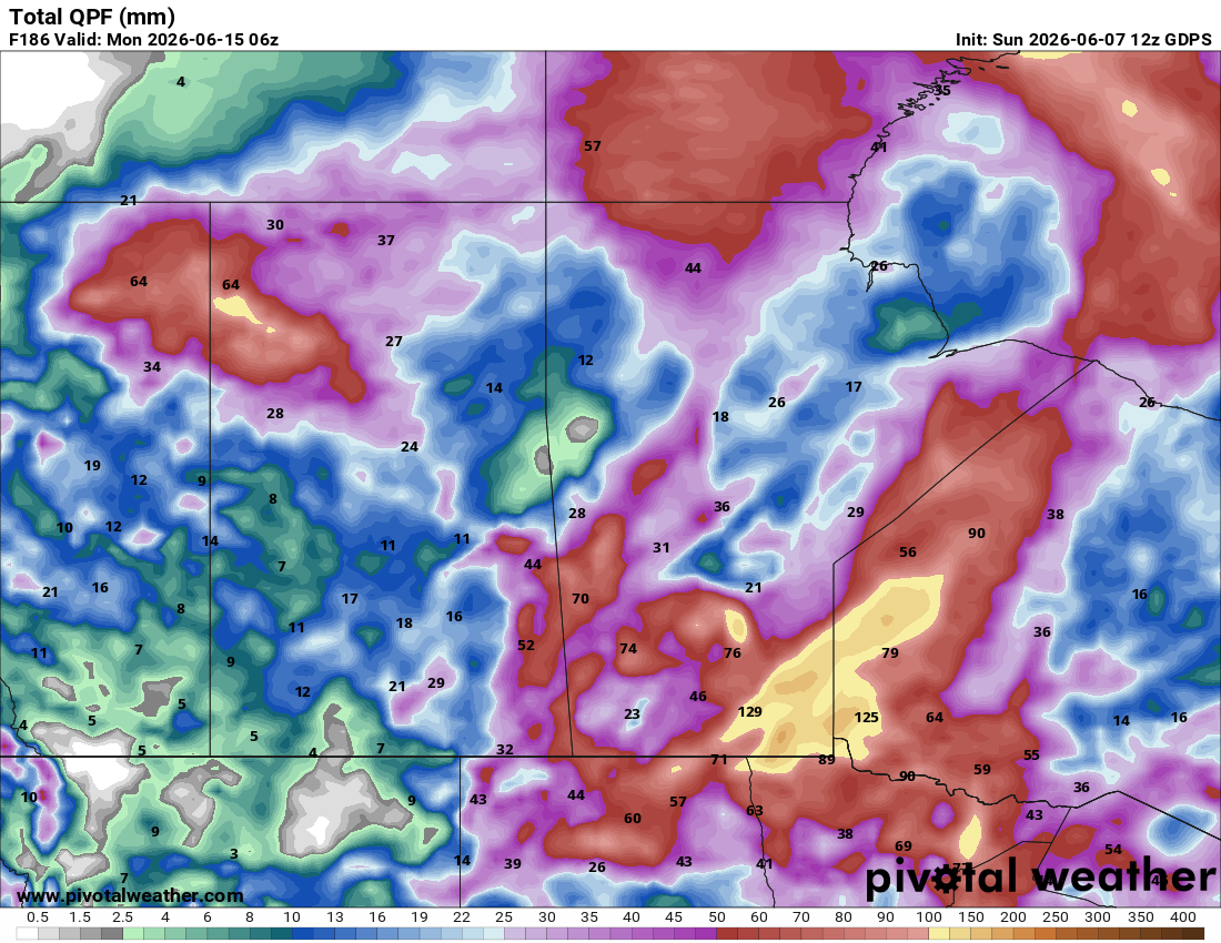
Outside of southern Alberta and southwestern Saskatchewan, there will be significant rainfall this week across the prairies. Southeastern Manitoba will be soaked, though most of the 100+ mm of rain will fall over the Canadian Shield, east of agricultural territory. The map below shows rainfall totals expected this week until midnight Sunday night:

Here’s a day-by-day breakdown:
Monday
Peace Region
A reset day following the weekend system. Expect a mainly sunny to partly cloudy sky throughout the day. Highs will return to near seasonal levels in the upper teens. Fields that absorbed rain over the weekend will need assessment before committing to heavy equipment. Tuesday looks cleaner for the Peace.
Alberta
The weekend system exits Monday, and a brief drying window opens, particularly across southern Alberta. The atmosphere becomes more stable, and the sky will clear from south to north through the day, with temperatures climbing back into the high teens to low 20s across central and southern areas. Northern Alberta holds onto cloud and shower chances longer as the system fully clears. The severe weather threat is done for now. Any producers in southern Alberta who saw minimal rainfall over the weekend should be evaluating field conditions Monday for a possible Tuesday seeding or spray window. The next system is not far behind, so the window is short.
Saskatchewan
Monday is a recovery day following the severe weather events in southeastern Saskatchewan over the weekend. Temperatures cool to the low-to-mid 20s on the backside of the system, with a mostly sunny sky across the province, except for the far north, where a swirling low will produce clouds and rain in the boreal forest. Central and northern Saskatchewan should see the best conditions Monday, with clearing skies by midday and highs near 22. Southern areas take longer to dry out and producers there should hold equipment until field conditions can be properly assessed.
Manitoba
Following the very active weather Sunday, Monday sees cooler temperatures in the low-to-mid 20s with increasing sunshine through the afternoon. A drier pattern develops briefly as cooler air punches in from the west behind the departing system. Western Manitoba recovers first, with central and eastern areas clearing through the afternoon. This is a day to assess crop and field damage from Sunday’s storms before planning the next field operations.
Tuesday
Peace Region
Improving conditions Tuesday with a mix of sun and cloud and highs climbing toward 20-21°C. The extended forecast for the Grande Prairie area shows a mix of sun and cloud through the mid-week period with highs returning to seasonal levels near 17-18°C. Tuesday is a workable day in the Peace. If fields are fit following the weekend rains, this is the window to move on seeding or spray passes.
Alberta
Tuesday delivers one of the cleaner days of the week for most of Alberta. However, cloud returns to southern and central areas. No significant precipitation is expected. Highs climb into the high teens or low 20s, and overnight lows settle into the single digits. Soil moisture from the recent rounds of heavy rain means germination conditions for crops already in the ground are good across the province. Tuesday is the day to get herbicide equipment moving if fields are passable. The next system arrives by the weekend, so mid-week represents the core of the workable window.
Saskatchewan
The warm, humid air mass returns quickly ahead of the next system building to the west. Highs climb back into the low to mid 20s across southern and central Saskatchewan on Tuesday, and the instability begins to build again. A severe weather watch cannot be ruled out for portions of the province Tuesday afternoon and evening as the next round of convection develops. Check for weather watches and warnings through the afternoon. The morning hours are your best window for field operations Tuesday across southern Saskatchewan. And, to be clear, the chance of afternoon storms isn’t all that great. But it’s also not zero.
Manitoba
Hot and humid conditions return to Manitoba Tuesday, with highs potentially reaching the low 30s across southern areas. Temperatures warm back up quickly, with the potential for another round of severe weather particularly east of the Red River Valley. Southern Manitoba should be weather-aware Tuesday afternoon and evening. The Saskatchewan-Manitoba border region is again flagged as a focus area for organized storm development, but those storms will travel east throughout the day, and all areas south of the lakes will be affected.
Wednesday
Peace Region
Wednesday’s a cloudy day for the Peace with highs in the mid to upper teens. Showers are likely, but they will be scattered and isolated, with accumulations under 5 mm. There may be chances for field work in between the rain showers. The wind will be light to moderate from the west….something to monitor for those who play herbicide spraying.
Alberta
For central and southern Alberta, it will be cloudy and cool with scattered showers. Highs will only reach the mid teens. Severe weather is unlikely. A disturbance tracking through northern Alberta will track scattered showers across the province from north to south. It’s impossible to predict exactly where the showers will develop, but it is safe to say some farms will be rained upon, and others won’t. Overnight lows will generally fall into the upper single digits and low teens. Producers who have not been able to complete herbicide passes or finish remaining seeding should be pushing hard if they can Wednesday. The next significant system is building and expected to arrive around the weekend.
Saskatchewan
Wednesday is a complicated day. The next system drives another round of showers and thunderstorms across eastern Saskatchewan and southern Manitoba. Severe weather and heavy rain are both possible, with the corridor from eastern Saskatchewan to central Manitoba the primary area of interest. Western and central Saskatchewan fare better Wednesday, with partly cloudy skies and highs in the mid-20s. Saskatoon and Regina have largely missed out on the significant precipitation events of the past several weeks and continue to be in position to miss the next round as well. Producers in those areas should be making the most of Wednesday’s conditions for field operations.
Manitoba
Wednesday brings another round of showers and possible thunderstorms to much of the province as the system works through. Severe weather cannot be ruled out, particularly across southern Manitoba where the setup mirrors Tuesday’s. Heavy rain is possible in corridors where storm training develops. “Training” is characterized by a series of storms, each following the storm ahead, as if on a railroad track. One storm after another. A cooler, windier period develops on the back side of the system, bringing a noticeable temperature drop by Thursday morning. Manitoba producers should plan for very limited field activity Wednesday.
Thursday
Peace Region
Another cloudy day for the Peace with a mix of sun and cloud and highs near 18. From time to time, throughout the day, expect some rain showers. Again, the rain will be light, and accumulations will be, at most, in the 3 to 5 mm range.
Alberta
The back side of the Wednesday system brings cooler, breezy conditions to Alberta Thursday. Highs drop to the mid-to-upper teens across most of the province, with a chance of showers across northern and central areas and northwest winds gusting to 40-50 km/h in some locations. Southern Alberta holds on to partly cloudy skies and manageable conditions. The wind is the primary concern Thursday, especially in central Alberta, east of Red Deer and Edmonton. Spray operations will be largely halted across the province given the blustery conditions, and dust risk in any areas that remain dry is elevated.
Saskatchewan
Thursday begins the reset ahead of what could be the most promising moisture event of the extended period. The upper low moving eastward through Saskatchewan will bring an end to the somewhat warmer conditions that have dominated much of the region, with daytime highs generally cooling back into the upper teens. Showers are possible across southern and eastern areas Thursday as the system pushes through. The western half of the province dries out and temperatures moderate. Overnight lows drop to the low double digits. A brisk wind will also create concerns in southern Saskatchewan Thursday, potentially kicking up dust on dry fields, and affecting herbicide spraying.
Manitoba
Cooler and breezy Thursday following the Wednesday system, with highs in the high teens and a chance of lingering showers through the day. The respite from heat is real, and it continues. Thursday gives producers a chance to reassess field conditions before the next warm-up arrives over the weekend.
Friday
Peace Region
Increasing cloud Friday with shower chances developing as the next system approaches from the Pacific. Highs will be in the 17 to 19 degree range. It should be noted the Pacific system weakens rapidly as it cross northern British Columbia, and by the time it reaches the Peace, showers will be minimal and scattered, with very little accumulation. Behind the Pacific system, high pressure builds rapidly and sunshine returns for the next few days.
Alberta
Friday is an unsettled day across Alberta, with chances for non severe thundershowers from the Peace region, though Edmonton to Lloydminster. Scattered, lighter showers are possible south of the Trans Canada Highway. There will be plenty of sunshine across the province, though, with isolated clouds and showers popping up due to instability. Highs will only reach the mid teens.
Saskatchewan
Wind will be a major feature of Friday’s weather in southern and central Saskatchewan. It may be a difficult day for field work, due to the wind, showers, and possible non-severe thunderstorms. Central Saskatchewan, which has been running a significant moisture deficit despite the active pattern around it, also has a chance at some rainfall, though it may not be meaningful. Along and just south of the Yellowhead highway is where the heaviest accumulation of rain (5-7 mm) is expected. Afternoon temperatures will be cooler than average, peaking in the mid teens.
Manitoba
Wet weather is again expected Friday across both northern and southern of Manitoba, including the agricultural south. Plan to stay inside while the rain falls outside. The region will be under a weak trough, emanating from a low in northern Ontario. The map below shows precipitation expected in southern Manitoba between midnight Friday morning and midnight Saturday morning:

It will be cool, with highs reaching the mid teens at best. The sun will manage to make a few peek-a-boo appearances during the day.
Saturday and Sunday
Peace Region, Alberta, Saskatchewan, and Manitoba
Two areas of high pressure – one over the Rockies, and the other in northern Montana, will keep the sky clear and sunny through the weekend across Western Canada. All weekend long, Clouds will be hard to find between Vancouver Island and Winnipeg, The only precipitation worth noting will be some afternoon showers and thunderstorms in southern Manitoba. The other two provinces remain dry. Across all three provinces, Saturday’s high temperatures are expected to come close to 20 degrees. On Sunday, it will be warmer, with temperatures reaching the mid 20s in Alberta and Saskatchewan, and the low 20s in southern Manitoba. Should this materialize, this summer-like pattern should be good for farmers.
EVENT FORECASTS
Cypress Farm and Ranch Show, June 11 and 12, Medicine Hat, AB
June 11 – Mainly sunny, breezy, high 19
June 12 – A mix of sun and cloud, gusty wind to 50 km/h, high 17
Innovations in the Field, June 10, Coaldale, AB
June 10 – Mostly cloudy, chance of showers,, high 17
Biggar Country Music Festival, June 13, Biggar, SK
June 13 – Sunny, high 22
COMPARE: Prairie Weather This Week – Midweek Update June 4
The post Prairie Weather This Week – June 8 first appeared on Rural Roots Canada.