Prairie Weather This Week – Midweek Update Apr 2


Prairie Weather (Rural Roots Canada) – Spring snow on the western prairies replenishes soil moisture
A Montana low brings a potent spring snowstorm to the prairies Thursday, then a brief but welcome window of warmth and quiet arrives for the weekend.
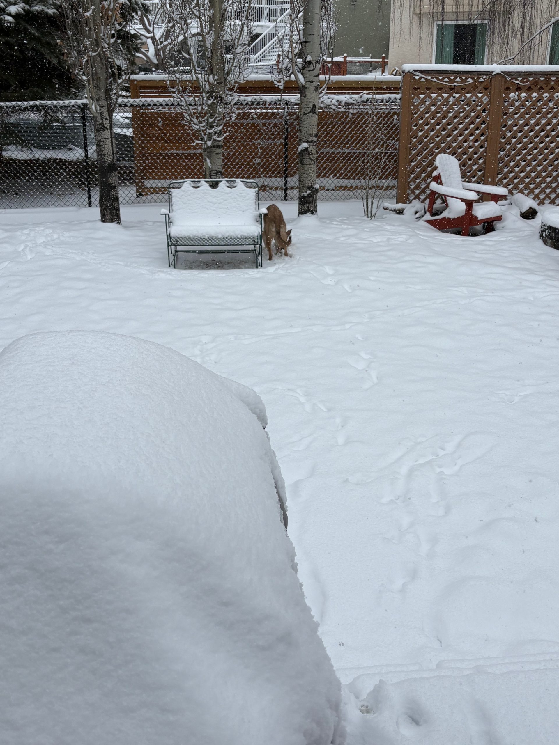
The dominant feature Thursday is an inverted trough extending northward from a surface low centered over central Montana. This trough is drawing a broad southeasterly flow across all three Prairie Provinces, transporting sufficient moisture to fuel a widespread precipitation event from Alberta to southwestern Saskatchewan. For Alberta, the heaviest snow is falling in my Calgary back yard:

And, as the map below shows, Calgary is the bullseye for the heaviest snow, with some not-insignificant totals elsewhere in Alberta. The map shows expected accumulation until Sunday evening, with most of the snow falling today (Thursday Apr 2):

For the farmlands of Saskatchewan and Manitoba, it’s a very different picture, with little snow accumulation expected over the same period of time:

Thursday
Alberta
An active and disruptive day for much of Alberta. The inverted trough tracking northward from Montana is producing a swath of precipitation across the province, with the heaviest snow focused on Calgary and surrounding regions. Because of convection, there may be higher snowfall totals in localized areas. North of Red Deer, expect about 2 to 4 cm. Across southern Alberta, snowfall rates will taper off through the afternoon. Up to 15 cm is possible along Highway 1 west of Medicine Hat. Blowing snow will reduce visibility on rural roads and in open fields. The precipitation could linger through the night in southeastern Alberta, tapering off by Friday morning. Through it all, it’s relatively warm That promotes the creation of heavy, wet snow. it may also lead to some afternoon melting as temperatures throughout the province climb slightly above 0. Melting would be much faster with sunshine, but that is unlikely in Alberta Thursday. Producers with early calving operations should closely monitor newborns through the day and overnight. Wet, heavy snow combined with cool temperatures creates challenging conditions for young animals, and the moisture may cause temporary access problems on field approaches and rural roads.
Saskatchewan
The inverted trough reaches southwestern Saskatchewan today, bringing generally 2 to 4 cm of snowfall to most areas. An exception is the Cypress Hills, where an upslope flow could push totals to 10 cm or more. Temperatures near or possibly above 0 by Thursday afternoon may moderate the heaviest accumulations. Use caution on rural roads, particularly on bridges and shaded highway sections. Significant snow is not expected in the rest of southern and central Saskatchewan. Temperatures will rise above the melting point across most of the province in the afternoon.
Manitoba
The low in the northern US providing snow to the western prairies is expected to track southward, pulling southeast Manitoba largely out of the precipitation zone. The southeast corner of the province may see only a few brief wet flurries this afternoon. . The remainder of Manitoba should stay mainly dry through the day. From the US border all the way north to Thompson, highs will range from -3 to +2.
Good Friday
Alberta
Before sunrise, a secondary low is forecast to develop along the northern extent of the inverted trough over north-central Alberta and track east into Saskatchewan during the day. This will bring a few additional centimetres of snow along its path through central portions of the province. Behind it, as the precipitation pulls out, the sky begins to clear through the afternoon over southern and central Alberta. Snowfall wraps up across eastern Alberta by late morning or midday. It will be significantly warmer in southern and central Alberta, with double digit highs possible south of the Yellowhead highway. There is not a lot of snow cover in that area, and what there is will melt rapidly Friday, hopefully recharging soil moisture levels. North of the Yellowhead, it will be a typical spring day, with highs close to 5.
Saskatchewan
The low tracking eastward from Alberta will spread snow across northwestern parts of the province through the day. Expect partly to mostly cloudy skies province-wide, with the chance of occasional flurries in southwestern Saskatchewan. Daytime highs will largely depend on cloud cover, generally hovering near the freezing mark under heavier clouds, but climbing toward 5°C in sunnier areas, particularly in the south.
Manitoba
Manitoba remains on the periphery of the storm track Friday. A few flurries are possible in the southwest, but unlikely. Most of the province should see a mainly cloudy to partly cloudy sky with no accumulating snow. There won’t be any significant barriers to travel. Similar to Saskatchewan, high temperatures across the province will range from about +2 to -4 across the entire province.
Saturday
Alberta
An upper level ridge and a favourable wind at the surface will combine for a warm day Saturday across southern and central Alberta. The warm-up will be meaningful, with daytime highs rising into the 7 to 11 degree range across most regions. Southern Alberta will see the warmest conditions, and the ground may become dry enough to provide a good window for early fieldwork, fence checks, and monitoring calving operations in more comfortable conditions. The wind, though will be significant from Calgary to Drumheller to Coronation. To the north, up to 10 cm of snow could fall Saturday in and north of Cold Lake. This includes most of the boreal forest south of the 59th parallel.
Saskatchewan
High pressure attempts to build into the region, but Saskatchewan finds itself in a transition zone between the departing low to the east and the approaching ridge to the west. As the tempeerature map for the late afternoon snows, the building ridge wins the battle.:

Expect a partly cloudy sky with a continued chance of occasional flurries in the north. Those flurries are likely to stay within forested areas, and accumulations will be minor, likely less than 5 cm.
Manitoba
As the map above shows, temperatures in Manitoba will rise above the melting point, except for the far north. Similar to Saskatchewan, a mix of high pressure to the north and an active storm track to the south keeps conditions somewhat unsettled and uncertain. The storm track is likely to remain south of the border, and partly cloudy skies are the most likely outcome for Manitoba, with the southwest carrying the greatest chance of cloud and flurries. That’s only if the storm track moves farther north than expected. At best, temperatures are expected to reach around 5 degrees, which is near to slightly below seasonal for early April.
Easter Sunday
Alberta
Sunday continues the mild and settled theme, but a bit cooler, with sunshine and highs again in the 3 to 8 degree range across most of the province. Flurries are likely over the foothills west of Calgary, but otherwise it will be dry. A good day to take advantage of any fieldwork opportunities before the next system arrives early next week. Enjoy it, as this stretch of warmth is expected to be brief.
Saskatchewan
Conditions change slightly compared to Saturday as the upper ridge edges a little farther east. Expect a mix of sun and cloud, with sunnier weather in central and northern areas. Southern Saskatchewan will remain closer to the storm track in the northern US, keeping cloud cover more persistent there. Highs should again reach near 5 degrees across the south, with slightly cooler readings to the north.
Manitoba
Northern areas of Manitoba should benefit from increasing sunshine Sunday as high pressure gains more influence. Southern regions, particularly along and south of the Trans-Canada Highway, will see more cloud with lingering flurry chances. Temperatures hold in the 1 to 3 degree range in the south, with cooler readings across central and northern regions. Light snow is possible in parts of central Manitoba Sunday, as shown on the map below:

Early Next Week
Attention turns to the potential development of a low-pressure system over northern Alberta early next week. If this system evolves as currently expected, it could draw milder air into the southern Prairies by Tuesday and Wednesday, potentially pushing daytime highs into the mid-teens in Alberta and toward 10 in Saskatchewan and Manitoba. However, current guidance also indicates the potential for another round of accumulating snowfall by midweek, likely in the Wednesday-to-Thursday timeframe, particularly in northern and central areas. Track, intensity, and precipitation type all remain uncertain.
ALSO READ:
Not weather related, but a great story here: Century old farm faces uncertain future
The post Prairie Weather This Week – Midweek Update Apr 2 first appeared on Rural Roots Canada.