
Prairie Weather This Week – Midweek Update Aug 6
This post was originally published on this site.


Prairie Weather (Rural Roots Canada) – More relief from the heat, but where is the rain?
A large Hudson Bay low continues to dominate the pattern this week, and it continues spinning in place through the weekend and into next week. With that low going nowhere, the prairies are kept in a cooler northwesterly flow. Temperatures run close to or slightly below seasonal values through the weekend, with daytime highs generally in the low-to-mid 20s and overnight lows dipping into lower double digits. The exception is southern Alberta, where stress continues to build in crops that have gone without meaningful rain, and where widespread relief may not arrive until Sunday.
For Thursday, as the map below shows, parts of Saskatchewan and Manitoba have a chance at wind and rain, and thunderstorms cannot be ruled out.

Going into the weekend….
Thursday

Peace Region
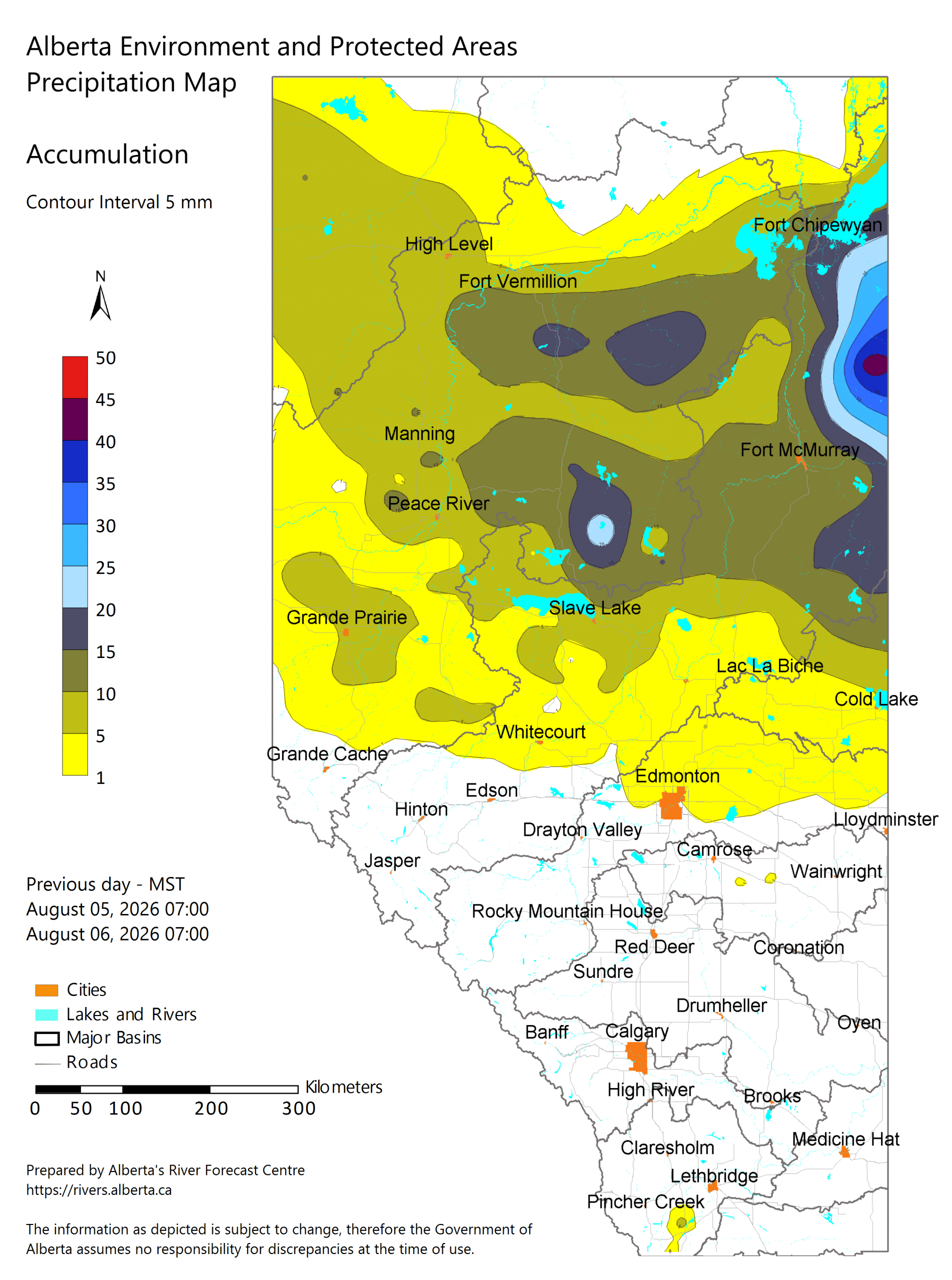
A quieter day follows an active night, with a cold front that brought steady showers to parts of the Peace Region overnight. To the east, there were thunderstorms and a surprise gust above 90 km/h near Slave Lake. Overnight rainfall came in at around 5 to 10 mm throughout northwest Alberta, with radar-inferred totals closer to 20 mm in spots. Thursday should be calmer, though wildfire smoke drifting in from BC and the northwestern US may intermittently affect the region over the next few days. Afternoon highs can be expected to reach 18 or 19 degrees.
Alberta
As the map above shows, there has been considerable rainfall in northern Alberta between 7:00 Wednesday morning and 7:00 Thursday morning. The cold front stretched across central Alberta continues to weaken as the supporting low pulls eastward. Expect a less active day than last night, with wind gusts staying below 70 km/h and thunderstorm activity fairly limited due to a lack of instability. Smoke moving into southwestern Alberta could get pushed back somewhat by east winds this evening, but plan for hazy skies to linger off and on through the next few days. If your area caught the overnight rain, this is a good day to check for any wind damage from those stronger gusts before getting back into the field. South of Highway 16, it was a dry night, and dry weather will continue during the day. Highs will range from the high teens in central and northern Alberta to the low 20s in southern Alberta.
Saskatchewan
A stronger upper impulse than yesterday’s tracks toward Manitoba Thursday, bringing locally heavy rain along its path over the northern grain belt of Saskatchewan, with 20 to 30 mm possible before the system pushes into central Manitoba. East-central Saskatchewan could also see wind gusts up to 80 km/h Thursday afternoon, separate from any thunderstorm activity. The sky should remain sunny through most of central and southern Saskatchewan, though clouds will pass through from time to time. Highs across most of the province will reach the high teens, possibly the low 20s in the south.
Manitoba
Thursday is the day to watch. Higher instability and stronger shear than yesterday bring a risk of severe thunderstorms to much of southern and central Manitoba in the afternoon, with 2 to 4 cm hail and wind gusts of 90 to 100 km/h the primary threats (see map at the top of this page). Locally heavy rain is possible as the system tracks in from Saskatchewan, with totals of 20 to 30 mm in spots. If you’re in the path, secure equipment and be ready to move livestock away from exposed areas before the afternoon storms develop. Highs across southern Manitoba will reach the low 20s.
Friday
Peace Region
Skies alternate between sun and cloud, with some rather cool weather, as highs remain in the high teens. An isolated shower can’t be ruled out as another weak disturbance rides over the ridge from BC. The areas that do get the isolated showers can expect accumulations of only 3-5 mm. The rain is not significant, but could be an annoyance to anyone caught by surprise while doing fieldwork.
Alberta
A mix of sun and cloud continues through central and northern regions, with scattered afternoon or evening showers and thunderstorms possible as another weak system crests the BC ridge. The showers are more likely in the Peace Region, the northern foothills and Wood Buffalo, in northeastern Alberta. Southern Alberta should be the warmest part of the province, generally in the 24 to 28 degree range, with 30 degrees possible in the Lethbridge/Milk River regions. Central areas will hold in the low-to-mid 20s. Coverage stays fairly spotty, so don’t be surprised if your neighbour gets a downpour while you stay dry, or the reverse.
Saskatchewan
Hit-or-miss showers continue in northern Saskatchewan. In the south, dry conditions persist, and there will be more sun than cloud. It will be a good day for fieldwork in most of Saskatchewan’s agricultural territory. Overnight lows in the 10 to 14°C range make for comfortable sleeping weather. In the daytime, highs will reach the mid-20s. In northern Saskatchewan, with the rain, highs will only reach the mid-teens.
Manitoba
A calmer day follows Thursday’s severe risk, though scattered shower and thunderstorm chances remain in play as further disturbances move through central and northern regions. The map below shows 24-hour precipitation for Friday:

The southwest is likely to stay dry. Temperatures stay comfortable, generally in the low-to-mid 20s.
Saturday
Peace Region
A mix of sun and cloud holds, with a modest chance of a passing shower in the early morning and cool, comfortable temperatures continuing to dominate. With haying underway across much of the region, watch the cloud breaks closely. A shower that dumps even a few millimetres on cut hay can set drying back a day or more, so it’s worth timing your cutting and raking around the driest stretches of the afternoon rather than committing a large acreage all at once. Expect highs near or slightly above 20 degrees.
Alberta
The pattern holds steady, with periods of cloud and scattered shower or storm chances continuing to favour central and northern areas more than the south. The map below shows expected rainfall during the day:

With highs in the mid to high 20s, southern Alberta remains the warmest part of the province, though still shy of the heat seen earlier in the summer. This is generally solid haying weather for the south, with lower humidity and a better shot at a full drying window than areas further north.
Saskatchewan
Showers stay hit-or-miss across northern Saskatchewan, with the southwest still waiting on any meaningful moisture. That dry stretch has been tough on pastures and pulse crops, but it’s been favourable for hay curing, so producers there have likely had an easier time getting a clean, dry bale than those further north or east. If you’re managing crops in that corner of the province, today likely offers little relief on the moisture front, though tomorrow looks more promising. Across the south, highs will reach the mid to high 20s. North of the Yellowhead Highway, highs will only reach the high teens or low 20s.
Manitoba
As the Hudson Bay low continues to spin, rain will be dragged into northern and central Manitoba again on Saturday, while the south remains dry under a mix of sun and cloud. Meaningful moisture is not expected in Manitoba’s agricultural regions. It will be seasonably cool, as highs across the province peak in the high teens or low 20s at best.
Sunday
Peace Region
Conditions stay unsettled, with periods of cloud and a continued chance of showers as the week’s pattern persists. The animated map below shows the rainfall pattern expected in the Peace Region, the rest of Alberta, and BC on Sunday:

With the showery weather, the Peace can expect widespread rain of about 10 mm, with some localized accumulations nearing 30 mm. Temperatures will be held to the mid-teens
Alberta
This looks like the day the central and southern regions catch a break, with widespread showers expected to reach that part of the province after more than a week of heat and dryness. It won’t undo the moisture deficit that’s built up, but it should offer at least some relief for stressed crops and pastures. The animated map above shows Sunday’s expected rainfall, and it looks like most regions except the northeast will get at least some moisture. Highs in northern and central regions will reach the mid-teens. In the farthest reaches of southern Alberta, it could warm up to the mid to high 20s.
Saskatchewan
The same system bringing rain to southwestern Alberta reaches into southwestern Saskatchewan today, the first widespread shower activity that part of the province has seen in over a week. Elsewhere, scattered shower and storm chances continue in the more typical hit-or-miss fashion. If you’ve got hay down anywhere in the path of this system, today is the day to get it baled early or accept that it may need extra drying time once the rain clears. Along the US border, highs will climb to the high 20s. For the rest of the province, though, it will be considerably cooler, with afternoon temperatures in the high teens or low 20s.
Manitoba
Light showers and storms remain possible as the broader pattern continues, with temperatures holding in the comfortable low 20s. Significant rain is unlikely in agricultural areas. By contrast, the rain will be heavy in northeastern Manitoba, all the way to the Hudson Bay coast.
Looking Ahead
Forecast guidance points to the Hudson Bay low finally shifting farther east by the middle of next week, allowing the ridge over BC to expand across the Prairies and temperatures to rebound. If that transition plays out as expected, many locations could see afternoon highs climb back into the upper 20s and low 30s by the end of next week, with some southern Saskatchewan and Manitoba communities potentially approaching or exceeding 30°C again.
EVENT FORECAST:
Dawson Creek Exhibition and Stampede, until August 9, Dawson Creek, BC.
August 6 – Sunny, high 20
August 7 – A mix of sun and cloud, evening showers, high 21
August 8 – Partly cloudy, chance of showers, high 20
August 9 – Mostly cloudy, chance of showers, high 19
ALSO: More on the Dawson Creek Exhibition and Stampede
The post Prairie Weather This Week – Midweek Update Aug 6 first appeared on Rural Roots Canada.