
Prairie Weather This Week – Midweek Update August 13
This post was originally published on this site.


Prairie Weather (Rural Roots Canada) – Rainy, cool weather ends the week across the southern Prairies

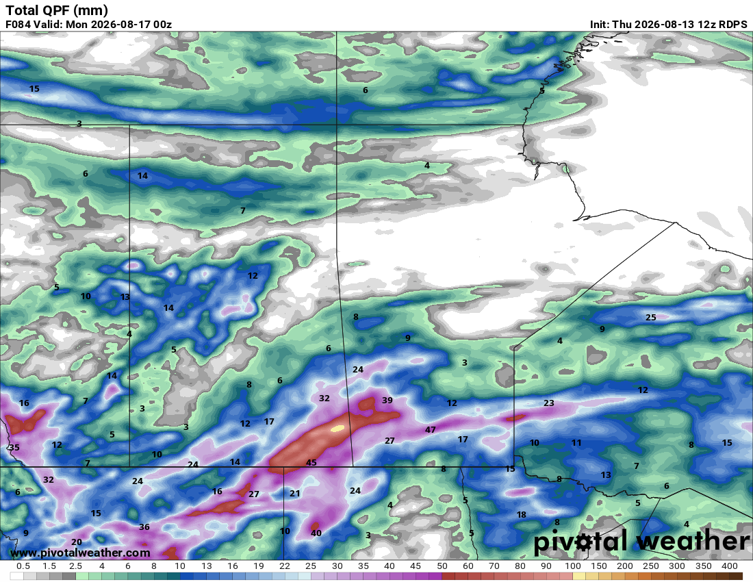
There’s little sign of a significant warm-up through this stretch, and the next notable opportunity for more widespread rain looks to be Tuesday and Wednesday of next week as another weak trough moves through. That’s not typical August weather, but for a region with such a stark moisture divide right now, cool and periodically wet may be exactly what’s needed in the south, even as producers in the north continue hoping for a break to finish haying and catch up on fieldwork. The map below shows expected rainfall accumulation up to Sunday evening:

The best chance for rain this week comes Thursday and Friday across southern and central Alberta and southern Saskatchewan, pushing east into southern Manitoba late Friday into Saturday. Whether that rain helps or hurts depends heavily on where you farm and what stage your crop is at. Southern Alberta and Saskatchewan need it badly after a dry stretch, while parts of northern Alberta are already dealing with too much moisture and could do without more.
Thursday
The map below shows the thunderstorm threat for Thursday on the prairies, and anything that develops will affect northern Alberta and parts of Saskatchewan:

The above map only shows where there is a chance for thunderstorms. It does not show all areas at risk for rain Thursday.
The map below shows where it is likely to be raining in the late afternoon, and parts of the foothills southwest of Calgary could see significant accumulation. Lesser amounts are expected in fields over flatter terrain:

Southern Alberta has largely missed out on the rain that has affected much of the rest of the prairies, so for many this is welcome moisture. For others who have begun harvesting, the timing may not be so great. There are concerns over the effect the rain may have on the quality of lentils.
Peace Region
Conditions stay quiet, with wildfire smoke not expected to be an issue today as the upper flow shifts it south of the border. Given how wet the Peace has already been this season, a calm day is a welcome chance to keep working through hay and field operations. That said, a few isolated afternoon showers can’t be ruled out north of Alberta Highway 2 and BC Highway 97. It will be rather cool for mid-August, with highs in the mid-teens.
Alberta
The big story Thursday is persistent rain in the southern foothills. From Longview to Waterton, upslope flow could bring 50 to 80 mm of rain by Friday morning, with local amounts potentially higher. This is exactly the kind of rain southern Alberta has been waiting for. The province’s latest crop report shows a widening moisture divide: 58.1% of crops rate good-to-excellent province-wide, but that’s down from 60.3% a week earlier as the South and Central regions continue drying out, while the North East, North West, and Peace are dealing with the opposite problem, excess moisture restricting field access and slowing haying. Sub-surface moisture sits at 89% good-to-excellent in the Peace, 86% in the North West, and 71% in the North East, a sharp contrast to the drying south. Temperatures across Alberta Thursday will be below average, with highs only in the mid-teens.
Saskatchewan
The earlier threat of severe thunderstorms in southwestern Saskatchewan now looks negligible, as persistent cloud and showers through the morning have kept the atmosphere capped. Farther north, scattered showers remain possible across the eastern and northeastern parts of the province. Harvest is underway in the southwest, with pulse crops now coming off alongside the winter cereals and fall rye that led the way earlier in August. And while the threat of thunderstorms may have lessened in southwestern Saskatchewan, significant rainfall is expected to develop in the late afternoon. If you’re combining peas or lentils, today’s cloud and lingering shower activity may slow things down, but for many it’s a small price for the moisture reaching a region that needs it. The rain in the southwest will keep the region’s high temperatures in the teens, while it will warm to the low 20s elsewhere in the province.
Manitoba
Scattered showers are possible across the Interlake and southern Manitoba Thursday, though the bulk of this week’s rain is still working its way east from Alberta and Saskatchewan. Harvest has begun for winter cereals and some early-planted barley and peas, and hay quality remains good with average to above-average yields on the first and second cuts. Dugouts sit at 70%, but pastures could still use rain, so if any of this week’s moisture reaches grazing land, it’ll be put to good use. Again, overall, today will be dry in most regions, with highs across the province reaching the low 20s, with a mainly sunny sky.
Friday
Peace Region
Quiet, cool conditions continue, holding in the upper teens, with bright sunshine for most of the day. There is no chance of any meaningful precipitation or storms.
Alberta
Outside of the Peace Region, this is expected to be one of the better chances for rain this week, with a disturbance bringing increased cloud and scattered showers to southern and central Alberta. Rainfall totals will vary considerably over short distances, so don’t be surprised if your neighbour gets considerably more or less than you do. This map shows expected rainfall in Alberta on Friday. The highest amounts are right near Calgary, up to 30 mm:

Northern Alberta should see less widespread precipitation today, though isolated showers remain possible. For producers in the south watching soil moisture drop, this is a meaningful, if not complete, step toward recovery.
Saskatchewan
Showers develop across southern Saskatchewan today as the same disturbance affecting Alberta pushes east. Central and northern Saskatchewan see more of a mix of sun and cloud, with scattered showers possible as individual disturbances move through. Harvest activity in the southwest, including the pulse crops now coming off, will likely see some interruption today, but the moisture is a net positive given how dry that region has been. The heaviest rain is likely in the southeast, in a line from the Saskatchewan-Montana-North Dakota border northeast to Whitewood and Moosomin. Across the province, temperatures will be suppressed, reaching only the high teens.
Manitoba
Cloud increases through the day as the disturbance responsible for Alberta and Saskatchewan’s rain begins reaching toward the province, with shower activity expected to develop later today and into Saturday. The showers will likely concentrate on Western Manitoba Saturday, but cloud will spread across the south. In western regions, with the wet weather, highs remain in the teens, but elsewhere in Manitoba, expect highs in the 22 to 24 degree range. Given how much of the province’s harvest and haying is already underway, this rain is a mixed blessing: helpful for crops still filling, less convenient for anything cut or desiccated and waiting to come off. Spring cereals continue advancing through the soft-to-hard dough stage, with desiccation starting in some fields and oat swathing expected to begin this week, so keep an eye on the forecast if you’re timing pre-harvest applications around this system.
Saturday
Peace Region
Saturday is a very uneventful weather day across the Peace Region, with sunshine through the day. Conditions stay settled and cool, with highs in the low 20s and next-to-no chance of any significant precipitation.
Alberta
Behind Thursday and Friday’s rain, conditions should turn somewhat quieter, with high pressure building in at the surface. The overall cool, unsettled pattern doesn’t change significantly. Expect highs in the 19 to 22 degree range. With cool air remaining aloft, afternoon heating can still trigger scattered showers and possibly a few thunderstorms, and a stronger cell could produce locally heavy rain and gusty winds. Widespread severe weather isn’t expected.
Saskatchewan
Showers continue to spread eastward into the province today as the disturbance that brought Thursday and Friday’s rain to the southwest moves through. Rainfall will be hit-and-miss, so some fields will see a meaningful boost while others largely miss out. Late in the day, the showers will move out, and the sky will clear. Highs will climb to 19 to 21 degrees.
Manitoba
This is the day the week’s system reaches Manitoba most directly, with increasing cloud and shower activity as the disturbance arrives. It will be a rainy day across southern Manitoba and the Interlake, and some of the rain may fall heavily, particularly in southwestern Manitoba. The system moves through quickly, and should be well on its way into Ontario by the evening. Accumulations of 30 to 40 mm are possible north of the Trans Canada Highway. High temperatures of 17 to 20 degrees are likely across the southern half of the province.
Sunday
Peace Region
Little change is expected, though it will warm up a bit. Expect highs in the low 20s with bright sunshine for Sunday, as high pressure holds on. There are no major new systems in the immediate forecast.
Alberta
Showers will move through central Alberta during the day, with a chance of a thunderstorm developing along the foothills by afternoon. High temperatures will climb to the 22 to 25 degree range across the province, and most areas will see at least some sunshine.
Saskatchewan
No specific threats stand out today, with conditions generally calmer as the week’s system clears the province. While the day will be mainly sunny, a few scattered afternoon showers can’t be ruled out in southern Saskatchewan. However, there won’t be widespread rainfall. This looks like a good window to get back into pulse and winter cereal harvest in the southwest without much interruption. Highs will reach the mid-20s.
Manitoba
Showers taper off as the disturbance clears the province, leaving a cooler, quieter end to the week. The afternoon should become mainly sunny across the province, with highs in the low 20s. Overnight lows in the low teens should help slow moisture loss even as they don’t do much to reverse the broader drying trend seen in some areas.
EVENT FORECASTS
Hutterite Manufacturing & Associate Expo, August 13-14, Winnipeg, MB
August 13 – Partly cloudy, high 24
August 14 – Partly cloudy, high 25
Westlock & District Agricultural Fair, August 14-16, Westlock, AB
August 14 – Mostly cloudy, chance of afternoon showers, high 16
August 15 – Mainly cloudy, late-day clearing, high 19
August 16 – Sunny, high 22
Savanna Agricultural Fair, August 14-15, Savanna, AB
August 14 – Clouds, showers, high 10
August 15 – Morning cloud, sunny in the afternoon, high 18
Cowboys & Chrome, August 15, Swift Current, SK
August 15 – Mainly cloudy in the morning, clearing in the afternoon, high 20
Coteau Range Ranch Roping, August 15-16, Mortlach, SK
August 15 – Morning clouds, chance of showers, afternoon clearing, high 17
August 16 – Mainly sunny, high 25
August 17 – Mainly sunny, high 25
LISTEN: RRC Podcast, S2E24, Weather, Faba Beans, and Angus Beef
The post Prairie Weather This Week – Midweek Update August 13 first appeared on Rural Roots Canada.