
Prairie Weather This Week – Midweek Update Oct 8
This post was originally published on this site.


Prairie Weather (Rural Roots Canada) – Disruptive weather for Thanksgiving as snow arrives in Alberta. The rest of the West? Not quite so wintry.
The first major disruptive weather system of the season is heading for the Prairies just in time for Thanksgiving weekend.
Manitoba and most of Saskatchewan will largely avoid the worst of the storm, but Alberta is facing its first significant snowfall of the season. The timing could affect both harvest operations and Thanksgiving travel, particularly in western and central Alberta.
As of Thursday, October 8, Environment Canada had issued a Special Weather Statement for parts of Alberta, warning of significant snow possible Saturday.

The map shows the area covered by a Special Weather Statement. This does not mean significant snow is going to fall everywhere shaded in gray on the map. The details will be fine-tuned as the storm develops and gets closer. If significant snow is expected, it will be reflected with more precision in Environment Canada’s warnings, which can be found here: http://weather.gc.ca. Check for warnings before doing any Thanksgiving travel this weekend.
How much snow will fall?
That’s the big question.
The latest snowfall projections show western Alberta is likely to take the biggest hit, although parts of Saskatchewan and Manitoba could also see snow.
The maps from Pivotal Weather show projected snowfall totals through the end of Monday, covering the entire Thanksgiving travel period.


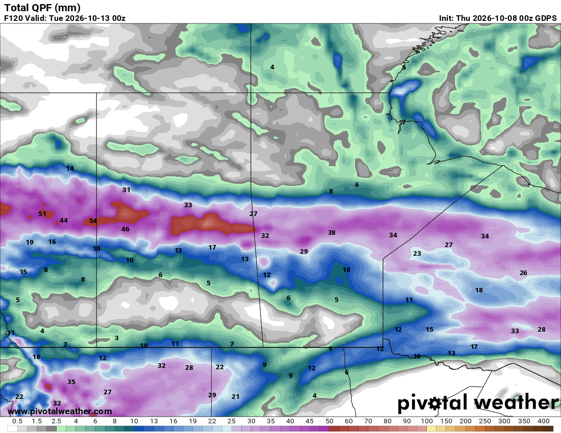
The maps above show only expected SNOWFALL. Elsewhere on the prairies, it will rain. The map below shows total precipitation (rain and snow) expected up until Monday evening:

Harvest Update: The dry stretch paid off in a big way. Alberta reached 60 per cent complete as of September 29, up 21 points in a single week, with the south at 77 per cent and central at 68 per cent, though canola remains the laggard at just 31 per cent province-wide. Saskatchewan posted a similar surge to 63 per cent as of September 28, with the southwest at 84 per cent. Manitoba crossed the halfway mark at 51 per cent the same week, with the northwest and southwest still trailing in the 30s and 40s. The timing isn’t ideal with this storm: canola and later-season crops still out there, especially in Alberta and the slower regions of Manitoba, are exactly what this system threatens.
Worth noting, parts of southern Alberta are now roughly a week past their average first snowfall date, so this isn’t wildly out of season; it’s just arriving with real force.
Of course, when the rain and snow arrive is just as important as how much falls. Here’s the day-by-day breakdown for Alberta, Saskatchewan, Manitoba and the Peace Region.

A strong low-pressure system moves into Alberta today and deepens rapidly as it tracks east, reaching Manitoba by Saturday. Ahead of it, mild air gets pulled north, pushing temperatures into the upper teens and low 20s across Saskatchewan and Manitoba Thursday and Friday. Behind it, much colder air gets pulled south across Alberta late Friday into Saturday, and the combination is expected to bring the first accumulating snow of the season to parts of Alberta. Travel conditions over the long weekend could deteriorate quickly, especially in the west.
Thursday
Peace Region
Rain spreads into the region later today as the approaching low organizes over BC. Steady rain is expected to develop and continue building, with totals potentially reaching 40 mm in spots by Friday. Highs will only reach the high single digits. No frost risk tonight with cloud and rain cover holding temperatures up.
Alberta
Rain begins spreading across areas north of the Yellowhead Highway later today as the low pushes inland, with clouds increasing province-wide. Prior to the system’s arrival, temperatures ahead of the front still reach the upper teens, best across the south. Temperatures may even reach the low 20s along the Milk River Ridge, near the US border. No frost risk tonight.
Saskatchewan
Dry weather is expected today ahead of the incoming system, with precipitation expected to track into central Saskatchewan overnight. Highs should reach the upper teens to low 20s, and increasing cloud cover will prevent any frost risk.
Manitoba
Dry and mild weather continues in Manitoba Thursday. Highs reach the upper teens to low 20s under southerly flow drawing warm air north ahead of the low approaching from the west. That system is still at least a day away. No frost risk.
Friday
Peace Region
Rain continues and begins changing to snow over higher terrain as colder air works in behind the deepening low. This looks like the first accumulating snowfall of the season for higher elevations in and around the Peace region. Lower-lying areas may see a rain-snow mix later in the day. Highs will be in the 2 to 4 degree range, which will prevent any serious accumulations in low-lying areas Friday. Much of the snow that falls will melt, especially on paved surfaces.
Alberta
The low deepens rapidly as it crosses the province Friday. Ahead of it, temperatures can still reach the upper teens, particularly in the south, but a strong push of colder air develops behind the system late today into Saturday. Rain changes to snow over the foothills and mountains, with areas like the higher foothills terrain, including the Hinton and Grande Cache areas, likely seeing a deep coating of heavy, wet snow. Highs vary widely Friday, from near 20 ahead of the front in the south to single digits where the cold air has already arrived.
Saskatchewan
Precipitation moving out of Alberta tracks into central Saskatchewan through the day, starting as rain. Southern Saskatchewan stays on the warm side of the system longer, with highs reaching the upper teens to low 20s, even approaching the mid-20s in the far south. No frost risk in the warm southern sector; central and northern areas should watch for changing conditions as the day progresses.
Manitoba
Still mild and mostly dry through the day as the system approaches from the west, with precipitation reaching central Manitoba and the Interlake later in the day or evening. Southern Manitoba holds onto the warmth, with highs in the upper teens to low 20s. No frost risk.
Saturday
Peace Region
The storm’s core influence is strongest Saturday. Precipitation continues, with accumulating snow likely for many higher-elevation areas and a real chance of snow spreading into lower-lying parts of the region as the cold air mass settles in. Highs will be consistent with Thursday, generally in the low single digits in the hardest-hit areas, with wind adding to the chill. Travel conditions could deteriorate quickly. Be prepared to change plans if you’re wanting to travel Saturday for the Thanksgiving holiday weekend.
Alberta
Accumulating snow is expected across many areas of the province Saturday, with the heaviest totals, potentially exceeding 20 cm, in the western mountain parkland and foothills. Snow may spread into the Calgary-Edmonton corridor and east along the Yellowhead, though amounts there remain less certain and likely lighter than farther west. Highs will likely remain below freezing in the west and mountain parks, while areas farther east will be slightly warmer, with highs into single digits. This is shaping up as a genuinely disruptive travel day for anyone moving through central Alberta.
Saskatchewan
Precipitation tracks into central and northern Saskatchewan, transitioning from rain to wet snow overnight and through the day as cold air wraps into the low. A swath of 20 to 30 mm of precipitation is likely across north-central parts of the province, though snowfall accumulation should be limited by recent warm ground and air temperatures. Southern Saskatchewan stays largely on the dry, warm side of this system, with activity concentrated across the northern half of the province. Regional highs run cold in the north, single digits, while the south holds onto milder air, certainly reaching the high teens, potentially into the 20s.
Manitoba
Precipitation reaches central Manitoba and persists through Saturday night, starting as rain and transitioning to wet snow in the north as colder air wraps in. Southern Manitoba, including most agricultural territory, stays warm and largely dry. Two seasons in one province. It will feel like winter in the north, and summer in the south, with highs still reaching into the 20s, a genuinely pleasant start to the long weekend for that part of the province. No frost risk in the south today; the north sees a sharper temperature drop as the system works through.
Sunday
Peace Region
Snow tapers off from north to south as the system finally clears out, with conditions beginning to improve through the day. It stays chilly behind the departing low, with only a slight warming trend as temperatures reach the mid-single digits. A very cold night is likely behind this system; frost and freezing temperatures are a real concern Sunday night for anything still exposed.
Alberta
Snow continues tapering off from north to south through the day, with clearing conditions developing behind it, though it stays cold. Highs run from near freezing in the mountain parks to low single digits elsewhere. Overnight lows drop well below freezing in many areas. This is a hard frost, not a marginal one, so anything still standing in the field is at risk Sunday night.
Saskatchewan
Colder air now spreads into southern Saskatchewan as the system finally clears the province, a sharp contrast from Friday and Saturday’s warmth. Regional highs fall into the single digits to low teens depending on location. Frost risk climbs significantly overnight, especially in central and northern areas already affected by the system.
Manitoba
Colder air begins pushing into the province today, a noticeable change from the warmth of the past two days, though nothing as dramatic as what Alberta is dealing with. Regional highs ease into the mid to high single digits for Sunday and Monday. Frost risk increases overnight as the colder air mass settles in, worth watching if you have crop still in the field.
Looking beyond…
Recovery starts fairly quickly for the Alberta side of this system. A ridge of high pressure is forecast to begin building back into the province on Thanksgiving Monday, bringing a return to sunshine and daytime highs climbing back into the mid-to-upper teens by Tuesday and Wednesday. That ridge then pushes east, bringing milder air back into Saskatchewan and Manitoba by midweek as well. A weak system tracking south of the Prairies could bring a few more showers or flurries late Monday into Tuesday, but amounts should be light. So this looks like a dramatic but short-lived swing. A real taste of winter over the holiday weekend, followed by a return to more typical mid-October conditions by the middle of next week.
COMPARE: Prairie Weather This Week – October 5 to October 11
The post Prairie Weather This Week – Midweek Update Oct 8 first appeared on Rural Roots Canada.