
Prairie Weather This Week – July 27
This post was originally published on this site.


Prairie Weather (Rural Roots Canada) – Hot and dry in the south, while heavy rain returns to the northern prairies.

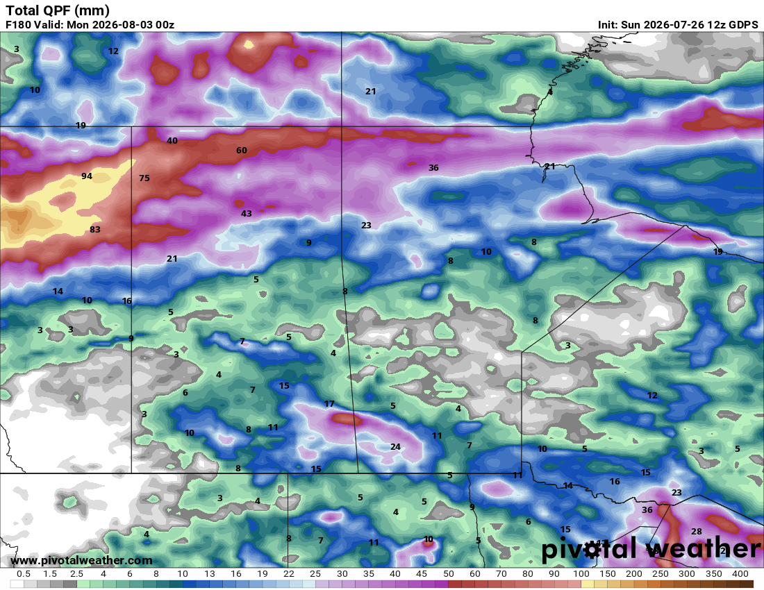
The week’s defining split is straightforward: the north gets the moisture, the south gets the heat. In fact, as the map below shows, southern Alberta may remain completely dry this week, though the chance of a few isolated thunderstorms can’t be ruled out. The map shows rainfall totals up to Sunday evening.

Pacific moisture pushing into northern and central Alberta and Saskatchewan keeps rain chances alive there through the week, while the southern and northeastern Prairies trend dry under a hot, humid airmass that extends all the way into the eastern Arctic. That airmass keeps temperatures above normal through most of the outlook, with a prolonged heat event hanging on for southern Saskatchewan and Manitoba into next weekend. Compared to the past month, this is a somewhat quieter pattern overall, with storm clusters concentrating mostly north of the Yellowhead Highway and drier, more settled conditions further south, aside from a few sharp severe weather flare-ups.
New fires in the Pacific Northwest and southern BC are sending smoke into central and southern Alberta while active fires in northern Saskatchewan and Manitoba continue to challenge air quality there, too.
Monday
Peace Region
Rain moves into northern Alberta today as Pacific moisture feeds into the region, part of a pattern that favours the north with above-average rainfall this week. Expect cooler, showery conditions in the early morning as the rain moves through the Peace en route to northern Alberta. Once the showers pass through, the sky partially clears, and most of the day will be dry. Afternoon highs will be near 20 degrees, which is cooler than average.
Alberta
Rain affects northern Alberta through the morning, with a chance of thunderstorms. By afternoon, storm coverage expands to include south-central Alberta as well. Southeastern Alberta holds a hot temperature threat along the US border through the day as highs climb into the 30s. From south-central Alberta to the north, highs will be in the low to mid-20s, providing a break from the heat. This follows a rough stretch of weather over the weekend, with softball-sized hail reported in west-central Alberta and damaging winds in Edmonton, so if you’re still assessing hail damage from that event, keep an eye out for bruised canola or lodged cereals before any storms later this week complicate the picture further.
Saskatchewan
Thunderstorms develop across central and northern Saskatchewan both morning and afternoon. Showers and storms are also possible in southeastern Saskatchewan in the late afternoon. Southeastern Saskatchewan is also sunny, hot and sticky with high humidex values alongside the hot temperature threat running along the US border. There, temperatures could climb to the low to mid 30s. Elsewhere, expect afternoon highs in the mid to upper 20s.
Manitoba
Thunderstorm chances hold over southern Manitoba in the early morning and return in the afternoon. The more likely spots for the afternoon storms will be south and west of Brandon, and in the Red River Valley. Southern Manitoba shares the humidex threat with southeastern Saskatchewan, as temperatures in the area rise to the high 20s, feeling closer to 30. Where storms do not pop up, it will be mainly sunny through the day.
Tuesday
Peace Region
A calmer day behind Monday’s system, though the north-favouring rain pattern continues to bring periodic shower chances through the region, especially in the afternoon. Good conditions in the morning, though, for catching up on any field work. Afternoon showers could produce 5-10 mm of rain, but severe weather is not expected. Because of the late-day wet weather, high temperatures in the Peace are only expected to reach the high teens or low 20s.
Alberta
Thunderstorms remain possible in central and northern Alberta through the morning and afternoon. Intense storms with heavy rain are possible in the Wood Buffalo area late at night and into early Wednesday morning. Those storms could produce between 30 and 60 mm of rain. A few fires are burning near Fox Lake, and this rain will be most helpful. The area is forested, not agricultural. The southern part of the province will remain dry, with bright sunshine. Southeastern Alberta holds onto hot temperatures, in the low to mid 30s, and smoke is expected to affect air quality in central and southern areas. A wind gust threat develops specifically for Crowsnest Pass northeast toward Nobleford in the afternoon, worth noting if you’re trucking grain or hay through that corridor or have equipment parked in exposed areas there. Other than the Peace, which will be noticeably cooler, temperatures in the rest of Alberta should reach the low to mid 20s.
Saskatchewan
Morning storms can be expected in central and northern parts of the province, with calmer weather for all regions in the Afternoon. Southern Saskatchewan will be under both humidex and hot temperature thresholds. That said, south of the Trans Canada Highway, temperatures will climb into the low 30s, reaching the high 20s elsewhere in the province. This is a good stretch to front-load any spraying or field walking into the cooler morning hours before the heat and haze set in.
Manitoba
Thunderstorms continue across the southern half of the province in the morning, with only isolated activity by afternoon. Southern Manitoba shares the humidex and hot temperature threat with southern Saskatchewan, though it won’t be quite as hot, as temperatures are expected to peak at or just below 30 degrees. If you find yourself in one of those isolated afternoon storms, keep an eye on hail risk in any canola or cereal fields approaching harvest maturity, since standing crop this time of year has little give left in it.
Wednesday
Peace Region
Rain returns to northern Alberta both morning and afternoon, keeping the moisture surplus building in the north while the south stays dry and hot. If your fields are already saturated from earlier in the season, watch for standing water in low spots and consider whether any remaining nitrogen applications need adjusting for potential loss.
Alberta
Morning rain affects northern Alberta, with thunderstorms continuing through the northeastern parts of the province. The rest of the province should stay dry. Southeastern Alberta continues under a hot temperature threat, joined by a humidex threat by afternoon. Temperatures in the southeast will climb to the low 30s. By contrast, north of the Yellowhead Highway, it will be at least 10 degrees cooler. In between, in central Alberta, expect highs in the low to mid-20s. The wind gust threat holds for Crowsnest Pass and Pincher Creek through the morning, a second straight day for that area. The wind is expected to die down by afternoon.
Saskatchewan
Thunderstorms track across the province through the early part of the day, with southern Saskatchewan under both humidex and hot temperature thresholds. Regina’s forecast shows humidex values near 34°C with hazy skies from wildfire smoke, a combination that makes any outdoor labour considerably tougher than the temperature alone would suggest. All across southern Saskatchewan, highs will reach the low to mid 30s, even without taking humidity into account. Take the usual heat precautions seriously this week: frequent water breaks, shade when possible, and extra vigilance checking on anyone working alone in the field. It will be a bit cooler in central and northern regions, with highs in the mid-20s.
Manitoba
Thunderstorms continue on the western side of the province and in the north. While they can’t be ruled out anywhere, storms are much less likely in the south, east of Brandon. The humidex threat is expected to cover the southern half of the province by afternoon, including the Interlake. Winnipeg’s forecast holds near 31°C with a mix of sun and cloud, consistent with the sustained heat further south and west.
Thursday
Peace Region
A low-pressure system off the west coast will push some rain into BC and cloud cover for the Peace Region. It is expected to be a dry day, but with little sunshine. Temperatures will climb to the low 20s, making for comfortable conditions for outdoor work. The northern half of the Peace Region may see a bit more sunshine than the south.
Alberta
It will be quiet throughout most of the day in Alberta, with thunderstorms developing in the afternoon near Edmonton and to the north. Southeastern Alberta remains hot, with humidex values adding to the discomfort. Yet again, temperatures in southeastern Alberta will climb to the low 30s, with added humidity close to the Saskatchewan boundary. The remainder of the province will reach highs in the low to mid 20s.
Saskatchewan
Rain reaches northern Saskatchewan due to a tightly wrapped low-pressure system just north of the province. That system will also cause strong wind gusts in northern Saskatchewan, mostly in sparsely inhabited forests. Thunderstorms can’t be ruled out in southeastern Saskatchewan in the morning, and southern Saskatchewan in the afternoon. The storms in the south will be fueled by heat. With highs in the mid-30s, southern Saskatchewan is now into its second week of the heat event. Through central and northern regions, highs should reach the mid to high 20s.
Manitoba: Rain affects northern and southeastern Manitoba, with stronger thunderstorms expected here than elsewhere in the province today. Southern Manitoba and the Interlake hold onto humidex and hot temperature thresholds, and a wind gust threat develops for northern Manitoba in the afternoon. If you’re in the path of the stronger cells, this is a day to have hail coverage top of mind and to secure anything loose around the yard ahead of the wind threat.
Friday
Peace Region
Continued dry weather seems likely. A good window to get equipment out if the ground has dried enough to support it. Afternoon highs will reach the low 20s, making for comfortable weather, though, like Thursday, the sky is expected to remain cloudy.
Alberta
Thunderstorms continue across the province, especially early in the day. Southeastern Alberta remains under a hot temperature threshold through the day and a humidex threshold by afternoon. South of the Trans Canada Highway, afternoon temperatures are expected to reach 31 to 34 degrees. Mid-to-high 20s can be expected elsewhere in the province. Significant storms are not expected, though there may be some early-day rain due to the storms.
Saskatchewan
Rain reaches southeastern Saskatchewan near the US border, with the potential for thunderstorms province-wide. The map below shows rainfall amounts expected Friday, and it won’t be much:

Humidex and hot temperature thresholds hold across the south. In southwestern Saskatchewan, in places such as Val Marie and Eastend, temperatures will climb to the low 30s. Elsewhere, expect highs in the 20s.
Manitoba
Thunderstorms produce rain in southwestern Manitoba near the US border by afternoon alongside southern Saskatchewan. As the above map shows, west of Portage La Prairie, some areas could receive around 20 mm of rain, falling in the morning. The weather will become dry in the afternoon, with sunshine returning. The early-day rain will cool the atmosphere, so afternoon highs in southern Manitoba will be in the mid 20s, close to the long-term average.
Saturday and Sunday
Peace Region
Rain returns to the Peace Region Saturday and Sunday, as a strong low-pressure system begins to build in northern Alberta, shooting some moisture back toward the Peace. Circulation around the low will turn the flow to the north, so it will be windier, with a wind gust threat developing. The map below shows the expected rain accumulation in Alberta and BC through the weekend. The Peace Region can expect 20-25 mm of rain. Some areas, shaded in yellow, may get well over 100 mm during the weekend alone!

Along with the wet weather and strong wind, it will be cool, with highs only reaching the mid-teens each day.
Alberta
As the map above shows, the weekend brings continued rain over northern Alberta. Southern Alberta holds onto hot temperatures with humidex adding to the load in the southeast. This marks close to two weeks of sustained heat for the southern half of the province, so don’t let your guard down on livestock water systems as the calendar turns toward August. Sunday carries that rain into the north again, with thunderstorms still possible province-wide and southern Alberta staying hot. Especially Saturday, when highs in Drumheller, Milk River, Brooks, and Medicine Hat could reach 35 to 37 degrees. The wind gust threat covers the province both morning and afternoon, so secure loose equipment, tarps, and bin lids before the afternoon gusts pick up.
Saskatchewan
Saturday sees thunderstorms continue across the province with southern Saskatchewan under both humidex and hot temperature thresholds, now close to two full weeks into a prolonged heat event. Saturday will be a scorcher in southern Saskatchewan, with highs between 33 and 37 degrees. Highs will reach the high 20s in central Saskatchewan. Sunday will be about 5 degrees cooler across the province. A strong low-pressure system in northern Alberta will send rain across northern Saskatchewan over the weekend. If you haven’t had a chance to check irrigation equipment or watering troughs for capacity, this weekend is the time. Sunday brings rain expanding into the north by afternoon, with thunderstorms continuing province-wide. Southern Saskatchewan holds onto humidex and hot temperature thresholds through the day, with a wind gust threat over the north both morning and afternoon.
Manitoba
Saturday keeps thunderstorms going province-wide, especially early in the day. Southern Manitoba shares the humidex and hot temperature threat carried by its neighbours to the west, and little relief in sight before the weekend wraps up. Sunday brings rain to the province by afternoon as thunderstorms develop along a front connected to a powerful low-pressure system north of Fort McMurray, Alberta. Southern Manitoba can expect temperatures in the mid to high 20s on Saturday, and the low 30s on Sunday.
READ:
FCC offering financial relief to producers hit by flooding and delayed field work
The post Prairie Weather This Week – July 27 first appeared on Rural Roots Canada.