Prairie Weather This Week – June 1
This post was originally published on this site.


Prairie Weather (Rural Roots Canada) – Wet weather soaks fields, as farmers try to finish seeding.
June 1st is the first day of meteorological summer, though many would argue it began a bit early this year with scorching May heat in Saskatchewan and Manitoba. Meteorological summer consists of the three hottest months of the year: June, July, and August. And with El Niño continuing to develop, the expectation is for a hot, dry summer across the Canadian prairie.
It has been anything but hot and dry in Alberta over the weekend, and the wet, cool weather continues into the early part of the week.
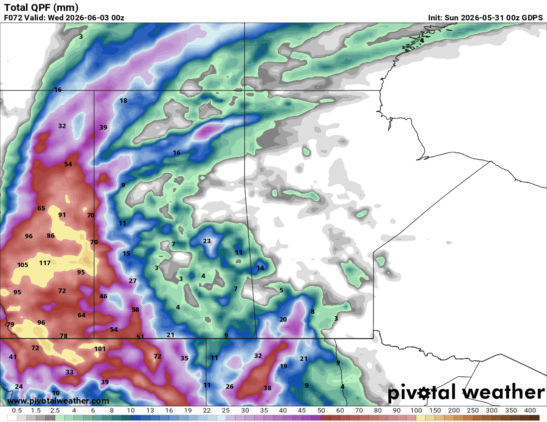
Alberta and western Saskatchewan are absorbing a significant rainfall event this week. The amounts being forecast, 50 to 100mm for a large portion of Alberta, with isolated areas potentially approaching 150mm, are welcome in the context of a building El Niño pattern that raises long-term drought risk for the prairies, but will also close seeding windows for weeks in the most affected areas.
Areas that see heavy rain will have their seeding window close for a while into early June before soils become dry enough to work again, and significant delays are a concern for production if remaining acres have not been completed before the heaviest rains arrive. Saskatchewan was at 52% seeded as of the May 25 report, behind both the five-year average of 74% and the 10-year average of 77%, with the northeast and east-central regions at just 25-26%. The warm, dry window late this week, on Thursday and Friday, is the most critical opportunity of the week for those regions. Use it fully.

The map below shows total rainfall expected by early evening Tuesday:

The numbers on the above map may be a bit high for Alberta. Regardless, this is a significant rain event that will considerably set back field work for several days.
As the map above shows, most of Saskatchewan will get some rain, but in far lesser amounts. And southwestern Manitoba is in for enough rainfall to disrupt field work. The Peace Region in Alberta and northeastern BC will see clouds, but remain dry through the early week.
Timeline for Rain (And Snow!)
The two maps below show the week’s weather at a glance across Western Canada. The first map shows Alberta and BC. Note the Peace Region stays dry early in the week, with rain coming in on Thursday. Also note the snow (blue) in the mountain parks early in the week, returning on the weekend.

Having the snow fall instead of rain in the mountain parks is a good thing. The floods of 2013 were due in part to heavy rain falling on mountain snow, accelerating its melt. Snow falling on snow won’t do that.
The second map indicates that for the prairies, the end of the early week storm doesn’t necessarily mean the end of rain. More is expected later in the week. Though that rain will be lighter, it may extend the disruption to field work:

Monday
Peace Region
Monday is a workable day across much of the Peace. The heavy rainfall system is centred well to the south, and the Peace sits outside the main moisture plume. Expect mostly cloudy skies with highs in the 18 to 20 degree range and light winds. The region remains dry Monday and Tuesday as the cutoff low stays anchored over Wyoming and its moisture feeds up the eastern slopes rather than reaching this far northwest. If you have seeding acres still to finish, Monday is a genuine opportunity. Keep an eye on the southern horizon, but the system’s reach does not extend to the Peace in the near term.
Alberta
Heavy rain is expected in much of Alberta through to Wednesday morning, and total accumulations of near 100 mm are possible. Strong northerly winds compound the situation across central and southern Alberta, where gusts up to 90 km/h are possible on Monday. Much of central and southern Alberta should expect gusts of at least 70 km/h through the day. The combination of heavy rain, wind, and rapidly cooling temperatures makes Monday a dangerous day to be in the field across the affected zones.
Thunderstorms are possible along the eastern edge of the system, mainly through eastern Alberta and northern Saskatchewan. Snow levels are dropping in the mountain parks, with 5-10cm expected in the foothills and front ranges and higher amounts at greater elevations. The Alberta River Forecast Centre is actively monitoring stream flows, and flooding is possible near creeks and coulees by Monday evening. Do not drive through flooded roadways.
Saskatchewan
Heat warnings persist across portions of northeastern Saskatchewan on Monday as the warm air mass holds on a little longer before the cold front pushes through. Highs in the northeast could still reach 30 degrees, a stark contrast to what is unfolding to the west. The trough and cold front extending southward through the province will focus convection on Monday afternoon across southwestern Saskatchewan. Southwestern Saskatchewan has already received localized rainfall totals of 50-60mm in recent days, and further accumulations are expected as waves of convective rainfall continue. Some of the convective storms could border on severe, with locally heavy rainfall and nickel-to-quarter-sized hail as the primary threats. There is an air quality warning near Prince Albert due to forest fire smoke. Saskatchewan seeding reached 52% complete as of the May 19-25 reporting period, still behind the five-year average of 74% and the 10-year average of 77%. Any remaining unseeded acres in the west and southwest are now delayed again as wet soils need time to recover before equipment can move.
Manitoba
Heat warnings continue across southern Manitoba on Monday as the upper ridge, now centred over southern Manitoba and northwestern Ontario, keeps warm air firmly in place. Highs reaching 32 to 34 degrees are possible again on Monday in southern areas before the pattern gradually moderates. A few non-severe thunderstorms will develop across northern and central Manitoba with daytime heating along the fringe of the upper ridge. These will not be organized or severe, but localized heavy rain is possible wherever a cell sits. Eastern Manitoba stays hot and largely dry on Monday. Livestock water needs are high, and cumulative heat stress on crops that have been baking since mid-May deserves attention this week.
Tuesday
Peace Region
Tuesday remains dry across the Peace, with the main precipitation system continuing to track well to the south and east. Expect highs in the 17 to 19 degree range under a mix of sun and cloud. This is the second consecutive workable day for the region, and producers should be making the most of it. Fields in the Peace have not been impacted by the event affecting central and southern Alberta, so conditions should be reasonable for seeding and fieldwork. Light winds through the day.
Alberta
The upper low remains entrenched over the region on Tuesday. Rain continues through Tuesday, with strong northwesterly winds near 25 knots gusting to 40 knots persisting through the day before gradually easing Tuesday evening. Temperatures across most of the province will struggle to reach double digits. This is the peak accumulation period for many areas. Producers near the Oldman River Basin and areas east of Calgary, Rocky Mountain House, and Lesser Slave Lake are in the zone forecast, with the highest totals, potentially exceeding 100mm, before this is done.
Watch the Alberta River Forecast Centre updates carefully if you farm near any river or creek bottom. Equipment parked in low areas should be moved to higher ground. Temperatures at mountain elevations will remain below zero, and snow will fall, potentially slowing the runoff.
Saskatchewan
The upper low begins to stall over western Saskatchewan on Tuesday, bringing continued waves of rain to the southwest. Saskatoon cools to around 18-22°C after the cold front pushes through, a dramatic change from Monday’s heat in the northeast. The west-central and southwest regions are absorbing significant rainfall totals that will push topsoil moisture to surplus levels in areas already near capacity from recent rains. The east-central and northeast, where seeding progress was still at 25-26% two weeks ago, see less organized precipitation on Tuesday and remain far behind schedule. Those areas need a warm, dry window once this system exits mid-week.
Manitoba
The heat begins to moderate across Manitoba on Tuesday as the upper ridge shifts further east. There could be a reverse temperature trend, in which it cools down in the afternoon, rather than heats up. Temperatures drop from the low 30s toward the mid-20s through the day. Isolated to scattered thunderstorms remain possible across central and southern Manitoba along the frontal boundary as it pushes eastward. The fire situation near west-central Manitoba continues, and winds accompanying any storms could spread fire activity. Check fire and air quality bulletins before outdoor work in that area.
Wednesday
Peace Region
While the rest of the province has had a wet week, the Peace has stayed dry until Wednesday. It will be mostly cloudy, with a chance of showers developing as the trailing edge of the Alberta system inches northward. Highs will reach the mid to upper teens. Any precipitation should be light and brief. Fields remain in workable shape, and seeding operations can continue where fit. Wednesday is a transition day for the Peace, with somewhat improved conditions on Thursday.
Alberta
Rain is expected to continue in Edmonton through to early Wednesday morning before conditions improve. By midday Wednesday, skies begin to break across southern and central Alberta, and temperatures recover to the mid-teens across the province. Standing water will be widespread in low spots, and fields that received the highest rainfall totals will be saturated for days. Do not rush heavy equipment onto fields before the soil profile has had time to drain. Canola and cereals seeded before the rains arrived will have received more than adequate germination moisture. The concern now shifts to ponding damage and the risk of soil crusting on clay soils once things dry and warm.
Saskatchewan
The upper low finally begins to lift off western Saskatchewan on Wednesday. The southwest and west-central regions start to dry out but carry surplus to excessive topsoil moisture after potentially 60-80mm of accumulated rain over the past five days in some spots. Temperatures recover to the low-to-mid 20s across most of the province by Wednesday afternoon. A few lingering showers are possible in the west through midday. The east and northeast of the province have been largely spared the heaviest rainfall, but there will be lingering showers through the day.
Manitoba
Temperatures are moderate-to-low 20s across Manitoba on Wednesday as the ridge weakens and a surface low-pressure system moves through. The low will provide rain to the northern half of the province. There will also be rain in the south. It begins in Westman, moves to the Red River Valley by afternoon, and intensifies in the evening. Conditions are largely dry and partly cloudy. The heat wave is effectively over, replaced by rainfall. The rain will be beneficial as it will replenish soil moisture lost to evaporation in the heat wave. However, it will be detrimental in that it will keep farmers off the fields.
Thursday
Peace Region
A mix of sun and cloud with highs of 18-19°C. Conditions are solid for fieldwork on Thursday and Friday in the Peace. With two dry days behind them and two more ahead, Peace Region producers should be moving on any remaining seeding acres. Soil conditions are favourable, and soil temperatures are adequate for canola germination at this point in the season.
Alberta
Thursday brings one of the better days of the week for central and southern Alberta. Calgary recovers to highs back in the low 20s by mid-week, with Edmonton making a similar climb. Thursday marks the beginning of a genuine drying window before the next system arrives around June 7. Fields that took 30-50mm should begin to firm on lighter soils by Thursday. Areas that received 75-100mm will need more time, particularly in the south and along the eastern slopes. Soil crusting is a real risk on clay and silt loam soils as they dry quickly under the sun and wind after heavy rain. Watch for emergence issues where a hard crust has formed over seeded fields.
Saskatchewan
Thursday sits in the recovery window with highs near 21 to 23 degrees and mostly sunny conditions across the province. This is the best field day of the week for central and eastern Saskatchewan, where the recent rains were lighter, and soils are most likely to be workable. The northeast and east-central, still carrying below-average seeding progress, have their best opportunity of the week on Thursday. Every hour of fit conditions counts. Canola seeded in late May that survived the heat wave is now germinating rapidly in warm, moist soils across the southwest and west-central.
Manitoba
Mostly cloudy Thursday with highs in the mid-teens across the province, with a bit more cloud in the south. And, some areas will get rain:

For a fair amount of southern Manitoba’s agricultural land, it will be a dry day with most of the moisture in the Interlake region. For many southern Manitoba farms, this is a clean, workable day. Western Manitoba carries more moisture from the edges of the system and will need more drying time. If any seeding remains and, if weather permits, Thursday is the day to push hard.
Friday
Peace Region
The sky bears watching on Friday, as it will be unstable, and there is a risk of showers forming in the afternoon. They will likely be isolated, with hit-and-miss showers, with minimal accumulation. Highs will reach the high teens, but likely fall short of 20. The window that served the Peace well Monday through Thursday begins to narrow on Friday. Get equipment moving early in the day, before shower chances increase through the afternoon.
Alberta
Another trough is forecast to push into the region over the weekend, bringing more organized precipitation and another round of potential severe thunderstorms. Ahead of all that, Friday carries an increasing shower and thunderstorm risk for Alberta, particularly through the afternoon. This system arrives from the west with a faster, more organized flow compared to the slow-moving cutoff low that dominated earlier in the week, which means the severe weather setup could be more textbook. Hail, heavy rain, and damaging winds are all possible should the storms intensify on Friday afternoon. The Rocky Mountain House and Red Deer regions should be watched closely. Do not leave equipment exposed in the field on Friday afternoon without a shelter plan.
Saskatchewan
Western and central Saskatchewan see increasing shower and thunderstorm chances on Friday as the Alberta system begins to interact with the edge of the upper ridge. Eastern Saskatchewan and southern Manitoba stay drier and warmer on Friday, with temperatures still in the mid-to-upper 20s. If you have remaining canola or pulse acres in the northeast, Friday is a legitimate seeding day. Soil temperatures across the region are elevated after the heat wave, which favours rapid germination once seed is in the ground.
Manitoba
Mostly sunny with highs of 24 to 26 degrees on Friday. The province largely stays outside the main precipitation track. Isolated afternoon thunderstorms cannot be ruled out near the western edge of the province, but widespread rain is not expected. It will be a strong field day for most of Manitoba.
Saturday and Sunday
Peace Region
The unsettled pattern spreads northward into the Peace through the weekend as the next system works through. Showers are not likely, but at the same time, are possible Saturday and Sunday with highs in the mid-teens. This follows a productive stretch of dry conditions earlier in the week. Check back at this site on Thursday for updated timing on precipitation amounts, as confidence in specifics drops at this range.
Alberta
Saturday and Sunday carry a continued risk of showers and thunderstorms as the new trough works through the province. A series of low-pressure systems is forecast to develop over the western United States and track northward through Alberta, with another disturbance potentially arriving around the middle of next week.
The cumulative rain total for Alberta from the entire event period, late Saturday, May 30, through to next week, is forecast at 50-100mm for a large swath of the province, with some areas along the eastern slopes and southern foothills approaching or exceeding 100mm. Flooding risk along the Bow, Red Deer, and North Saskatchewan River systems should be monitored through the weekend. Check the Alberta River Forecast Centre for updated stream flow information and stay off flooded road crossings.
Saskatchewan
Western and central Saskatchewan see the greatest storm risk through the weekend as the new system interacts with the remnant ridge. Eastern Saskatchewan holds on to warmer and drier conditions longer. Saturday highs will reach the mid-20s across the province before the next round of showers moves in by Sunday. The east and northeast remain the province’s best bet for seeding progress through the weekend. For southwestern and west-central producers, the immediate priority shifts from seeding to monitoring emerged crops for flooding and ponding damage. Assess canola and pulse fields for soil crusting and standing water before the next rain event, which adds to what is already surplus topsoil moisture in many areas.
Manitoba
Manitoba temperatures gradually moderate from the low 30s at the start of the week down to the mid 20s by late in the week, with the warmest conditions persisting longest in the east. Saturday and Sunday see highs of 23 to 26 degrees with a mix of sun and cloud and isolated afternoon thunderstorm chances as the frontal system approaches from the west. Winnipeg and eastern Manitoba stay largely dry through the weekend.
This is the time for Manitoba producers with remaining seeding acres to be working. With the province at 55% seeded before the heat wave and incoming rainfall, and an El Niño pattern carrying a higher risk of a drier, hotter summer on the horizon, getting every acre in the ground while conditions allow is the priority.
Event Forecast
Manitoba Summer Fair, Keystone Centre, Brandon, MB, June 3 to June 7
June 3 – Mostly sunny, slight chance of isolated showers, wind west 20, high 20
June 4 – Mostly cloudy, slight chance of showers, wind ENE 15, high 16
June 5 – A mix of sun and cloud, wind south 20 gusting to 30, high 24
June 6 – Sunny, light wind, high 28
June 7 – Sunny, increasing afternoon cloud, chance of evening thunderstorms, possibly severe. Strong wind gusts in the thunderstorms, high 33
The post Prairie Weather This Week – June 1 first appeared on Rural Roots Canada.