Prairie Weather This Week – Midweek Update June 25
This post was originally published on this site.


Prairie Weather (Rural Roots Canada) – The weather pattern flips, and rain returns to saturated ground across the prairies
An upper-level ridge anchored along the British Columbia-Alberta border is providing warm and mostly stable conditions to the western Prairies early in the period, while a broad upper trough dominates the eastern Prairies. However, this pattern will undergo a major shift over the weekend.
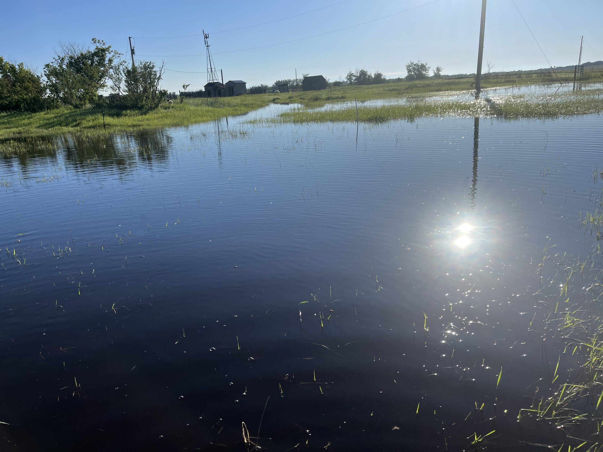
A developing low-pressure system over the Peace Region on Friday will track southeastward and intensify significantly over southeastern Alberta by Saturday. This system is forecast to bring widespread rainfall (30 to 60 mm) to central and southern Alberta, prompting localized flooding concerns, especially in areas where the soil is saturated from last weekend’s rain. East of Edmonton, this field was submerged after last weekend, and more rain is headed into the same area this weekend:

Further east, an energetic southwest flow aloft establishing late Friday will combine with building heat and humidity to trigger multi-day severe thunderstorm threats across southern Saskatchewan and southern Manitoba through the weekend.
In conversations over the past few days, it’s become apparent that whether the rain is welcome varies from region to region, even from farm to farm. Even though there has been considerable rainfall in southern Alberta, there have also been consistently strong winds, which tend to dry things out rather quickly. In central regions, the rainfall may have led to some overland flooding, but on a more positive note, dugouts that have been low for months or even years have filled up again, and rivers and streams have filled nicely. This weekend’s rainfall, though, will undoubtedly lead to high streamflows. As of this writing, Thursday morning, there are several high streamflow advisories throughout central Alberta. The latest information can be accessed here: Alberta Rivers.
Thursday
Strong thunderstorms are possible in two Alberta regions – the Peace and the south. The map below shows areas of thunderstorm potential in the mid to late afternoon, with the strongest storms possible in the areas circled in red:

Peace Region
A developing trough across northern Alberta and northeastern British Columbia will trigger scattered afternoon and evening thunderstorms. Some storms may produce locally heavy rain, small hail, and gusty winds. A severe storm or two can’t be ruled out. The Peace will be the warmest part of the region, with highs reaching the high 20s. That heat will help energize any storms that develop in the afternoon. It goes without saying that localized rainfall will benefit crops and pastures, though isolated hail could cause minor damage where stronger cells develop.
Alberta
Most of central and southern Alberta enjoys another pleasant summer day with sunshine, warm temperatures, and only isolated afternoon thunderstorms developing near the foothills. Northern Alberta remains considerably warmer, with temperatures climbing well above seasonal averages into the mid to high 20s. A few thunderstorms are expected across the northwest, where stronger instability may support isolated severe storms capable of large hail and heavy downpours. Stronger mid-afternoon thunderstorms may develop in southern Alberta, particularly near Nanton and Claresholm. Until then, there are excellent spraying and haying conditions across much of southern Alberta. Producers in the foothills and northwest should monitor for late-day thunderstorms.
Saskatchewan
Warm temperatures and daytime heating will trigger scattered afternoon thunderstorms, particularly across central Saskatchewan. Most storms remain below severe limits, though an isolated stronger storm cannot be ruled out. Good growing conditions continue, though localized thunderstorms may briefly interrupt field operations. Heat is needed, as cooler-than-average spring weather has harmed crop growth. Across the province Thursday, highs are expected to reach the low to mid 2os.
Manitoba
Scattered showers and thunderstorms develop during the afternoon and evening, especially across central and northern regions. Late in the day, the showers and isolated storms will head into southern Manitoba, and temperatures will climb to the high teens and low 20s. Brandon and Winnipeg could reach the low 20s, depending on how long the rain holds off. Humidity continues to increase. Generally favourable conditions for agriculture, although localized heavy downpours may create uneven soil moisture conditions.
Friday
Peace Region
Attention shifts to a developing low-pressure system that is expected to organize over the Peace Region during the afternoon. Cloud cover increases through the morning, followed by expanding areas of showers and thunderstorms during the afternoon and evening. Rainfall becomes increasingly widespread overnight as the system strengthens. Overall, most areas in the Alberta Peace region can expect 5-10 mm of rain on Friday, with 15-20 mm possible on the British Columbia side. This may be the last meaningful fieldwork window before a wetter pattern becomes established for the weekend. Producers should anticipate increasing delays by late afternoon and evening. The afternoon rain will keep highs in the mid-teens.
Alberta
Weather conditions become increasingly unsettled as the day progresses. Southern Alberta may begin the day with partial sunshine and relatively quiet conditions. However, showers and thunderstorms are expected to become more numerous through the afternoon and evening as the developing low approaches. Northern Alberta remains very warm. High temperatures in some areas may approach or exceed 30°C. Combined with increasing humidity, this will create significant instability and support thunderstorm development. The strongest storms Friday appear most likely across western Alberta and areas adjacent to the Peace Region. Crop growth remains highly favourable. However, producers planning haying, spraying, or silage operations should be aware that weather conditions deteriorate significantly late in the day, particularly in central Alberta. While the north will be hot, temperatures in central and southern regions will likely peak in the low to mid-20s.
Saskatchewan
The province remains positioned between the Alberta storm system and the eastern trough. Central Saskatchewan may see scattered showers and thunderstorms through the morning and afternoon, while southern Saskatchewan remains largely warm and humid. Across the province, expect highs in the 25 to 27 degree range. While severe weather is unlikely in Saskatchewan over the weekend, non-severe thunderstorms could pop up randomly in the afternoon. The green dots on the map below indicate the possibility of isolated afternoon showers and storms. The atmosphere continues to become increasingly unstable ahead of the weekend.

Good growing conditions continue. Increasing humidity may slow hay drying rates and reduce spraying opportunities during overnight and early morning periods.
Manitoba
As the map above indicates, scattered showers and thundershowers develop across Manitoba in the afternoon, with perhaps the greatest chance being in southwestern Manitoba and the far north. It will be humid in the south, with relative humidity above 80 percent through the day, giving the atmosphere a “juicy” feel. With increasing moisture levels and light winds, overnight fog becomes increasingly likely in areas that receive rainfall. Afternoon temperatures will reach the low 2os, with plenty of local variation due to the timing and location of the showers and storms. Soil moisture reserves continue to improve. However, repeated rainfall may begin creating challenges for hay producers in some districts.
Saturday
Peace Region
Periods of rain continue as the low-pressure system strengthens and shifts southeastward. The Peace region can expect 20 to 30 mm of rain on Saturday, and embedded thunderstorms are possible. Field work will pause on Saturday due to the rain, and localized flooding can’t be ruled out, particularly in lower-lying areas and fields that have already received substantial rainfall in June. Because of the rain, highs will only reach the mid-teens.
Alberta
Saturday appears likely to be the wettest day of the weekend for much of Alberta. Rain develops across central and southeastern portions of the province during the morning and expands through the afternoon and evening. Thunderstorms will be embedded within broader areas of precipitation. The heaviest rainfall may develop across central Alberta, although confidence in exact placement remains moderate. The map below shows areas that got soaked last weekend will get soaked again Saturday:

Due to the rain, highs in central and southern Alberta will only reach 12 to 16 degrees. By contrast, hot weather continues in northern Alberta, with highs near 30. Moisture will be welcomed in many areas, particularly where crops have begun drawing heavily on soil reserves. However, haying operations may effectively come to a halt, and localized ponding becomes possible in poorly drained fields.
Saskatchewan
Thunderstorm activity becomes more widespread during the afternoon and evening as stronger southwest flow develops aloft. Southern Saskatchewan appears most likely to experience stronger storms, especially the area between the Trans-Canada Highway and the US border. The environment will become increasingly favourable for hail, strong winds, and localized heavy rainfall. Rainfall will generally benefit crops, but producers should begin monitoring severe weather forecasts closely, particularly in southern regions. South of the Yellowhead Highway, it will be cool with highs in the teens and low 20s. In northern Saskatchewan, it will be very warm, with temperatures climbing to the high 20s. The map below shows possible rainfall totals Saturday in Saskatchewan and Manitoba:

Manitoba
Thunderstorm activity continues across much of the province, particularly western Manitoba, where the showers and storms will limit high temperatures to near or below 20 degrees. The map above shows expected rainfall Saturday. Elsewhere in southeastern, central, and northern Manitoba, it will be a warmer day with highs in the mid to high 20s. Rainfall coverage gradually expands through the day as moisture streams northward. Continued moisture supports crop development, though opportunities for haying become increasingly limited.
Sunday
Peace Region
A low-pressure system in Saskatchewan will continue to send showers back into Alberta. The Peace region is on the western end of the precipitation, and showers will gradually diminish as the system moves eastward, although scattered precipitation remains likely throughout the day. Wet soils may continue limiting equipment access despite the gradually improving weather conditions. Forecasting temperatures for Sunday is tricky, as it depends on how fast the rain dissipates, when, and where. Where the rain ends early, temperatures could climb to the mid-20s. Where the rain lingers, it will likely be about 10 degrees cooler.
Alberta
The storm system reaches peak intensity across parts of the province. Widespread rain is expected across much of central and southern Alberta, with the heaviest rainfall likely centred somewhere within central Alberta, probably west of Highway 2 between Red Deer and Edmonton. Some locations could receive event totals reaching 50 to 70 mm by the end of the weekend. Thunderstorms remain possible across much of the province, while northern Alberta continues to experience unusually high temperatures. Strong wind gusts may also develop across central Alberta, possibly making for a significantly stormy day. This rainfall event will provide significant moisture recharge for crops and pastures. However, localized flooding, standing water, washouts, and delayed field operations become increasingly likely in the wettest areas.
Saskatchewan
Showers and thunderstorms continue across much of the province. Southern Saskatchewan remains the primary area of concern for stronger storms. Enhanced wind fields and abundant moisture suggest some storms could become severe. Overall, across central and southern Saskatchewan, expect 15 to 25 mm of rain. Highs will be in the 16 to 18 degree range. Central Saskatchewan may also experience strong wind gusts. The combination of moisture and heat remains favourable for crop development, but hail and localized flooding pose increasing risks.
Manitoba
Sunday currently appears to present the greatest severe weather potential of the forecast period. Thunderstorms are expected across much of southern Manitoba, with the highest risk south of the Trans-Canada Highway. Strong instability, abundant moisture, and strengthening upper-level winds could support severe thunderstorms capable of large hail, damaging winds, torrential rainfall, and localized flooding. There is plenty of uncertainty surrounding exactly where the most abundant rainfall will occur, but producers across southern Manitoba should prepare for a heavy rain day. Remain alert for severe weather watches and warnings from Environment Canada. Localized hail damage and excess moisture are the primary concerns.
EVENT FORECASTS
Alberta Beekeepers Field Day, Beaverlodge, AB, June 26
June 26: Chance of afternoon showers or thundershowers, high 24
Manitoba Agricultural Farm and Garden Show, Keystone Centre, Brandon MB, June 27, 28
June 27: Cloudy morning, afternoon rain and thunderstorms, high 21
June 28: Showers, chance of thundershowers, high 24
LISTEN: Flooding Concerns on parts of the Prairies
The post Prairie Weather This Week – Midweek Update June 25 first appeared on Rural Roots Canada.