Prairie Weather This Week – Midweek Update May 14
This post was originally published on this site.


Prairie Weather (Rural Roots Canada) – Saskatchewan’s stormy. True to its reputation in Alberta, the May long weekend includes SNOW.
Saskatchewan Storm – an intense low-pressure system is sitting over central Saskatchewan right now, and it will be the dominant weather story for the next several days. This system is producing heavy rain, dangerous winds, and in some areas, snow. A cold front will trail behind it, dragging unseasonably cool air across the Prairies heading into the May long weekend. Field work will be essentially impossible across much of Saskatchewan and southern Manitoba on Thursday. Plan your weekend around low temperatures and the possibility of more unsettled weather for the eastern Prairies early next week.

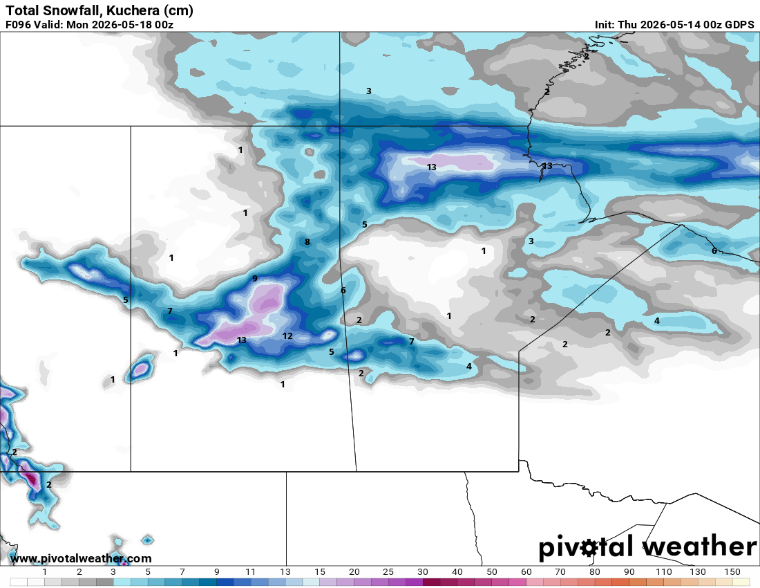
The map below shows snowfall expected up to Sunday night. The long weekend that signals the unofficial start of summer will feel more like winter, especially in Saskatchewan:

Thursday
Peace Region
The Saskatchewan storm’s outer moisture shield is reaching into the northern Peace today. Expect cloudy skies with rain developing. Grande Prairie and Beaverlodge will likely see rain through the day, with northwest winds gusting to 40 km/h by this afternoon. Heavier rain will fall to the north, closer to Spirit River. Temperatures will sit in the mid-teens before dropping as the evening progresses. Any fieldwork you had planned today should be finished as early as possible. This is not necessarily welcome rainfall. Soil that is already wet will not benefit from more.
Alberta
The low is directly impacting central and southern Alberta today. Wind warnings are in effect for the central and southern portions of the province, with gusts reaching 100 km/h in some areas. These are not marginal winds. High-sided equipment, grain bins, and temporary structures are all at risk. Rainfall warnings are in effect for a wide northern swath, with 20 to 30 mm expected from Peace River to Fort McMurray and Cold Lake. Locally, amounts up to 50 mm are possible. Stay off the roads if you can. Driving conditions can be dangerous.
Over northeastern Alberta, cold air wrapping around the low will cause rain to transition to snow overnight into Friday morning. Measurable accumulation is possible. Canola that germinated early and any small-grain crops that have emerged will face stress from standing water, wind, and cold. Watch for ponding in low-lying fields.
Saskatchewan
The low is centred near Saskatchewan today, and in some areas, conditions are severe. Environment Canada has issued orange-level wind warnings across much of southern and central Saskatchewan. Gusts of 90 to 110 km/h are being recorded and forecast to continue through the day before diminishing below 90 km/h by this evening. These are destructive winds. Rainfall of 20 to 40 mm is expected across the southwestern and west-central areas of the province through Friday. Near the Alberta boundary, precipitation will transition to snow as cold air wraps in behind the system.
With the low stalling near Saskatoon, funnel cloud development is possible Thursday afternoon on the fringes of the system where instability exists.
If you have crops in the ground, the immediate concern is soil erosion and physical crop damage from wind. Dryland areas in southern Saskatchewan face blowing dust on top of everything else, which will reduce visibility to near zero in some spots.
Manitoba
Southern Manitoba will see scattered showers and thunderstorms today with southerly wind gusts up to 70 km/h, especially in the Red River Valley. Thunderstorms carry a risk of locally heavier rain and hail.
Northern Manitoba is the hardest hit in the province. A winter storm warning is in effect, combining heavy snow and freezing rain. A band of freezing rain is tracking southeast and will sweep through most of northern Manitoba. Communities near The Pas and Flin Flon may narrowly avoid the worst of it, but should not count on it. If you have livestock operations in these areas, check on animals and ensure they have access to shelter. Freezing rain on top of late-season snowfall creates dangerous footing and can ice over feed and water sources quickly.
Friday

Peace Region
The Saskatchewan storm is slowly pulling east, but its influence lingers. Cooler temperatures arrive today, with highs dropping to the low teens or high single digits. The sky will remain mostly cloudy with a chance of showers, particularly in the morning. Expect fewer clouds and drier weather in the afternoon. Winds will ease compared to Thursday, but northwest flow continues. Fields will be too wet for most operations.
Alberta
Rain ends across most of Alberta through the morning as the system moves east. Behind it, noticeably cooler air settles in with highs struggling to reach the mid-teens across central and southern areas. Expect northwest winds of 30 to 50 km/h, gusting higher at times. The Rockies and foothills will see significant snowfall accumulate through the day and into the weekend. At elevation, this will add to soil moisture storage.
The immediate concern for Friday in Alberta is assessing storm damage. Check grain storage structures, bins, and any temporary equipment shelters for wind damage before the long weekend. Fields that received 20 to 50 mm of rain will need time to dry. Do not expect to resume seeding operations in affected areas before at least Saturday, and even then, soil conditions will dictate timing.
Saskatchewan
The low continues to push eastward on Friday, bringing rain and wind with it. For areas of southern and central Saskatchewan that have been under warnings since Thursday, conditions should gradually improve through the day as the system tracks toward Manitoba. Winds will ease from dangerous to merely strong by Friday evening, shifting to a northwesterly direction behind the cold front.
Cooler air is filtering in. Temperatures that were in the upper teens ahead of the storm will drop significantly. North of the Yellowhead Highway, high temperatures will only reach the 3-6 degree range. BRRR! South of the Yellowhead, expect highs in the low double digits – still cooler than average. Overnight lows Friday night could approach or dip below zero across northern and central portions of the province. Any crops that germinated early in those areas are at frost risk.
Manitoba
On Friday, rain and thundershowers overspread central portions of Manitoba through the day. Northern Manitoba remains gripped by wintry weather, with heavy snow and freezing rain continuing. In southern Manitoba, showers remain possible through the afternoon, but wind will remain a concern. Sustained wind from the west will reach 50 km/h, with gusts to 70. South of the Trans Canada Highway, it could get quite warm, with highs between 18 and 23. In central and northern Manitoba, it will be much colder, with highs only near zero.
Saturday

Peace Region
Conditions improve Saturday as the system continues moving toward northwestern Ontario. Expect mostly cloudy skies with perhaps a few lingering showers in the morning. Temperatures remain below seasonal, with highs around 10 to 12°C. This is not the weather to return to fieldwork. Soils will remain wet from Thursday’s rainfall. Frost is not a concern, but overnight temperatures will dip to just above zero.
Alberta
East of the Rockies and foothills, Alberta will be largely dry on Saturday, though cool. High temperatures across central and southern areas will be in the 10 to 12°C range. Calgary will be trapped in a pool of even colder air, with highs of only 5 to 7 degrees. The foothills and Rockies continue to accumulate snow. Under the cool and unstable upper-level pattern, afternoon heating could trigger some scattered cloud development and isolated showers, particularly in the north and central areas. These will be hit-or-miss, not organized precipitation.
This cool air mass is not farmer-friendly for early seeded crops. Soil temperatures at 5 cm depth will likely fall below the 5°C threshold in many areas overnight Saturday into Sunday. Canola emergence will stall. Cereals already germinated will slow. There is no significant frost risk for southern Alberta, but northern areas should watch overnight lows carefully.
Saskatchewan
The rain winds down in Saskatchewan on Saturday as the system pushes into Manitoba and beyond. Behind the cold front, temperatures drop noticeably. Highs will be below seasonal across most of the province. Central and northern areas may not get out of the single digits. Winds shift to the northwest and remain brisk. Blowing snow is possible in areas that received accumulating snow Thursday night into Friday, particularly in the northwest.
This will be too wet for field work across most of Saskatchewan. Even where rainfall totals were lower, 20 to 40 mm events on soils that were already at or near field capacity will require drying time. Seeding will likely resume later in the weekend.
Manitoba
The storm exits Manitoba into northwestern Ontario on Saturday, but the damage to the schedule is done. Cool air floods the province. Southern Manitoba will be clear to partly cloudy, but temperatures top out in the low to mid-teens at best. East of Portage La Prairie, it will be slightly cooler, with highs only reaching the low double digits. Northern Manitoba will remain unsettled with cloud, lingering snow, and frigid temperatures as the cold core of the system finally passes.
Watch for localized flooding on Saturday across areas of southern Manitoba that received significant rainfall Thursday night and Friday. The Red River Valley, with its heavy soils, will drain slowly. Any fields you planned to seed this weekend in southeastern Manitoba will likely not be ready.
Sunday

Peace Region
A quieter day. Partly cloudy skies are expected with lighter winds. High temperatures around 14 to 16 degrees. There may be some opportunity to assess fields and begin limited light fieldwork on well-drained soils by afternoon, but do not push equipment onto wet ground. The cool, unstable air mass may still generate some afternoon cloud buildup and an isolated shower.
Alberta
Sunday brings a drier but cold May long weekend day for Alberta. Daytime highs will likely struggle, with highs only in the 5-9 degree range across the province. Little sun is expected, and the cool upper-level pattern can still trigger isolated afternoon showers or even snow flurries. This is not a washout, but it is not seeding weather either for much of the province. Use Sunday to confirm seed and fertilizer are staged and ready for when conditions improve. Temperatures are expected to rebound beginning Monday.
Saskatchewan
Cooler and mostly dry Sunday, but below seasonal temperatures persist. Highs will likely fall short of seasonal averages across the province. Brisk northwest winds make it feel colder than the thermometer reads. Watch for another low-pressure system expected to develop over Colorado on Sunday. If that system tracks as currently projected, southern Saskatchewan could see another round of rain and gusty winds Monday into Tuesday. There is still meaningful uncertainty in the track and strength of this system, but it is worth noting when planning your long weekend fieldwork windows.
Manitoba
A cold, rainy Sunday is forecast for southern Manitoba on Sunday. As the map above shows, significant rainfall is expected across southern Manitoba and the southern Interlake. High temperatures will stay in the single digits, likely in the 7 to 9 degree range, so snow is not expected to join the precipitation mix. Soils will be saturated in many areas. Northern Manitoba continues to recover from the winter storm.
Keep a close eye on the Colorado low developing on Sunday. Southern Manitoba, particularly the southwest, is in the potential path for another round of rain and strong winds Monday into Tuesday. This is not confirmed, but if your operation was already disrupted by Thursday’s storm, a second hit early next week would further compress your seeding window.
COMPARE: Prairie Weather This Week – May 11
The post Prairie Weather This Week – Midweek Update May 14 first appeared on Rural Roots Canada.